
MODA
153-30 89th Ave,
Jamaica, NY 11432
$2,595 - $3,195
Studio - 2 Beds
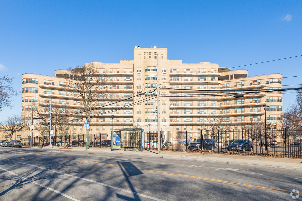
Experience Jamaica living at The T Building. Located at 82-41 Parsons Blvd in Jamaica, this community is convenient to everything. Let the leasing team show you everything this community has in store. Compare 0 to 3 bedroom apartments. It's time to come home to The T Building. Contact us or stop in to discuss your new apartment.
The T Building is an apartment community located in Queens County and the 11432 ZIP Code. This area is served by the New York City Geographic District #28 attendance zone.
Laundry Facilities
Concierge
Playground
Business Center
Air Conditioning
Tub/Shower
Heating
Oven
Homes for rent line the streets of the peaceful Hillcrest neighborhood in Fresh Meadows. Residents of this quiet section of Queens take pride in their high-quality school system and enjoy their easy commute to Manhattan. The variety of classic brownstones and New York apartment buildings make this a diverse renter’s paradise.
Cunningham Park, just east of Hillcrest, serves as an easy getaway for Hillcrest locals with its sports courts that range from football and basketball to bocce and cricket. Hiking trails and dog-friendly areas make this park an ideal place to relax. Travel down Union Turnpike, the heart of the Hillcrest commercial district, and stop at one of the many restaurants, cafes, delis, and coffee shops on the street.
Learn more about living in HillcrestCompare neighborhood and city base rent averages by bedroom.
| Hillcrest | Jamaica, NY | |
|---|---|---|
| Studio | $1,542 | $1,754 |
| 1 Bedroom | $1,715 | $2,221 |
| 2 Bedrooms | $1,938 | $2,756 |
| 3 Bedrooms | $2,231 | $3,478 |
| Colleges & Universities | Distance | ||
|---|---|---|---|
| Colleges & Universities | Distance | ||
| Drive: | 4 min | 1.3 mi | |
| Drive: | 4 min | 1.4 mi | |
| Drive: | 6 min | 2.7 mi | |
| Drive: | 9 min | 4.7 mi |


Transportation options available in Jamaica include Parsons Boulevard, located 0.8 mile from The T Building. The T Building is near LaGuardia, located 6.4 miles or 12 minutes away, and John F Kennedy International, located 7.2 miles or 11 minutes away.
| Transit / Subway | Distance | ||
|---|---|---|---|
| Transit / Subway | Distance | ||
|
|
Walk: | 15 min | 0.8 mi |
|
|
Drive: | 3 min | 1.2 mi |
|
|
Drive: | 3 min | 1.2 mi |
|
|
Drive: | 3 min | 1.3 mi |
|
|
Drive: | 3 min | 1.4 mi |
| Commuter Rail | Distance | ||
|---|---|---|---|
| Commuter Rail | Distance | ||
|
|
Drive: | 4 min | 1.6 mi |
|
|
Drive: | 5 min | 1.9 mi |
|
|
Drive: | 6 min | 2.4 mi |
|
|
Drive: | 6 min | 2.4 mi |
|
|
Drive: | 7 min | 3.0 mi |
| Airports | Distance | ||
|---|---|---|---|
| Airports | Distance | ||
|
LaGuardia
|
Drive: | 12 min | 6.4 mi |
|
John F Kennedy International
|
Drive: | 11 min | 7.2 mi |
Scores provided by
Traffic
-Airport
-Businesses
-Scores provided by
HowLoud What is a Sound Score Rating? A Sound Score Rating aggregates noise caused by vehicle traffic, airplane traffic and local sources. How It WorksTime and distance from The T Building.
| Shopping Centers | Distance | ||
|---|---|---|---|
| Shopping Centers | Distance | ||
| Drive: | 3 min | 1.2 mi | |
| Drive: | 3 min | 1.2 mi | |
| Drive: | 5 min | 1.3 mi |
| Parks and Recreation | Distance | ||
|---|---|---|---|
| Parks and Recreation | Distance | ||
|
Rufus King Park
|
Drive: | 4 min | 1.3 mi |
|
Detective Keith L. Williams Park
|
Drive: | 6 min | 2.2 mi |
|
Kissena Park
|
Drive: | 7 min | 2.4 mi |
|
Cunningham Park
|
Drive: | 5 min | 2.9 mi |
|
Forest Park - Brooklyn-Queens
|
Drive: | 7 min | 3.4 mi |
| Hospitals | Distance | ||
|---|---|---|---|
| Hospitals | Distance | ||
| Walk: | 8 min | 0.4 mi | |
| Drive: | 4 min | 1.7 mi | |
| Drive: | 7 min | 3.1 mi |
| Military Bases | Distance | ||
|---|---|---|---|
| Military Bases | Distance | ||
| Drive: | 13 min | 7.7 mi | |
| Drive: | 25 min | 14.5 mi | |
| Drive: | 33 min | 16.0 mi |
What Are Walk Score®, Transit Score®, and Bike Score® Ratings?
Walk Score® measures the walkability of any address. Transit Score® measures access to public transit. Bike Score® measures the bikeability of any address.
What is a Sound Score Rating?
A Sound Score Rating aggregates noise caused by vehicle traffic, airplane traffic and local sources.

82-41 Parsons Blvd
Jamaica, NY 11432


