
Sunrise Apartments
500 Sunrise Ave,
Roseville,
CA
95661
-
Monthly Rent
$1,650 - $1,950
-
Bedrooms
1 - 2 bd
-
Bathrooms
1 ba
-
Square Feet
576 - 720 sq ft
Newly renovated apartment homes - Visit Sunrise Apartments and see for yourself! Contact us today to schedule a personal tour to view your next home at Sunrise Apartments; located at 500 SUNRISE AVENUE, in Roseville, California. (entrance to parking lot located on Smith Lane.) Sunrise Apartments is nestled in the Cirby Side neighborhood, with 3 shopping centers within a mile, including great restaurants and along the bus line as well. Our community boasts a sparkling pool, new landscaping, laundry facility, on-site management, online rent payments, as well as many additional features for your comfort and convenience inside your apartment home. Contact us today to schedule your personal tour!
Highlights
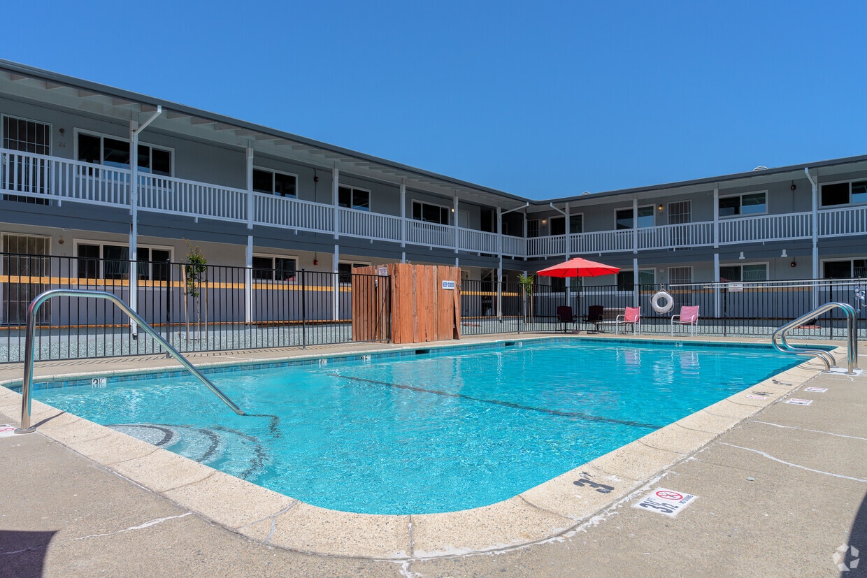
- Pool
- Property Manager on Site
Pricing & Floor Plans
-
Unit 23price $1,650square feet 576availibility Now
-
Unit 22price $1,650square feet 576availibility Now
-
Unit 13price $1,950square feet 720availibility Now
-
Unit 12price $1,950square feet 720availibility Now
-
Unit 23price $1,650square feet 576availibility Now
-
Unit 22price $1,650square feet 576availibility Now
-
Unit 13price $1,950square feet 720availibility Now
-
Unit 12price $1,950square feet 720availibility Now
Fees and Policies
The fees listed below are community-provided and may exclude utilities or add-ons. All payments are made directly to the property and are non-refundable unless otherwise specified. Use the Cost Calculator to determine costs based on your needs.
-
One-Time Basics
-
Due at Application
-
Application Fee Per ApplicantAll adults over 18 in same household must complete an application. Charged per applicant.$60
-
-
Due at Application
Pet policies are negotiable.
-
Dogs
-
Pet DepositCharged per pet.$0
25 lbs. Weight Limit, Pet interview, Spayed/NeuteredCommentsMust sign a pet agreementRead More Read Less -
-
Cats
-
Pet DepositCharged per unit.$0
25 lbs. Weight Limit, Pet interview, Spayed/NeuteredComments -
Property Fee Disclaimer: Based on community-supplied data and independent market research. Subject to change without notice. May exclude fees for mandatory or optional services and usage-based utilities.
Details
Utilities Included
-
Water
-
Trash Removal
-
Sewer
Lease Options
-
1+ mo
-
Short term lease
Property Information
-
Built in 1960
-
26 units/2 stories
Matterport 3D Tours
About Sunrise Apartments
Newly renovated apartment homes - Visit Sunrise Apartments and see for yourself! Contact us today to schedule a personal tour to view your next home at Sunrise Apartments; located at 500 SUNRISE AVENUE, in Roseville, California. (entrance to parking lot located on Smith Lane.) Sunrise Apartments is nestled in the Cirby Side neighborhood, with 3 shopping centers within a mile, including great restaurants and along the bus line as well. Our community boasts a sparkling pool, new landscaping, laundry facility, on-site management, online rent payments, as well as many additional features for your comfort and convenience inside your apartment home. Contact us today to schedule your personal tour!
Sunrise Apartments is an apartment community located in Placer County and the 95661 ZIP Code. This area is served by the Roseville City Elementary School District attendance zone.
Unique Features
- On-site Management
- Built-in Microwave
- Dishwasher
- Pool
- Electric Range/oven
- Dual Pane Windows
- On-site Mgmt
- Pool, Laundry Facilities
- Laundry Facilities
Contact
Community Amenities
Pool
Laundry Facilities
Property Manager on Site
Public Transportation
- Laundry Facilities
- Property Manager on Site
- Renters Insurance Program
- Public Transportation
- Pool
Apartment Features
Air Conditioning
Dishwasher
Microwave
Refrigerator
Tub/Shower
Disposal
Ice Maker
Ceiling Fans
Indoor Features
- Air Conditioning
- Heating
- Ceiling Fans
- Cable Ready
- Storage Space
- Tub/Shower
- Handrails
Kitchen Features & Appliances
- Dishwasher
- Disposal
- Ice Maker
- Kitchen
- Microwave
- Oven
- Range
- Refrigerator
Model Details
- Carpet
- Vinyl Flooring
- Linen Closet
- Double Pane Windows
- Window Coverings
Located in the Sacramento Valley, Roseville combines residential comfort with city conveniences. The city offers diverse housing options throughout its neighborhoods, from newer developments near Westfield Galleria to historic properties in Old Town. Current rental trends show steady market conditions, with one-bedroom apartments averaging $1,921 per month, while larger three-bedroom units typically rent for $2,780. The city's rental market has remained relatively stable, with modest year-over-year increases ranging from 0.9% to 2.3% across different unit sizes.
What began as a railroad town has evolved into a shopping and entertainment hub that maintains its small-town atmosphere. The Fountains at Roseville and Westfield Galleria provide extensive retail options, while Maidu Regional Park and Royer Park offer recreational spaces. Major employers like Kaiser Permanente and Hewlett Packard Enterprise contribute to local employment opportunities.
Learn more about living in RosevilleCompare neighborhood and city base rent averages by bedroom.
| Cirby Side | Roseville, CA | |
|---|---|---|
| Studio | - | $1,509 |
| 1 Bedroom | $1,651 | $1,937 |
| 2 Bedrooms | $1,995 | $2,335 |
| 3 Bedrooms | - | $2,790 |
- Laundry Facilities
- Property Manager on Site
- Renters Insurance Program
- Public Transportation
- Pool
- On-site Management
- Built-in Microwave
- Dishwasher
- Pool
- Electric Range/oven
- Dual Pane Windows
- On-site Mgmt
- Pool, Laundry Facilities
- Laundry Facilities
- Air Conditioning
- Heating
- Ceiling Fans
- Cable Ready
- Storage Space
- Tub/Shower
- Handrails
- Dishwasher
- Disposal
- Ice Maker
- Kitchen
- Microwave
- Oven
- Range
- Refrigerator
- Carpet
- Vinyl Flooring
- Linen Closet
- Double Pane Windows
- Window Coverings
| Monday | 9am - 1pm |
|---|---|
| Tuesday | 9am - 5pm |
| Wednesday | 9am - 5pm |
| Thursday | 9am - 5pm |
| Friday | 9am - 5pm |
| Saturday | 10am - 2pm |
| Sunday | Closed |
| Colleges & Universities | Distance | ||
|---|---|---|---|
| Colleges & Universities | Distance | ||
| Drive: | 9 min | 5.3 mi | |
| Drive: | 17 min | 8.8 mi | |
| Drive: | 27 min | 13.4 mi | |
| Drive: | 27 min | 17.1 mi |


View GreatSchools Rating Methodology
Data provided by GreatSchools.org © 2026. All rights reserved.
Transportation options available in Roseville include Watt/I-80, located 9.5 miles from Sunrise Apartments. Sunrise Apartments is near Sacramento International, located 24.6 miles or 34 minutes away.
| Transit / Subway | Distance | ||
|---|---|---|---|
| Transit / Subway | Distance | ||
|
|
Drive: | 14 min | 9.5 mi |
|
|
Drive: | 17 min | 10.5 mi |
|
|
Drive: | 17 min | 10.5 mi |
|
|
Drive: | 19 min | 11.3 mi |
|
|
Drive: | 20 min | 12.3 mi |
| Commuter Rail | Distance | ||
|---|---|---|---|
| Commuter Rail | Distance | ||
|
|
Drive: | 7 min | 2.5 mi |
|
|
Drive: | 8 min | 4.5 mi |
| Drive: | 21 min | 16.7 mi | |
|
|
Drive: | 21 min | 16.7 mi |
| Drive: | 24 min | 18.0 mi |
| Airports | Distance | ||
|---|---|---|---|
| Airports | Distance | ||
|
Sacramento International
|
Drive: | 34 min | 24.6 mi |
Time and distance from Sunrise Apartments.
| Shopping Centers | Distance | ||
|---|---|---|---|
| Shopping Centers | Distance | ||
| Walk: | 14 min | 0.7 mi | |
| Walk: | 14 min | 0.7 mi | |
| Walk: | 15 min | 0.8 mi |
| Parks and Recreation | Distance | ||
|---|---|---|---|
| Parks and Recreation | Distance | ||
|
Sierra College Natural History Museum
|
Drive: | 8 min | 5.3 mi |
|
Jensen Botanical Gardens
|
Drive: | 14 min | 8.7 mi |
|
Folsom Powerhouse State Historic Park
|
Drive: | 18 min | 10.1 mi |
|
The Discovery Museum Science & Space Center
|
Drive: | 16 min | 10.3 mi |
|
Folsom City Zoo Sanctuary
|
Drive: | 19 min | 10.7 mi |
| Hospitals | Distance | ||
|---|---|---|---|
| Hospitals | Distance | ||
| Drive: | 4 min | 2.2 mi | |
| Drive: | 6 min | 2.6 mi | |
| Drive: | 11 min | 6.3 mi |
| Military Bases | Distance | ||
|---|---|---|---|
| Military Bases | Distance | ||
| Drive: | 25 min | 11.6 mi |
Sunrise Apartments Photos
-
Sunrise Apartments
-
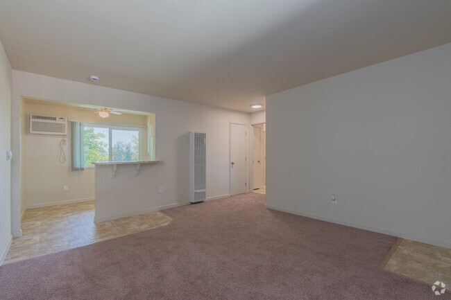
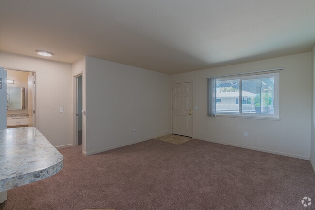
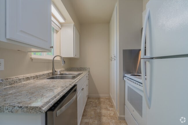
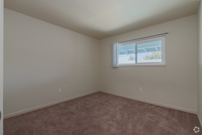
1BR, 1BA - 600SF
-
1BR, 1BA - 600SF - Living Room
-
1BR, 1BA - 600SF - Living Room
-
1BR, 1BA - 600SF - Kitchen
-
1BR, 1BA - 600SF - Bedroom
-
1BR, 1BA - 600SF - Bedroom
-
1BR, 1BA - 600SF - Bedroom
-
2BR, 1BA - 700SF - Living Room
While Sunrise Apartments does not provide in‑unit laundry, on‑site laundry facilities are available for shared resident use.
Select utilities are included in rent at Sunrise Apartments, including water, trash removal, and sewer. Residents are responsible for any other utilities not listed.
Parking is available at Sunrise Apartments and is free of charge for residents.
Sunrise Apartments has one to two-bedrooms with rent ranges from $1,650/mo. to $1,950/mo.
Yes, Sunrise Apartments welcomes pets. Breed restrictions, weight limits, and additional fees may apply. View this property's pet policy.
A good rule of thumb is to spend no more than 30% of your gross income on rent. Based on the lowest available rent of $1,650 for a one-bedroom, you would need to earn about $66,000 per year to qualify. Want to double-check your budget? Calculate how much rent you can afford with our Rent Affordability Calculator.
Sunrise Apartments is not currently offering any rent specials. Check back soon, as promotions change frequently.
Yes! Sunrise Apartments offers 4 Matterport 3D Tours. Explore different floor plans and see unit level details, all without leaving home.
What Are Walk Score®, Transit Score®, and Bike Score® Ratings?
Walk Score® measures the walkability of any address. Transit Score® measures access to public transit. Bike Score® measures the bikeability of any address.
What is a Sound Score Rating?
A Sound Score Rating aggregates noise caused by vehicle traffic, airplane traffic and local sources.
500 Sunrise Ave
Roseville, CA 95661