-
Stonegate

-
Stonegate
-
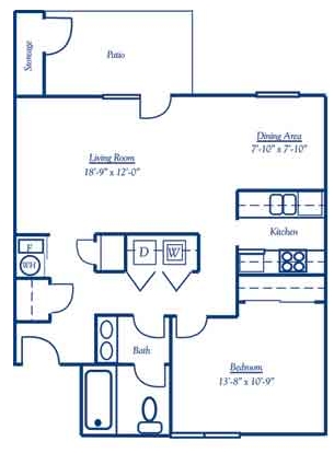
1BR/1BA
-
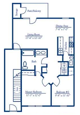
2BR/1BA
Stonegate
301 N Graham St,
Cambridge City,
IN
47327
2 Weeks Ago
Favorites
Stonegate
Favorites
Highlights
- Balcony
- Property Manager on Site
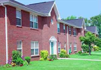
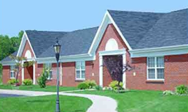
About Stonegate
Explore Cambridge City living at Stonegate. Schedule a time to check out the apartment floorplan options. These apartments offer a variety of features and amenities. These include: rentable storage units, vaulted ceilings, and convenient on-site parking options. From availability to location, the professional leasing team is ready and waiting to help you find the perfect new apartment. Contact us or drop by the leasing office to schedule a tour and make your move to Stonegate.
Stonegate is an apartment community located in Wayne County and the 47327 ZIP Code. This area is served by the Western Wayne Schools attendance zone.
Community Amenities
- Laundry Facilities
- Property Manager on Site
Apartment Features
Washer/Dryer
Air Conditioning
Dishwasher
High Speed Internet Access
- High Speed Internet Access
- Washer/Dryer
- Air Conditioning
- Heating
- Smoke Free
- Cable Ready
- Storage Space
- Dishwasher
- Disposal
- Kitchen
- Range
- Refrigerator
- Vaulted Ceiling
- Balcony
301 N Graham St,
Cambridge City,
IN
47327
Education
| Colleges & Universities | Distance | ||
|---|---|---|---|
| Colleges & Universities | Distance | ||
| Drive: | 24 min | 17.5 mi | |
| Drive: | 58 min | 36.2 mi | |
| Drive: | 65 min | 39.2 mi | |
| Drive: | 64 min | 46.4 mi |
Stonegate is within 24 minutes or 17.5 miles from Indiana University East. It is also near Ball State University and Miami University.
Schools


Public Elementary School
Grades PK-5
626 Students
Nearby
Public Elementary School
Grades PK-5
347 Students
Attendance Zone
Public Middle School
Grades 6-8
162 Students
Attendance Zone
Public High School
Grades 9-12
242 Students
Nearby
Private Elementary & Middle School
Grades K-8
30 Students
Nearby
Private Elementary & Middle School
Grades K-8
28 Students
Nearby
Private Elementary School
Grades PK-5
141 Students
Nearby
Private Elementary, Middle & High School
Grades PK-12
48 Students
Nearby
School data provided by
 The GreatSchools Rating helps parents compare schools within a state based on a variety of school quality indicators and provides a helpful picture of how effectively each school serves all of its students. Ratings are on a scale of 1 (below average) to 10 (above average) and can include test scores, college readiness, academic progress, advanced courses, equity, discipline and attendance data. We also advise parents to visit schools, consider other information on school performance and programs, and consider family needs as part of the school selection process.
View GreatSchools Rating Methodology
Data provided by GreatSchools.org © 2026. All rights reserved.
View GreatSchools Rating Methodology
Data provided by GreatSchools.org © 2026. All rights reserved.
Walkability Near Stonegate
Getting Around
 What do Walkability, Transit, Drivability, and Bikeability mean?
Walkability measures the walking distance to day-to-day needs.
Transit measures access to public transportation.
Drivability measures congestion, parking availability, and access to major roads.
Bikeability measures the suitability for cycling.
How It Works
What do Walkability, Transit, Drivability, and Bikeability mean?
Walkability measures the walking distance to day-to-day needs.
Transit measures access to public transportation.
Drivability measures congestion, parking availability, and access to major roads.
Bikeability measures the suitability for cycling.
How It Works
Somewhat Walkable
Walkability
30
/ 100
Very Drivable
Drivability
80
/ 100
Somewhat Bikeable
Bikeability
30
/ 100
Scores provided by
-
Soundscore™
-
/ 100
Traffic
-Airport
-Businesses
-Scores provided by
HowLoud What is a Sound Score Rating? A Sound Score Rating aggregates noise caused by vehicle traffic, airplane traffic and local sources. How It WorksExplore Similar Rentals Nearby


What Are Walk Score®, Transit Score®, and Bike Score® Ratings?
Walk Score® measures the walkability of any address. Transit Score® measures access to public transit. Bike Score® measures the bikeability of any address.
What is a Sound Score Rating?
A Sound Score Rating aggregates noise caused by vehicle traffic, airplane traffic and local sources.
301 N Graham St
Cambridge City, IN 47327