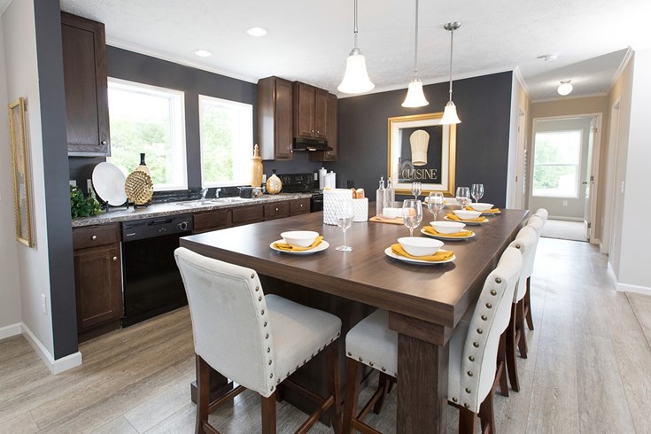
Riverbrook
59477 Hardy Ln,
New Haven,
MI
48048
2 Weeks Ago
Favorites
Riverbrook
Favorites
Highlights
- Basketball Court
- Pool
- Picnic Area
- Property Manager on Site
About Riverbrook
NEW HOMES COMING IN FALL OF 2019! Please call for details
Riverbrook is an apartment community located in Macomb County and the 48048 ZIP Code. This area is served by the Merritt Academy attendance zone.
Community Amenities
Pool
Fitness Center
Playground
Clubhouse
- Property Manager on Site
- Clubhouse
- Storage Space
- Walk-Up
- Fitness Center
- Pool
- Playground
- Basketball Court
- Picnic Area
59477 Hardy Ln,
New Haven,
MI
48048
New Haven is a village in Lenox Township, located in Macomb County only six miles out from Anchor Bay. New Haven is about a 50-minute drive from Detroit, with residents enjoying direct access to I-94 by way of New Haven Road.
For some tee time and relaxation, Oak Ridge Golf Course is right down the road. There’s a handful of parks that are great for walking the dog, taking the kids to play, or to just get out and enjoy the day. You’ll love the wide selection of restaurants offered.
Learn more about living in New Haven
Education
| Colleges & Universities | Distance | ||
|---|---|---|---|
| Colleges & Universities | Distance | ||
| Drive: | 25 min | 14.9 mi | |
| Drive: | 23 min | 17.3 mi | |
| Drive: | 31 min | 22.8 mi | |
| Drive: | 42 min | 29.3 mi |
Riverbrook is within 25 minutes or 14.9 miles from Univ. of Detroit Mercy, Ctr. It is also near Baker Coll. Clinton Township and Macomb Community College.
Schools

Charter Elementary & Middle School
Grades PK-8
200 Students
Nearby
Public Elementary, Middle & High School
Grades PK-12
572 Students
Nearby
Public High School
Grades 9-12
329 Students
Attendance Zone
Private Elementary, Middle & High School
Grades K-12
47 Students
Nearby
Private Elementary & Middle School
Grades K-8
78 Students
Nearby
Private High School
Grades 9-12
102 Students
Nearby
School data provided by
 The GreatSchools Rating helps parents compare schools within a state based on a variety of school quality indicators and provides a helpful picture of how effectively each school serves all of its students. Ratings are on a scale of 1 (below average) to 10 (above average) and can include test scores, college readiness, academic progress, advanced courses, equity, discipline and attendance data. We also advise parents to visit schools, consider other information on school performance and programs, and consider family needs as part of the school selection process.
View GreatSchools Rating Methodology
Data provided by GreatSchools.org © 2026. All rights reserved.
View GreatSchools Rating Methodology
Data provided by GreatSchools.org © 2026. All rights reserved.
Walkability Near Riverbrook
Getting Around
 What do Walkability, Transit, Drivability, and Bikeability mean?
Walkability measures the walking distance to day-to-day needs.
Transit measures access to public transportation.
Drivability measures congestion, parking availability, and access to major roads.
Bikeability measures the suitability for cycling.
How It Works
What do Walkability, Transit, Drivability, and Bikeability mean?
Walkability measures the walking distance to day-to-day needs.
Transit measures access to public transportation.
Drivability measures congestion, parking availability, and access to major roads.
Bikeability measures the suitability for cycling.
How It Works
Somewhat Walkable
Walkability
30
/ 100
Exceptionally Drivable
Drivability
90
/ 100
Somewhat Bikeable
Bikeability
30
/ 100
Scores provided by
Active
Soundscore™
74
/ 100
Traffic
ActiveAirport
CalmBusinesses
CalmScores provided by
HowLoud What is a Sound Score Rating? A Sound Score Rating aggregates noise caused by vehicle traffic, airplane traffic and local sources. How It WorksExplore Similar Rentals Nearby


What Are Walk Score®, Transit Score®, and Bike Score® Ratings?
Walk Score® measures the walkability of any address. Transit Score® measures access to public transit. Bike Score® measures the bikeability of any address.
What is a Sound Score Rating?
A Sound Score Rating aggregates noise caused by vehicle traffic, airplane traffic and local sources.

59477 Hardy Ln
New Haven, MI 48048