
The Lofts at Gloucester Township
752 Davistown Rd,
Blackwood, NJ 08012
$2,269 - $2,836
1-2 Beds


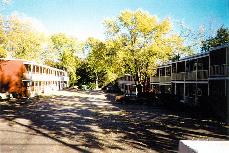


Find your new apartment at Oasis in Blackwood. The location in Blackwood's 08012 area is an ideal place to move. Be sure to check out the current floorplan options. The professional leasing staff is waiting to show you all that this community has to offer. It's time to love where you live. Stop by for a visit today.
Oasis is an apartment community located in Camden County and the 08012 ZIP Code. This area is served by the Gloucester Township Public School District attendance zone.
Air Conditioning
High Speed Internet Access
Tub/Shower
Smoke Free
| Colleges & Universities | Distance | ||
|---|---|---|---|
| Colleges & Universities | Distance | ||
| Drive: | 7 min | 3.2 mi | |
| Drive: | 11 min | 5.0 mi | |
| Drive: | 16 min | 9.2 mi | |
| Drive: | 17 min | 11.4 mi |


Transportation options available in Blackwood include Lindenwold (Patco), located 5.4 miles from Oasis. Oasis is near Philadelphia International, located 17.7 miles or 30 minutes away.
| Transit / Subway | Distance | ||
|---|---|---|---|
| Transit / Subway | Distance | ||
|
|
Drive: | 10 min | 5.4 mi |
|
|
Drive: | 11 min | 6.4 mi |
|
|
Drive: | 12 min | 7.2 mi |
|
|
Drive: | 14 min | 8.0 mi |
|
|
Drive: | 14 min | 8.4 mi |
| Commuter Rail | Distance | ||
|---|---|---|---|
| Commuter Rail | Distance | ||
|
|
Drive: | 10 min | 5.4 mi |
|
|
Drive: | 17 min | 10.3 mi |
|
|
Drive: | 16 min | 10.3 mi |
|
|
Drive: | 32 min | 17.3 mi |
|
|
Drive: | 30 min | 17.8 mi |
| Airports | Distance | ||
|---|---|---|---|
| Airports | Distance | ||
|
Philadelphia International
|
Drive: | 30 min | 17.7 mi |
Scores provided by
Traffic
-Airport
-Businesses
-Scores provided by
HowLoud What is a Sound Score Rating? A Sound Score Rating aggregates noise caused by vehicle traffic, airplane traffic and local sources. How It WorksTime and distance from Oasis.
| Shopping Centers | Distance | ||
|---|---|---|---|
| Shopping Centers | Distance | ||
| Drive: | 3 min | 1.5 mi | |
| Drive: | 3 min | 1.6 mi | |
| Drive: | 4 min | 1.9 mi |
| Parks and Recreation | Distance | ||
|---|---|---|---|
| Parks and Recreation | Distance | ||
|
Downs Farms Trails
|
Drive: | 12 min | 7.1 mi |
|
Croft Farm Nature Trail
|
Drive: | 15 min | 8.6 mi |
|
Kresson Nature Trails
|
Drive: | 17 min | 9.2 mi |
|
Erlton North Trails
|
Drive: | 16 min | 9.7 mi |
|
Barclay Farmstead Nature Trail
|
Drive: | 18 min | 10.2 mi |
| Hospitals | Distance | ||
|---|---|---|---|
| Hospitals | Distance | ||
| Drive: | 4 min | 2.4 mi | |
| Drive: | 8 min | 4.6 mi | |
| Drive: | 20 min | 12.0 mi |
| Military Bases | Distance | ||
|---|---|---|---|
| Military Bases | Distance | ||
| Drive: | 20 min | 12.8 mi |
What Are Walk Score®, Transit Score®, and Bike Score® Ratings?
Walk Score® measures the walkability of any address. Transit Score® measures access to public transit. Bike Score® measures the bikeability of any address.
What is a Sound Score Rating?
A Sound Score Rating aggregates noise caused by vehicle traffic, airplane traffic and local sources.

415 Hamilton Ave
Blackwood, NJ 08012


