
The Edge on the Boulevard
34500 Fremont Blvd,
Fremont, CA 94555
$2,025 - $2,350
Studio - 2 Beds
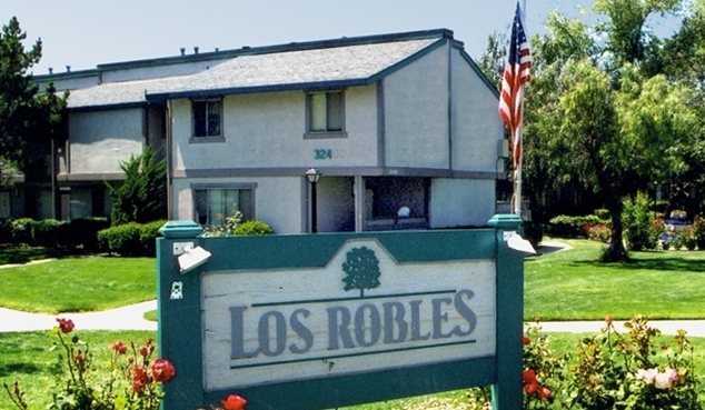
At Los Robles in Union City, CA, you've discovered your new home. These apartments are located on Almaden Blvd in the 94587 area of Union City. From amenities to floorplan options, the leasing team will be ready to help you find your perfect new apartment. Schedule a time to see the current floorplan options. Stop by Los Robles today.
Los Robles is an apartment community located in Alameda County and the 94587 ZIP Code. This area is served by the New Haven Unified School District attendance zone.
Laundry Facilities
Playground
Clubhouse
Business Center
Washer/Dryer
Dishwasher
Washer/Dryer Hookup
High Speed Internet Access
Compare neighborhood and city base rent averages by bedroom.
| Union City/East Outer Hayward | Union City, CA | |
|---|---|---|
| Studio | $2,185 | $2,308 |
| 1 Bedroom | $2,319 | $2,485 |
| 2 Bedrooms | $2,214 | $2,876 |
| 3 Bedrooms | - | $3,434 |
| Colleges & Universities | Distance | ||
|---|---|---|---|
| Colleges & Universities | Distance | ||
| Drive: | 10 min | 6.1 mi | |
| Drive: | 11 min | 6.9 mi | |
| Drive: | 11 min | 7.8 mi | |
| Drive: | 20 min | 13.2 mi |


Transportation options available in Union City include Union City, located 2.9 miles from Los Robles. Los Robles is near Metro Oakland International, located 14.8 miles or 20 minutes away, and Norman Y Mineta San Jose International, located 22.6 miles or 29 minutes away.
| Transit / Subway | Distance | ||
|---|---|---|---|
| Transit / Subway | Distance | ||
|
|
Drive: | 7 min | 2.9 mi |
|
|
Drive: | 9 min | 4.8 mi |
|
|
Drive: | 10 min | 6.3 mi |
|
|
Drive: | 14 min | 6.7 mi |
|
|
Drive: | 16 min | 9.9 mi |
| Commuter Rail | Distance | ||
|---|---|---|---|
| Commuter Rail | Distance | ||
| Drive: | 10 min | 5.1 mi | |
| Drive: | 10 min | 5.3 mi | |
| Drive: | 10 min | 6.7 mi | |
|
|
Drive: | 10 min | 6.7 mi |
| Drive: | 30 min | 20.9 mi |
| Airports | Distance | ||
|---|---|---|---|
| Airports | Distance | ||
|
Metro Oakland International
|
Drive: | 20 min | 14.8 mi |
|
Norman Y Mineta San Jose International
|
Drive: | 29 min | 22.6 mi |
Scores provided by
Traffic
-Airport
-Businesses
-Scores provided by
HowLoud What is a Sound Score Rating? A Sound Score Rating aggregates noise caused by vehicle traffic, airplane traffic and local sources. How It WorksTime and distance from Los Robles.
| Shopping Centers | Distance | ||
|---|---|---|---|
| Shopping Centers | Distance | ||
| Walk: | 18 min | 1.0 mi | |
| Drive: | 5 min | 1.9 mi | |
| Drive: | 5 min | 1.9 mi |
| Parks and Recreation | Distance | ||
|---|---|---|---|
| Parks and Recreation | Distance | ||
|
Coyote Hills Regional Park
|
Drive: | 8 min | 3.3 mi |
|
Alameda Creek Regional Trail
|
Drive: | 8 min | 3.5 mi |
|
Garin/Dry Creek Pioneer Parks
|
Drive: | 8 min | 3.7 mi |
|
Ardenwood Historic Farm
|
Drive: | 7 min | 3.8 mi |
|
Quarry Lakes Regional Recreation Area
|
Drive: | 8 min | 3.9 mi |
| Hospitals | Distance | ||
|---|---|---|---|
| Hospitals | Distance | ||
| Drive: | 7 min | 3.9 mi | |
| Drive: | 13 min | 6.5 mi | |
| Drive: | 13 min | 6.6 mi |
| Military Bases | Distance | ||
|---|---|---|---|
| Military Bases | Distance | ||
| Drive: | 31 min | 21.2 mi | |
| Drive: | 32 min | 22.3 mi | |
| Drive: | 32 min | 22.5 mi |
Pets Allowed Fitness Center In Unit Washer & Dryer Stainless Steel Appliances Business Center Package Service Elevator
What Are Walk Score®, Transit Score®, and Bike Score® Ratings?
Walk Score® measures the walkability of any address. Transit Score® measures access to public transit. Bike Score® measures the bikeability of any address.
What is a Sound Score Rating?
A Sound Score Rating aggregates noise caused by vehicle traffic, airplane traffic and local sources.

32300 Almaden Blvd
Union City, CA 94587


