

$1,800
/ Month
1710 E 31st St
Baltimore, MD 21218
2 Weeks Ago
|
Edit
Favorites
-
Bedrooms
3
-
Bathrooms
1.5
-
Square Feet
1,800 sq ft
1710 E 31st St

Favorites
About This Home
$1,800 deposit
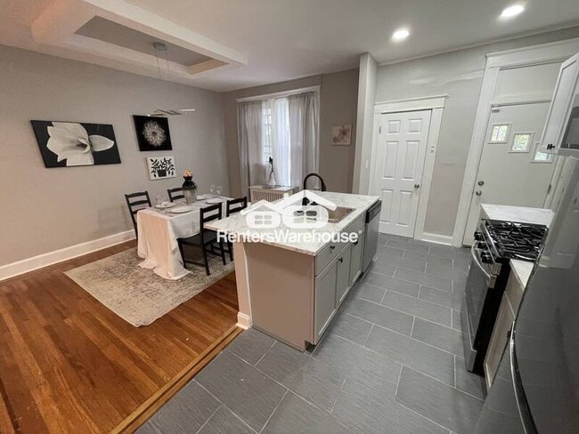
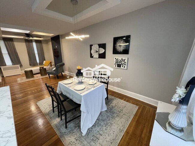
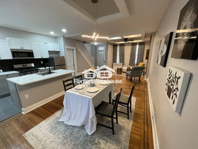
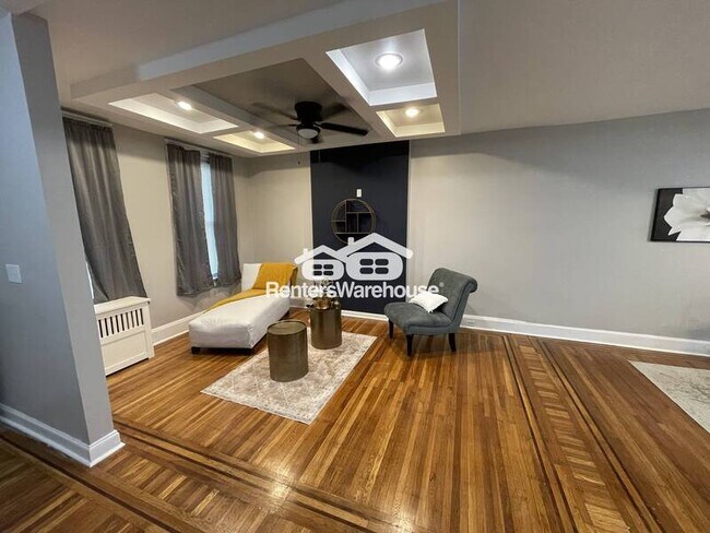
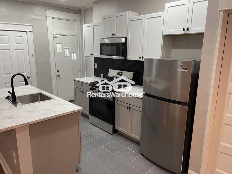
This is a stunning 3 Bed 1.5 Bath townhouse located in Baltimore! First level you will find a spacious open floor plan with a gorgeous kitchen complete with granite countertops and stainless steel appliances! You will also find a half bath on the first level! Second floor you will find 3 spacious bedrooms and a gorgeous full bath! Home comes with washer and dryer!! BOOK A TOUR TODAY
1710 E 31st St is a house located in Baltimore City County and the 21218 ZIP Code. This area is served by the Baltimore City Public Schools attendance zone.
* Price shown is base rent. Excludes user-selected optional fees and variable or usage-based fees and required charges due at or prior to move-in or at move-out. Price, availability, fees, and any applicable rent special are subject to change without notice.
* Square footage definitions vary. Displayed square footage is approximate.
House Features
- Dishwasher
- Refrigerator
Fees and Policies
The fees below are based on community-supplied data and may exclude additional fees and utilities.
- Dogs Allowed
-
Fees not specified
- Cats Allowed
-
Fees not specified
Contact
Location
Get Directions
Amenities
- Dishwasher
- Refrigerator
Midway Coldstream is located between Lock Raven Road and Hartford Road, with Clifton Park on its southeast side. Lake Montebello is adjacent to the neighborhood, and a lakefront park with a playground is located along East 32nd Street. Midway Coldstream is home to Baltimore City College, a public magnet high school. This neighborhood makes up a large portion of the Coldstream-Homestead-Montebello Historic District, which is listed on the National Register of Historic Places.
Conveniently located, Midway Coldstream is roughly a mile southeast of Johns Hopkins University and about two miles northeast of Downtown Baltimore. Baltimore City College, nicknamed the "Castle on the Hill" is a college preparatory school with a liberal arts focus. The school dates back to 1839, of the oldest active high schools in the country.
Learn more about living in Midway-Coldstream
Education
| Colleges & Universities | Distance | ||
|---|---|---|---|
| Colleges & Universities | Distance | ||
| Drive: | 5 min | 1.7 mi | |
| Drive: | 8 min | 2.6 mi | |
| Drive: | 7 min | 2.6 mi | |
| Drive: | 11 min | 2.8 mi |
1710 E 31st St is within 5 minutes or 1.7 miles from Morgan State University. It is also near Johns Hopkins University and Loyola University Maryland.
Schools


Public Elementary & Middle School
Grades PK-8
468 Students
Attendance Zone
Charter Middle School
Grades 8
112 Students
Attendance Zone
Public Middle School
Grades 6-8
339 Students
Attendance Zone
Public High School
Grades 9-12
1,497 Students
Attendance Zone
Private Elementary, Middle & High School
Grades 2-12
130 Students
Nearby
Private Elementary, Middle & High School
Grades PK-11
Nearby
Private Elementary & Middle School
Grades PK-8
Nearby
Private Elementary & Middle School
Grades 3-7
Nearby
School data provided by
 The GreatSchools Rating helps parents compare schools within a state based on a variety of school quality indicators and provides a helpful picture of how effectively each school serves all of its students. Ratings are on a scale of 1 (below average) to 10 (above average) and can include test scores, college readiness, academic progress, advanced courses, equity, discipline and attendance data. We also advise parents to visit schools, consider other information on school performance and programs, and consider family needs as part of the school selection process.
View GreatSchools Rating Methodology
Data provided by GreatSchools.org © 2025. All rights reserved.
View GreatSchools Rating Methodology
Data provided by GreatSchools.org © 2025. All rights reserved.
Transportation options available in Baltimore include Johns Hopkins Hospital, located 2.5 miles from 1710 E 31st St. 1710 E 31st St is near Baltimore/Washington International Thurgood Marshall, located 13.7 miles or 28 minutes away.
| Transit / Subway | Distance | ||
|---|---|---|---|
| Transit / Subway | Distance | ||
| Drive: | 7 min | 2.5 mi | |
|
|
Drive: | 7 min | 2.6 mi |
|
|
Drive: | 7 min | 2.7 mi |
|
|
Drive: | 8 min | 2.8 mi |
| Drive: | 8 min | 2.9 mi |
| Commuter Rail | Distance | ||
|---|---|---|---|
| Commuter Rail | Distance | ||
|
|
Drive: | 7 min | 2.4 mi |
|
|
Drive: | 12 min | 4.0 mi |
|
|
Drive: | 14 min | 5.3 mi |
|
|
Drive: | 24 min | 9.2 mi |
| Drive: | 25 min | 9.9 mi |
| Airports | Distance | ||
|---|---|---|---|
| Airports | Distance | ||
|
Baltimore/Washington International Thurgood Marshall
|
Drive: | 28 min | 13.7 mi |
Time and distance from 1710 E 31st St.
| Shopping Centers | Distance | ||
|---|---|---|---|
| Shopping Centers | Distance | ||
| Drive: | 4 min | 1.3 mi | |
| Drive: | 4 min | 1.4 mi | |
| Drive: | 4 min | 1.4 mi |
1710 E 31st St has 3 shopping centers within 1.4 miles, which is about a 4-minute drive. The miles and minutes will be for the farthest away property.
| Parks and Recreation | Distance | ||
|---|---|---|---|
| Parks and Recreation | Distance | ||
|
Clifton Park
|
Walk: | 20 min | 1.1 mi |
|
Herring Run Park
|
Drive: | 5 min | 1.6 mi |
|
Maryland Space Grant Consortium Observatory
|
Drive: | 8 min | 2.4 mi |
|
Patterson Park
|
Drive: | 10 min | 3.2 mi |
|
Port Discovery Children's Museum
|
Drive: | 10 min | 3.4 mi |
1710 E 31st St has 5 parks within 3.4 miles, including Clifton Park, Herring Run Park, and Maryland Space Grant Consortium Observatory.
| Hospitals | Distance | ||
|---|---|---|---|
| Hospitals | Distance | ||
| Drive: | 4 min | 1.6 mi | |
| Drive: | 6 min | 2.3 mi | |
| Drive: | 7 min | 2.3 mi |
1710 E 31st St has 3 hospitals within 2.3 miles, the nearest is MedStar Union Memorial Hospital which is 1.6 miles away and a 4 minute drive.
| Military Bases | Distance | ||
|---|---|---|---|
| Military Bases | Distance | ||
| Drive: | 40 min | 21.9 mi |
1710 E 31st St is 21.9 miles and a 40 minute drive from Fort George Meade.
You May Also Like
Similar Rentals Nearby


What Are Walk Score®, Transit Score®, and Bike Score® Ratings?
Walk Score® measures the walkability of any address. Transit Score® measures access to public transit. Bike Score® measures the bikeability of any address.
What is a Sound Score Rating?
A Sound Score Rating aggregates noise caused by vehicle traffic, airplane traffic and local sources
1710 E 31st St
Baltimore, MD 21218