

$1,395
/ Month
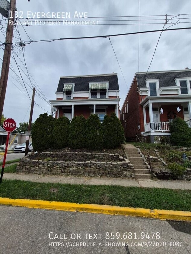
132 Evergreen Ave
Southgate, KY 41071
Today
Favorites
859-681-9478
-
Bedrooms
2
-
Bathrooms
1.5
-
Square Feet
--
-
Available
Available Now
132 Evergreen Ave

Favorites
About This Home
Available Now
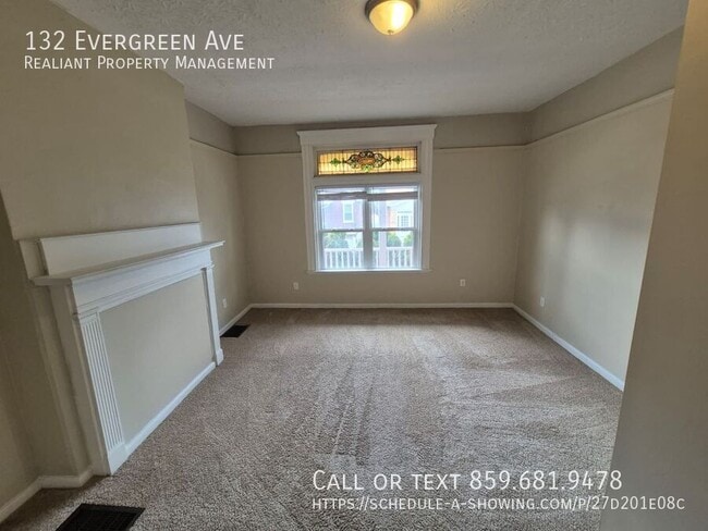
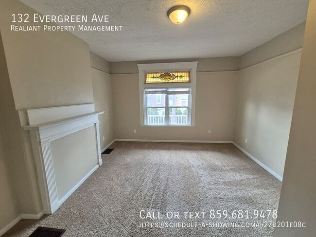
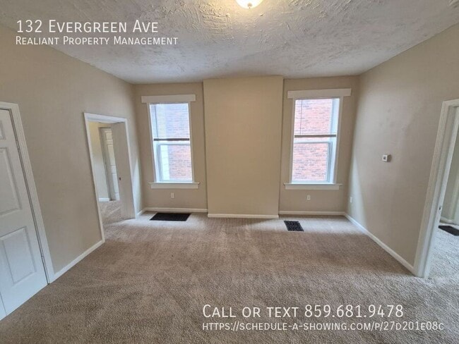
132 Evergreen Ave, Southgate – Beautiful 2-bedroom, 1.5-bath home in a highly sought-after neighborhood. Located in the top-ranked Highlands High School district and served by Southgate Public Schools for K–8th grade, this home is perfect for families seeking excellent schools. Enjoy the convenience of nearby shopping, dining, and local parks, all just minutes away. The neighborhood offers a friendly, walkable community with easy access to commuting routes, making it simple to get around the Greater Cincinnati area. This home combines comfort, location, and a vibrant lifestyle for those looking to settle in Southgate. All interested applicants over the age of 18 must complete a rental application and authorize a $65 credit and background check. A minimum credit score of 625 is required. Small pets permitted with a $300 non-refundable pet fee and $50/month pet rent.2 pets max. Schedule your showing today at Rentals--Northern, Ky. Beware of Scams! We will never ask you to send money via Venmo, CashApp, PayPal, Zelle, or any other peer-to-peer payment app. All payments are handled securely through our verified platforms. We DO NOT ACCEPT CASH. None
132 Evergreen Ave is an apartment community located in Campbell County and the 41071 ZIP Code.
* Price shown is base rent. Excludes user-selected optional fees and variable or usage-based fees and required charges due at or prior to move-in or at move-out. Price, availability, fees, and any applicable rent special are subject to change without notice.
* Square footage definitions vary. Displayed square footage is approximate.
Contact
- Listed by NKY Leasing
- Phone Number
- Contact
Location
Get Directions
A densely wooded suburb of Campbell County, Southgate is made up of a golf course, residential neighborhoods, and open land. Southgate’s residential streets are lined with paved sidewalks, well-maintained lawns, and unique craftsman style homes. A portion of the Highland County Club sits within Southgate, while the remainder of the course lies within Fort Thomas, Southgate’s riverfront neighbor.
Southgate is just a few miles west of the Ohio River and the Kentucky-Ohio state line. With Interstate 471 traveling directly through town, locals can easily get into Cincinnati, Ohio, which is just five miles northwest of town. Though Southgate is located in Kentucky, it’s closer to Ohio’s major metro areas! Residents can also travel south along Interstates 471 and 275, or back roads, to reach Northern Kentucky University directly south of Southgate.
Learn more about living in Southgate
Education
| Colleges & Universities | Distance | ||
|---|---|---|---|
| Colleges & Universities | Distance | ||
| Drive: | 8 min | 3.9 mi | |
| Drive: | 13 min | 7.1 mi | |
| Drive: | 13 min | 7.2 mi | |
| Drive: | 16 min | 8.7 mi |
132 Evergreen Ave is within 8 minutes or 3.9 miles from Northern Kentucky University. It is also near University of Cincinnati and Univ. of Cincinnati, Medical.
Transportation options available in Southgate include Richter & Phillips Station, 6Th & Main, located 4.9 miles from 132 Evergreen Ave. 132 Evergreen Ave is near Cincinnati/Northern Kentucky International, located 15.8 miles or 28 minutes away.
| Transit / Subway | Distance | ||
|---|---|---|---|
| Transit / Subway | Distance | ||
| Drive: | 8 min | 4.9 mi | |
| Drive: | 9 min | 5.0 mi | |
| Drive: | 9 min | 5.1 mi | |
| Drive: | 9 min | 5.2 mi | |
| Drive: | 9 min | 5.3 mi |
| Commuter Rail | Distance | ||
|---|---|---|---|
| Commuter Rail | Distance | ||
|
|
Drive: | 13 min | 7.1 mi |
| Airports | Distance | ||
|---|---|---|---|
| Airports | Distance | ||
|
Cincinnati/Northern Kentucky International
|
Drive: | 28 min | 15.8 mi |
Time and distance from 132 Evergreen Ave.
| Shopping Centers | Distance | ||
|---|---|---|---|
| Shopping Centers | Distance | ||
| Walk: | 10 min | 0.6 mi | |
| Walk: | 20 min | 1.1 mi | |
| Drive: | 4 min | 1.3 mi |
132 Evergreen Ave has 3 shopping centers within 1.3 miles, which is about a 4-minute walk. The miles and minutes will be for the farthest away property.
| Parks and Recreation | Distance | ||
|---|---|---|---|
| Parks and Recreation | Distance | ||
|
Newport Aquarium
|
Drive: | 8 min | 2.5 mi |
|
John G. & Phyllis W. Smale Riverfront Park
|
Drive: | 9 min | 3.5 mi |
|
Theodore M. Berry Friendship Park
|
Drive: | 9 min | 5.3 mi |
|
Krohn Conservatory
|
Drive: | 9 min | 5.3 mi |
|
California Woods Nature Preserve
|
Drive: | 11 min | 6.1 mi |
132 Evergreen Ave has 5 parks within 6.1 miles, including Newport Aquarium, Theodore M. Berry Friendship Park, and John G. & Phyllis W. Smale Riverfront Park.
| Hospitals | Distance | ||
|---|---|---|---|
| Hospitals | Distance | ||
| Walk: | 18 min | 0.9 mi | |
| Drive: | 11 min | 6.2 mi | |
| Drive: | 12 min | 6.8 mi |
132 Evergreen Ave has 3 hospitals within 6.8 miles, the nearest is St. Elizabeth Ft. Thomas Hospital which is 0.9 mile away and a 18 minute walk.
| Military Bases | Distance | ||
|---|---|---|---|
| Military Bases | Distance | ||
| Drive: | 80 min | 57.7 mi | |
| Drive: | 86 min | 62.8 mi | |
| Drive: | 88 min | 66.1 mi |
132 Evergreen Ave has 3 military bases within 66.1 miles, the nearest is Gentile Air Force Station which is 57.7 miles away and a 80 minute drive.
You May Also Like
Similar Rentals Nearby


What Are Walk Score®, Transit Score®, and Bike Score® Ratings?
Walk Score® measures the walkability of any address. Transit Score® measures access to public transit. Bike Score® measures the bikeability of any address.
What is a Sound Score Rating?
A Sound Score Rating aggregates noise caused by vehicle traffic, airplane traffic and local sources
132 Evergreen Ave
Southgate, KY 41071