
$1,700
/ Month
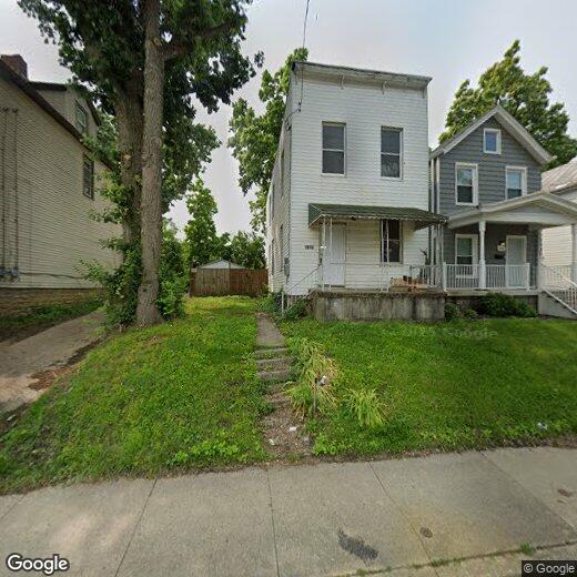
1913 Sherman Ave
Norwood, OH 45212
Today
|
Edit
Favorites
513-374-8419
-
Bedrooms
3
-
Bathrooms
1.25
-
Square Feet
1,700 sq ft
-
Available
Available Now
1913 Sherman Ave

Favorites
About This Home
$1,700 deposit,
Available Now
All new as a new building
1913 Sherman Ave is a house located in Hamilton County and the 45212 ZIP Code. This area is served by the Norwood City attendance zone.
* Price shown is base rent. Excludes user-selected optional fees and variable or usage-based fees and required charges due at or prior to move-in or at move-out. Price, availability, fees, and any applicable rent special are subject to change without notice.
* Square footage definitions vary. Displayed square footage is approximate.
Fees and Policies
The fees below are based on community-supplied data and may exclude additional fees and utilities.
- One-Time Basics
- Due at Move-In
- Security Deposit - RefundableCharged per unit.$1,700
- Due at Move-In
- Dogs
- Allowed
- Cats
- Allowed
Property Fee Disclaimer: Based on community-supplied data and independent market research. Subject to change without notice. May exclude fees for mandatory or optional services and usage-based utilities.
Contact
- Listed by 1913
- Phone Number
- Contact
Location
Get Directions
Norwood was one of the earliest suburbs to form around Cincinnati. Once a hub of industry and innovation thanks to the railroads and nearby metropolis that fed the area, Norwood is now a picturesque enclave that attracts renters of all types.
The city of Norwood has a number of historical landmarks that contribute to the overall identity of the area. The Norwood Mound is a centuries old Native American burial ground that stands as the highest point in the area. Vineyard Central is a gorgeous 114-year-old Catholic church near the downtown district that still hosts a congregation. There are other great local spots to experience the city, not just landmarks. Grab a drink at The Wood, a popular neighborhood bar, or try Bluebird Restaurant, a classic American diner.
There are plenty of parks and golf courses around Norwood if you’re looking for fresh air. Commuters will appreciate the nearby I-71 that makes a drive to Cincinnati a breeze.
Learn more about living in Norwood
Education
| Colleges & Universities | Distance | ||
|---|---|---|---|
| Colleges & Universities | Distance | ||
| Drive: | 5 min | 1.5 mi | |
| Drive: | 10 min | 3.7 mi | |
| Drive: | 10 min | 3.8 mi | |
| Drive: | 15 min | 5.7 mi |
1913 Sherman Ave is within 5 minutes or 1.5 miles from Xavier University. It is also near Univ. of Cincinnati, Medical and University of Cincinnati.
Schools


Public Elementary School
Grades PK-5
236 Students
Nearby
Public Elementary School
Grades PK-5
259 Students
Attendance Zone
Public Middle School
Grades 6-8
395 Students
Attendance Zone
Public High School
Grades 9-12
456 Students
Attendance Zone
Private Elementary & Middle School
Grades PK-8
147 Students
Nearby
Private Elementary, Middle & High School
Grades PK-1, 3-8 & 10
29 Students
Nearby
Private High School
Grades 9-12
36 Students
Nearby
School data provided by
 The GreatSchools Rating helps parents compare schools within a state based on a variety of school quality indicators and provides a helpful picture of how effectively each school serves all of its students. Ratings are on a scale of 1 (below average) to 10 (above average) and can include test scores, college readiness, academic progress, advanced courses, equity, discipline and attendance data. We also advise parents to visit schools, consider other information on school performance and programs, and consider family needs as part of the school selection process.
View GreatSchools Rating Methodology
Data provided by GreatSchools.org © 2025. All rights reserved.
View GreatSchools Rating Methodology
Data provided by GreatSchools.org © 2025. All rights reserved.
Transportation options available in Norwood include Hanke Exchange Station, 12Th & Main, located 5.3 miles from 1913 Sherman Ave. 1913 Sherman Ave is near Cincinnati/Northern Kentucky International, located 19.8 miles or 37 minutes away.
| Transit / Subway | Distance | ||
|---|---|---|---|
| Transit / Subway | Distance | ||
| Drive: | 11 min | 5.3 mi | |
| Drive: | 12 min | 5.5 mi | |
| Drive: | 13 min | 5.7 mi | |
| Drive: | 13 min | 5.9 mi | |
| Drive: | 13 min | 5.9 mi |
| Commuter Rail | Distance | ||
|---|---|---|---|
| Commuter Rail | Distance | ||
|
|
Drive: | 16 min | 7.8 mi |
| Airports | Distance | ||
|---|---|---|---|
| Airports | Distance | ||
|
Cincinnati/Northern Kentucky International
|
Drive: | 37 min | 19.8 mi |
Time and distance from 1913 Sherman Ave.
| Shopping Centers | Distance | ||
|---|---|---|---|
| Shopping Centers | Distance | ||
| Walk: | 11 min | 0.6 mi | |
| Walk: | 14 min | 0.8 mi | |
| Walk: | 21 min | 1.1 mi |
1913 Sherman Ave has 3 shopping centers within 1.1 miles, which is about a 21-minute walk. The miles and minutes will be for the farthest away property.
| Parks and Recreation | Distance | ||
|---|---|---|---|
| Parks and Recreation | Distance | ||
|
Avon Woods Natural Area/Preserve
|
Drive: | 4 min | 1.7 mi |
|
Cincinnati Observatory
|
Drive: | 9 min | 3.5 mi |
|
French Park
|
Drive: | 11 min | 3.6 mi |
|
Ault Park
|
Drive: | 9 min | 3.8 mi |
|
Cincinnati Zoo and Botanical Garden
|
Drive: | 10 min | 4.1 mi |
1913 Sherman Ave has 5 parks within 4.1 miles, including Avon Woods Natural Area/Preserve, Cincinnati Observatory, and Cincinnati Zoo and Botanical Garden.
| Hospitals | Distance | ||
|---|---|---|---|
| Hospitals | Distance | ||
| Drive: | 8 min | 2.5 mi | |
| Drive: | 8 min | 3.0 mi | |
| Drive: | 7 min | 4.0 mi |
1913 Sherman Ave has 3 hospitals within 4.0 miles, the nearest is Blueridge Vista Health and Wellness which is 2.5 miles away and a 8 minute drive.
| Military Bases | Distance | ||
|---|---|---|---|
| Military Bases | Distance | ||
| Drive: | 65 min | 50.0 mi | |
| Drive: | 71 min | 55.0 mi | |
| Drive: | 74 min | 58.3 mi |
1913 Sherman Ave has 3 military bases within 58.3 miles, the nearest is Gentile Air Force Station which is 50.0 miles away and a 65 minute drive.
You May Also Like
Similar Rentals Nearby


What Are Walk Score®, Transit Score®, and Bike Score® Ratings?
Walk Score® measures the walkability of any address. Transit Score® measures access to public transit. Bike Score® measures the bikeability of any address.
What is a Sound Score Rating?
A Sound Score Rating aggregates noise caused by vehicle traffic, airplane traffic and local sources

1913 Sherman Ave
Norwood, OH 45212