
$2,750
/ Month
795 Hylan Blvd Unit 1
Staten Island, NY 10305
2 Weeks Ago
|
Edit
Favorites
HYLAN BOULEVARD

Favorites
Check Back Soon for Upcoming Availability
| Beds | Baths | Average SF |
|---|---|---|
| 2 Bedrooms 2 Bedrooms 2 Br | 1 Bath 1 Bath 1 Ba | — |
About This Property
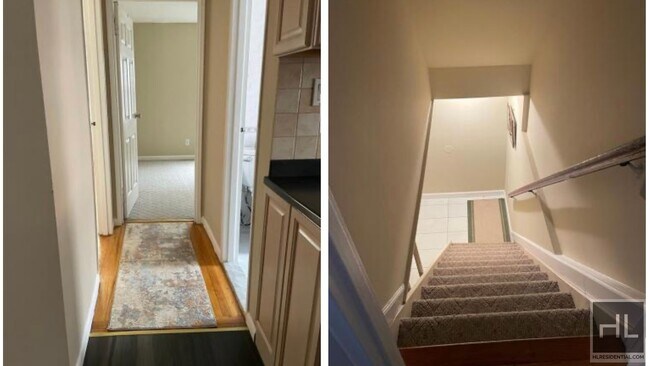
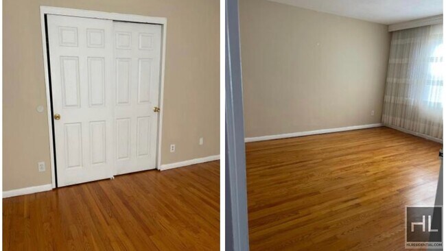
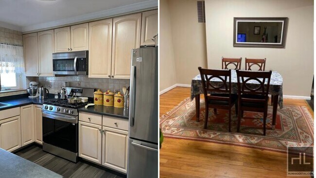
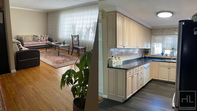
Description coming soon, please contact your Highline Residential agent for more information===Ref:1634866===
HYLAN BOULEVARD is an apartment community located in Richmond County and the 10305 ZIP Code.
795 Hylan Blvd,
Staten Island,
NY
10305
Staten Island occupies a singular position as New York City's southernmost borough, physically separate from the rest of the city yet firmly connected to it through the iconic, round-the-clock Staten Island Ferry. As the least densely populated of the five boroughs, it carries a noticeably quieter, more residential character than Manhattan or Brooklyn, covering roughly 59 square miles with a population near 490,000. The College of Staten Island anchors the borough's educational presence, while Snug Harbor Cultural Center and Botanical Garden reflects a deep commitment to the arts and green space. During the American Revolution, Staten Island served as a primary staging ground for British forces and remained under British control longer than any other part of what would become the United States.
Neighborhoods vary considerably across the island. St. George on the North Shore functions as the civic and cultural hub, while Tottenville anchors the quieter South Shore.
Learn more about living in Staten Island
Education
| Colleges & Universities | Distance | ||
|---|---|---|---|
| Colleges & Universities | Distance | ||
| Drive: | 7 min | 2.2 mi | |
| Drive: | 12 min | 5.5 mi | |
| Drive: | 19 min | 8.4 mi | |
| Drive: | 17 min | 9.5 mi |
HYLAN BOULEVARD is within 7 minutes or 2.2 miles from Wagner College. It is also near Coll. of Staten Island, CUNY and Brooklyn College.
Transportation options available in Staten Island include Bay Ridge-95 Street, located 3.3 miles from HYLAN BOULEVARD. HYLAN BOULEVARD is near Newark Liberty International, located 16.5 miles or 26 minutes away, and John F Kennedy International, located 22.4 miles or 32 minutes away.
| Transit / Subway | Distance | ||
|---|---|---|---|
| Transit / Subway | Distance | ||
|
|
Drive: | 6 min | 3.3 mi |
|
|
Drive: | 6 min | 3.6 mi |
|
|
Drive: | 7 min | 4.1 mi |
|
|
Drive: | 8 min | 4.5 mi |
|
|
Drive: | 8 min | 4.6 mi |
| Commuter Rail | Distance | ||
|---|---|---|---|
| Commuter Rail | Distance | ||
|
|
Walk: | 16 min | 0.8 mi |
|
|
Walk: | 21 min | 1.1 mi |
|
|
Drive: | 4 min | 1.9 mi |
|
|
Drive: | 4 min | 2.0 mi |
|
|
Drive: | 7 min | 2.6 mi |
| Airports | Distance | ||
|---|---|---|---|
| Airports | Distance | ||
|
Newark Liberty International
|
Drive: | 26 min | 16.5 mi |
|
John F Kennedy International
|
Drive: | 32 min | 22.4 mi |
Walkability Near HYLAN BOULEVARD
Getting Around
 What do Walkability, Transit, Drivability, and Bikeability mean?
Walkability measures the walking distance to day-to-day needs.
Transit measures access to public transportation.
Drivability measures congestion, parking availability, and access to major roads.
Bikeability measures the suitability for cycling.
How It Works
What do Walkability, Transit, Drivability, and Bikeability mean?
Walkability measures the walking distance to day-to-day needs.
Transit measures access to public transportation.
Drivability measures congestion, parking availability, and access to major roads.
Bikeability measures the suitability for cycling.
How It Works
Moderately Walkable
Walkability
60
/ 100
Strong Public Transit
Transit
80
/ 100
Very Drivable
Drivability
80
/ 100
Moderately Bikeable
Bikeability
60
/ 100
Scores provided by
-
Soundscore™
-
/ 100
Traffic
-Airport
-Businesses
-Scores provided by
HowLoud What is a Sound Score Rating? A Sound Score Rating aggregates noise caused by vehicle traffic, airplane traffic and local sources. How It WorksTime and distance from HYLAN BOULEVARD.
| Shopping Centers | Distance | ||
|---|---|---|---|
| Shopping Centers | Distance | ||
| Drive: | 3 min | 1.4 mi | |
| Drive: | 4 min | 1.7 mi | |
| Drive: | 7 min | 2.8 mi |
HYLAN BOULEVARD has 3 shopping centers within 2.8 miles, which is about a 7-minute drive. The miles and minutes will be for the farthest away property.
| Parks and Recreation | Distance | ||
|---|---|---|---|
| Parks and Recreation | Distance | ||
|
Ocean Breeze Park
|
Drive: | 4 min | 1.2 mi |
|
Gateway NRA - Staten Island Unit -Fort Wadsworth
|
Drive: | 3 min | 1.3 mi |
|
Alice Austen Park
|
Drive: | 4 min | 1.5 mi |
|
Franklin D. Roosevelt Boardwalk and Beach
|
Drive: | 5 min | 1.8 mi |
|
Silver Lake Park
|
Drive: | 7 min | 3.0 mi |
HYLAN BOULEVARD has 5 parks within 3.0 miles, including Gateway NRA - Staten Island Unit -Fort Wadsworth, Ocean Breeze Park, and Alice Austen Park.
| Hospitals | Distance | ||
|---|---|---|---|
| Hospitals | Distance | ||
| Drive: | 5 min | 1.8 mi | |
| Drive: | 4 min | 2.1 mi | |
| Drive: | 9 min | 3.9 mi |
HYLAN BOULEVARD has 3 hospitals within 3.9 miles, the nearest is South Beach Psychiatric Center which is 1.8 miles away and a 5 minute drive.
| Military Bases | Distance | ||
|---|---|---|---|
| Military Bases | Distance | ||
| Drive: | 7 min | 2.7 mi | |
| Drive: | 8 min | 3.7 mi |
HYLAN BOULEVARD is 2.7 miles from Naval Station NY Stapleton Site, and is convenient to other military bases, including Fort Hamilton.
You May Also Like
Similar Rentals Nearby


What Are Walk Score®, Transit Score®, and Bike Score® Ratings?
Walk Score® measures the walkability of any address. Transit Score® measures access to public transit. Bike Score® measures the bikeability of any address.
What is a Sound Score Rating?
A Sound Score Rating aggregates noise caused by vehicle traffic, airplane traffic and local sources.

795 Hylan Blvd
Staten Island, NY 10305