
The Equestrian At Pelham Parkway
1680 Pelham Pkwy S,
Bronx, NY 10461
$1,850 - $2,900
Studio - 2 Beds
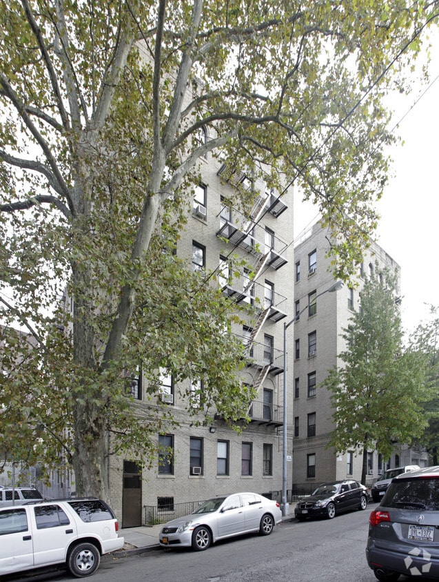
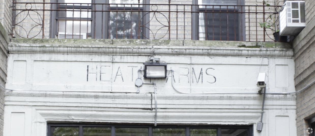
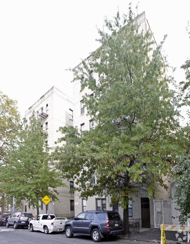

Explore Bronx living at Heath Arms. These apartments are located at 2680 Heath Ave in the 10463 area of Bronx. The professional community team is waiting to show you all that this community has in store. Make a visit to view the available floorplans. So get a head start on your move. Contact or stop by the Heath Arms leasing office to check the current floorplan availability.
Heath Arms is an apartment community located in Bronx County and the 10463 ZIP Code. This area is served by the New York City Geographic District #10 attendance zone.
High Speed Internet Access
Refrigerator
Smoke Free
Heating
Fordham Manor is a densely populated, buzzing neighborhood in the Bronx, home to about 43,000 residents. It includes Fordham University and stretches from Interstate 87 and the Harlem River east to the Bronx Park, home of the Bronx Zoo.
With a history dating back to Colonial times, the oldest section of the neighborhood is Old Fordham Village. Fordham is a fantastic neighborhood with a colorful history. Downtown Manhattan is just eight miles southwest; you'll be able to take the subway or train and get there in less than 30 minutes after moving to your Fordham Manor apartment. Nearby Fordham Road hosts a thriving retail marketplace with over 200 independent and chain stores, attracting plenty of foot traffic throughout the year while keeping the local economy robust.
Learn more about living in Fordham ManorCompare neighborhood and city base rent averages by bedroom.
| Fordham Manor | Bronx, NY | |
|---|---|---|
| Studio | $1,173 | $1,613 |
| 1 Bedroom | $1,386 | $1,636 |
| 2 Bedrooms | $1,692 | $2,098 |
| 3 Bedrooms | $2,403 | $2,358 |
| Colleges & Universities | Distance | ||
|---|---|---|---|
| Colleges & Universities | Distance | ||
| Walk: | 18 min | 1.0 mi | |
| Drive: | 3 min | 1.3 mi | |
| Drive: | 4 min | 1.3 mi | |
| Drive: | 4 min | 1.8 mi |


Transportation options available in Bronx include Marble Hill-225 Street, located 0.5 mile from Heath Arms. Heath Arms is near LaGuardia, located 11.0 miles or 20 minutes away, and Westchester County, located 22.6 miles or 34 minutes away.
| Transit / Subway | Distance | ||
|---|---|---|---|
| Transit / Subway | Distance | ||
|
|
Walk: | 10 min | 0.5 mi |
|
|
Walk: | 12 min | 0.7 mi |
|
|
Walk: | 13 min | 0.7 mi |
|
|
Walk: | 17 min | 0.9 mi |
|
|
Drive: | 2 min | 1.1 mi |
| Commuter Rail | Distance | ||
|---|---|---|---|
| Commuter Rail | Distance | ||
|
|
Walk: | 11 min | 0.6 mi |
|
|
Walk: | 18 min | 1.0 mi |
|
|
Drive: | 3 min | 1.4 mi |
|
|
Drive: | 5 min | 1.9 mi |
|
|
Drive: | 5 min | 2.0 mi |
| Airports | Distance | ||
|---|---|---|---|
| Airports | Distance | ||
|
LaGuardia
|
Drive: | 20 min | 11.0 mi |
|
Westchester County
|
Drive: | 34 min | 22.6 mi |
Scores provided by
Traffic
-Airport
-Businesses
-Scores provided by
HowLoud What is a Sound Score Rating? A Sound Score Rating aggregates noise caused by vehicle traffic, airplane traffic and local sources. How It WorksTime and distance from Heath Arms.
| Shopping Centers | Distance | ||
|---|---|---|---|
| Shopping Centers | Distance | ||
| Walk: | 8 min | 0.4 mi | |
| Walk: | 12 min | 0.6 mi | |
| Walk: | 14 min | 0.7 mi |
| Parks and Recreation | Distance | ||
|---|---|---|---|
| Parks and Recreation | Distance | ||
|
St. James Park
|
Walk: | 15 min | 0.8 mi |
|
Poe Park
|
Walk: | 17 min | 0.9 mi |
|
Dyckman House Park
|
Drive: | 3 min | 1.3 mi |
|
Henry Hudson Park
|
Drive: | 4 min | 1.8 mi |
|
Inwood Hill Park
|
Drive: | 5 min | 2.2 mi |
| Hospitals | Distance | ||
|---|---|---|---|
| Hospitals | Distance | ||
| Drive: | 5 min | 2.2 mi | |
| Drive: | 5 min | 2.5 mi | |
| Drive: | 8 min | 3.5 mi |
| Military Bases | Distance | ||
|---|---|---|---|
| Military Bases | Distance | ||
| Drive: | 23 min | 12.3 mi | |
| Drive: | 32 min | 15.2 mi | |
| Drive: | 37 min | 23.9 mi |

What Are Walk Score®, Transit Score®, and Bike Score® Ratings?
Walk Score® measures the walkability of any address. Transit Score® measures access to public transit. Bike Score® measures the bikeability of any address.
What is a Sound Score Rating?
A Sound Score Rating aggregates noise caused by vehicle traffic, airplane traffic and local sources.

2680 Heath Ave
Bronx, NY 10463


