

$1,940
/ Mes
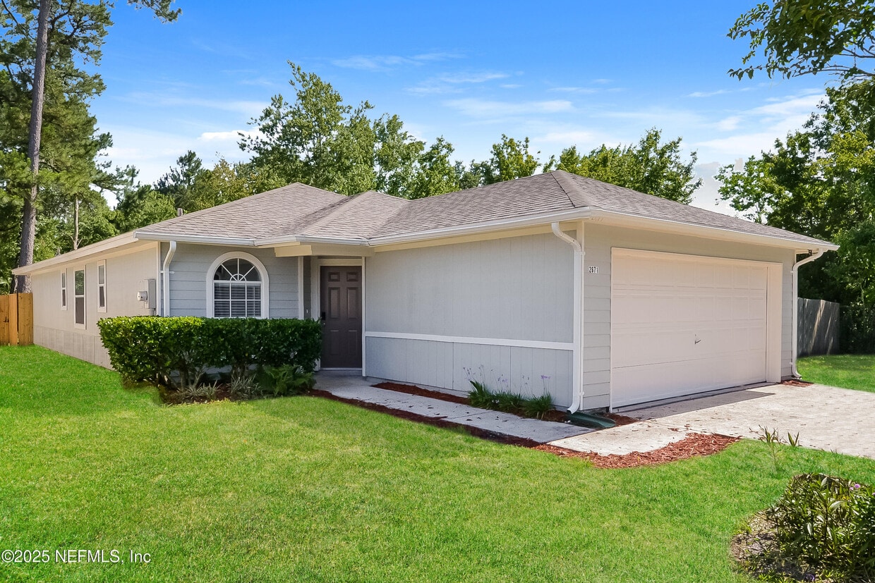
2671 Sam Houston Pl
Jacksonville, FL 32246
Hoy
Favoritos
813-335-6008
-
Habitaciones
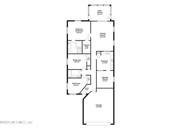
3
-
Baños
2
-
Pies cuadrados
1,425 pies²
-
Disponible
Disponible 19-oct
2671 Sam Houston Pl

Favoritos
Acerca de esta casa
$1,940 depósito,
Disponible 19-oct
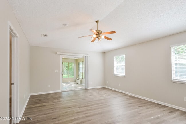
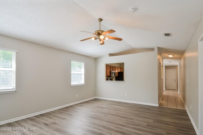
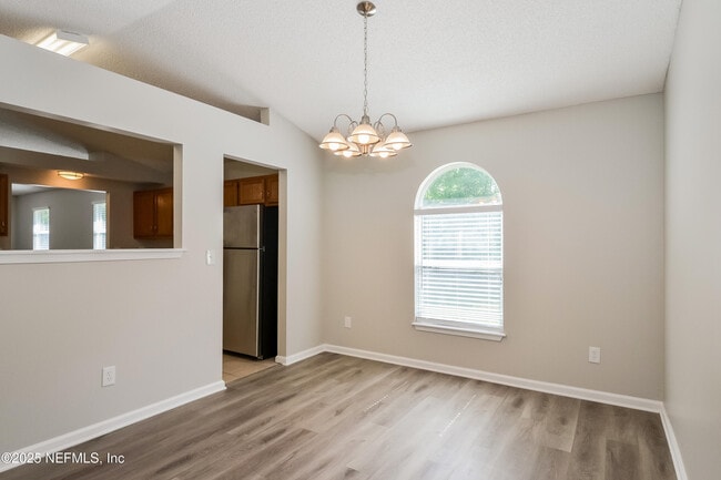
Welcome to your dream home! Step inside this pet-friendly home featuring modern finishings and a layout designed with functionality in mind. Enjoy the storage space found in the kitchen and closets as well as the spacious living areas and natural light throughout. Enjoy outdoor living in your yard,perfect for gathering,relaxing,or gardening! Take advantage of the incredible location,nestled in a great neighborhood with access to schools,parks,dining and more. Don't miss a chance to make this house your next home! Beyond the home,experience the ease of our technology-enabled maintenance services,ensuring hassle-free living at your fingertips. Help is just a tap away! Apply now! MLS# 2106058
2671 Sam Houston Pl se encuentra en Duval County en el código postal 32246. Esta área está atendida por la zona de asistencia del Duval County Public Schools.
* El precio mostrado es el alquiler base. No incluye las tarifas opcionales seleccionadas por el usuario, ni las tarifas variables o basadas en el uso, ni los cargos obligatorios que deben pagarse antes o en el momento de la mudanza, o al momento de la salida. El precio, la disponibilidad, las tarifas y cualquier oferta especial de alquiler aplicable están sujetos a cambios sin previo aviso.
* Las definiciones de la superficie varían. La superficie cuadrada que se muestra es aproximada.
Contactar
- Listado Por DANIEL REYES | Main Street Renewal LLC
- Número de Teléfono
- Contactar
-
Fuente
Northeast Florida Multiple Listing Service, Inc.
Copyright 2025 realMLS. All rights reserved. Information is deemed reliable but not guaranteed.
Ubicación
Obtén las direcciones
Development on the Sandalwood neighborhood began in the spring of 1960. Designed to provide inhabitants with the ideal balance of work and play, Sandalwood sits approximately half way between Jacksonville city center and its nearest beach, which lies roughly six miles east of the neighborhood.
Developer Pearce-Uible's primary Sandalwood concept contained 500 houses. To give the neighborhood an exotic ambiance, Sandalwood's original streets were all named after Pacific Islands. Mindanao Drive, Hawaii Drive East, and Kusai Drive are three of those original roadways. Two more streets, Majuro Drive and Luana Drive, were added to the neighborhood in 1969.
Nearly half the houses in the modern Sandalwood neighborhood are quite new. The original 1960s properties reside in the northern half of the area, whereas newer houses extend to the southern part of the neighborhood. Several educational establishments call the area home, including Sandalwood High School, established in 1971.
Obtén más información sobre la vida en Sandalwood
Educación
| Institutos y Universidades | Distancia de | ||
|---|---|---|---|
| Institutos y Universidades | Dist. | ||
| En coche: | 11 minutos | 7.0 mi | |
| En coche: | 14 minutos | 8.5 mi | |
| En coche: | 17 minutos | 10.1 mi | |
| En coche: | 21 minutos | 13.6 mi |
2671 Sam Houston Pl está a 11 minutos o 7.0 millas de University of North Florida. También está cerca de Jacksonville University et Florida Coastal School of Law.
Escuelas


Escuela primaria pública
Grados PK-5
486 Alumnos
Zona de asistencia
Escuela intermedia pública
Grados 6-8
1,136 Alumnos
Zona de asistencia
Escuela secundaria pública
Grados 9-12
2,771 Alumnos
Zona de asistencia
Escuela primaria, intermedia et secundaria privada
Grados PK-12
221 Alumnos
Propiedades
Escuela primaria, intermedia et secundaria privada
Grados 5-12
56 Alumnos
Propiedades
Datos de escuelas proporcionados por
 La Calificación de GreatSchools ayuda a los padres a comparar las escuelas dentro de un Estado basado en una variedad de indicadores de calidad y proporciona una imagen útil de la eficacia con la que cada escuela sirve a todos sus estudiantes. Las calificaciones están en una escala de 1 (por debajo del promedio) a 10 (encima del promedio) y puede incluir los puntajes de prueba, preparación universitaria, progreso académico, cursos avanzados, equidad, disciplina y datos de asistencia. Nosotros también recomendamos a los padres visitar las escuelas, considerar otra información sobre el desempeño y los programas escolares, y tener en cuenta las necesidades de la familia como parte del proceso de selección de la escuela.
Ver la metodología de calificación de GreatSchools
Datos proporcionados por GreatSchools.org © 2025. Todos los derechos reservados.
Ver la metodología de calificación de GreatSchools
Datos proporcionados por GreatSchools.org © 2025. Todos los derechos reservados.
Las opciones de transporte disponibles en Jacksonville incluyen Kings Ave Station, a 10.0 millas de 2671 Sam Houston Pl. 2671 Sam Houston Pl está cerca de Jacksonville International, a 19.6 millas o 27 minutos de distancia.
| Tránsito / metro | Distancia de | ||
|---|---|---|---|
| Tránsito / metro | Dist. | ||
| En coche: | 19 minutos | 10.0 mi | |
|
|
En coche: | 17 minutos | 10.1 mi |
|
|
En coche: | 19 minutos | 10.2 mi |
|
|
En coche: | 19 minutos | 10.4 mi |
|
|
En coche: | 19 minutos | 10.9 mi |
| Tren suburbano | Distancia de | ||
|---|---|---|---|
| Tren suburbano | Dist. | ||
|
|
En coche: | 25 minutos | 15.8 mi |
| Aeropuertos | Distancia de | ||
|---|---|---|---|
| Aeropuertos | Dist. | ||
|
Jacksonville International
|
En coche: | 27 minutos | 19.6 mi |
Tiempo y distancia desde 2671 Sam Houston Pl.
| Centros comerciales | Distancia de | ||
|---|---|---|---|
| Centros comerciales | Dist. | ||
| En coche: | 4 minutos | 2.2 mi | |
| En coche: | 7 minutos | 4.8 mi | |
| En coche: | 7 minutos | 4.8 mi |
2671 Sam Houston Pl tiene 3 centros comerciales en un radio de 4.8 millas, lo que supone 7 minutos en automóvil. Las millas y los minutos serán para la propiedad más alejada.
| Parques y recreación | Distancia de | ||
|---|---|---|---|
| Parques y recreación | Dist. | ||
|
Jacksonville Arboretum and Gardens
|
En coche: | 7 minutos | 5.4 mi |
|
Tree Hill Nature Center
|
En coche: | 10 minutos | 6.0 mi |
|
Beach and Peach Park
|
En coche: | 10 minutos | 6.6 mi |
|
Touchton Road Park
|
En coche: | 12 minutos | 7.1 mi |
|
Castaway Island Preserve
|
En coche: | 13 minutos | 7.6 mi |
2671 Sam Houston Pl tiene 5 parques en un radio de 7.6 millas, incluyendo Beach and Peach Park, Touchton Road Park, et Jacksonville Arboretum and Gardens.
| Medico | Distancia de | ||
|---|---|---|---|
| Medico | Dist. | ||
| En coche: | 15 minutos | 8.1 mi | |
| En coche: | 14 minutos | 8.8 mi | |
| En coche: | 14 minutos | 10.7 mi |
2671 Sam Houston Pl tiene 3 medico en un radio de 10.7 millas; la más cercana es Memorial Hospital Jacksonville que está a 8.1 millas y a 15 minutos en automóvil.
| Bases militares | Distancia de | ||
|---|---|---|---|
| Bases militares | Dist. | ||
| En coche: | 20 minutos | 12.0 mi | |
| En coche: | 35 minutos | 27.5 mi |
2671 Sam Houston Pl está a 12.0 millas de Mayport Naval Air Station, y está en una ubicación conveniente de otras bases militares, incluyendo Jacksonville Naval Air Station.
También te puede gustar
Alquileres Similares Cercanos


¿Qué son las clasificaciones Walk Score®, Transit Score® y Bike Score®?
Walk Score® mide la viabilidad peatonal de cualquier dirección. Transit Score® mide el acceso a transporte público. Bike Score® mide la infraestructura de rutas para bicicletas de cualquier dirección.
¿Qué es una clasificación de puntaje de ruido?
La clasificación de puntaje de ruido es el conjunto del ruido provocado por el transito de vehículos o de aviones y de fuentes locales.
2671 Sam Houston Pl
Jacksonville, FL 32246