Davis Square

800 Milford Vista Ln, Milford, OH 45150

Share Listing
Favorites
Davis Square
Share Listing
Favorites

Highlights

  • Walk-In Closets
  • Controlled Access
  • Balcony
  • Patio

About Davis Square

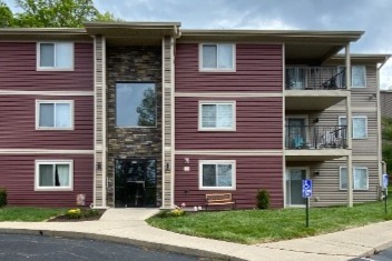
At Davis Square you'll discover spacious floor plans with plenty of trees and open spaces make this Milford community a wonderful place to call home. We're in a great location, just one block from SR 50, with plenty of shopping, entertainment, and restaurants just moments away. Each luxurious 2-bedroom, 2-bath apartment features a foyer with a large balcony or patio, plus spacious walk-in closets and a laundry room adjacent to a fully equipped kitchen. Come see your new home at Davis Square today.

Davis Square is an apartment community located in Clermont County and the 45150 ZIP Code. This area is served by the Milford Exempted Village School District attendance zone.

Community Amenities

Laundry Facilities

Controlled Access

Maintenance on site

Storage Space

  • Laundry Facilities
  • Controlled Access
  • Maintenance on site
  • Storage Space

Apartment Features

Air Conditioning

Dishwasher

Washer/Dryer Hookup

High Speed Internet Access

  • High Speed Internet Access
  • Washer/Dryer Hookup
  • Air Conditioning
  • Heating
  • Ceiling Fans
  • Smoke Free
  • Cable Ready
  • Tub/Shower
  • Dishwasher
  • Kitchen
  • Range
  • Carpet
  • Dining Room
  • Walk-In Closets
  • Window Coverings
  • Balcony
  • Patio
Location
800 Milford Vista Ln, Milford,
OH 45150
Get Directions
City - Milford

Flanked by the Little Miami River, Milford provides a terrific location -- close enough to Downtown Cincinnati that the 15-mile commute is easily tackled, but far enough away to develop its own identity. Milford has a long history, dating back to 1794 when a Revolutionary War veteran built a log cabin in the area. Long before that, it was the location of a Native American Village. The location of the former village is one of Clermont County's largest historical sites: the Gatch Site, which is listed on the National Register of Historic Places. Its 75 acres have yielded some of the region's most important finds, including artifacts, campsites, and burials.

Milford's Main Street offers wide sidewalks, period lighting, historic architecture, and tree-lined streets. Residents can spend the afternoon window-shopping, browsing antiques, or having lunch at one of the cafes.

Learn more about living in Milford 
Education
Colleges & Universities Distance
Drive: 20 min 11.5 mi
Drive: 23 min 11.8 mi
Drive: 28 min 13.8 mi
Drive: 23 min 16.3 mi
Davis Square is within 23 minutes or 11.8 miles from Univ. of Cincinnati, Blue Ash. It is also near Univ. of Cincinnati, Clermont and Xavier University.
Schools
Public Elementary School
Grades K-5
450 Students
Nearby
Public Elementary School
Grades K-5
452 Students
Nearby
Public Elementary School
Grades K-5
331 Students
Nearby
Public Middle & High School
Grades 6-12
1,687 Students
Attendance Zone
Public Middle School
Grades 6-8
941 Students
Nearby
Private Elementary, Middle & High School
Grades PK-12
870 Students
Nearby
Transportation

Davis Square is near Cincinnati/Northern Kentucky International, located 31.8 miles or 47 minutes away.

Commuter Rail Distance
Drive: 34 min 18.3 mi
Airports Distance
Airports Distance
Cincinnati/Northern Kentucky International
Drive: 47 min 31.8 mi

Walkability Near Davis Square

Getting Around
Fairly Walkable
Walkability
50 / 100
Limited Public Transit
Transit
30 / 100
Very Drivable
Drivability
80 / 100
Somewhat Bikeable
Bikeability
30 / 100

Scores provided by

What do Walkability, Transit, Drivability, and Bikeability mean? Walkability measures the walking distance to day-to-day needs. Transit measures access to public transportation. Drivability measures congestion, parking availability, and access to major roads. Bikeability measures the suitability for cycling. How It Works
Active
Soundscore
75 / 100

Traffic

Active

Airport

Calm

Businesses

Active

Scores provided by

HowLoud What is a Sound Score Rating? A Sound Score Rating aggregates noise caused by vehicle traffic, airplane traffic and local sources. How It Works
Points of Interest

Time and distance from Davis Square.

Shopping Centers Distance
Walk: 3 min 0.2 mi
Walk: 4 min 0.2 mi
Walk: 6 min 0.3 mi
Davis Square has 3 shopping centers within 0.3 mile, which is about a 6-minute walk. The miles and minutes will be for the farthest away property.
Parks and Recreation Distance
Little Miami State Park
Drive: 7 min 3.0 mi
Cincinnati Nature Center - Rowe Woods
Drive: 9 min 4.9 mi
Avoca Trailhead
Drive: 12 min 6.0 mi
Rowe Arboretum
Drive: 12 min 6.3 mi
Lake Isabella
Drive: 13 min 7.8 mi
Davis Square has 5 parks within 7.8 miles, including Little Miami State Park, Cincinnati Nature Center - Rowe Woods, and Avoca Trailhead.
Hospitals Distance
Hospitals Distance
Drive: 17 min 8.4 mi
Drive: 13 min 9.6 mi
Drive: 23 min 10.7 mi
Davis Square has 3 hospitals within 10.7 miles, the nearest is The Jewish Hospital - Mercy Health which is 8.4 miles away and a 17 minute drive.
Military Bases Distance
Drive: 68 min 53.8 mi
Drive: 74 min 58.9 mi
Drive: 76 min 62.2 mi
Davis Square has 3 military bases within 62.2 miles, the nearest is Gentile Air Force Station which is 53.8 miles away and a 68 minute drive.

Explore Similar Rentals Nearby