
The Parker 118
118 Park Ave,
Rutherford, NJ 07070
$3,095 - $4,245
1-2 Beds
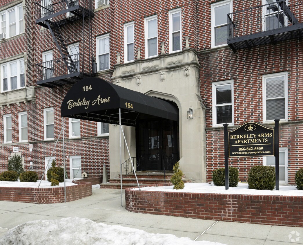
Renovated 1-bedroom apartment available on Union Avenue in Rutherford. Features modern kitchen with butcher-block countertops, shaker cabinets, stylish tile backsplash, stainless steel appliances, and LED lighting. Spacious living room and bedroom. Subway tiled bathroom with black matte fixtures. Original hardwood floors throughout. A truly gorgeous community & historic building with a large laundry room, Amazon Hub locker, outdoor area, and elevator. Pet Friendly with breed restrictions. Fantastic location in Rutherford close to all the shops and restaurants. The building is also a short walk away from the beautiful downtown area of Rutherford. Come see Berkeley Arms and enjoy a community that combines modern needs and a classical style. Resident is responsible electric & gas. 1 year lease only. Pet Friendly with breed restrictions. Verifiable income and credit required. *No Broker Fee*
Berkeley Arms is an apartment community located in Bergen County and the 07070 ZIP Code. This area is served by the Rutherford Public School District attendance zone.
Unique Features
Laundry Facilities
Elevator
24 Hour Access
Property Manager on Site
Air Conditioning
High Speed Internet Access
Hardwood Floors
Refrigerator
Rutherford, New Jersey sits just eight miles from Midtown Manhattan, giving it the energy of a well-connected commuter town without losing the feel of a close-knit borough. The tree-lined streets, historic downtown along Park Avenue, and century-old homes signal a place that takes pride in its character. Residents here enjoy easy access to New York City via NJ Transit's Pascack Valley and Main/Bergen County rail lines, making the commute feel far less daunting than the distance suggests.
The borough draws renters to a range of housing options, from charming Victorian and Colonial-style homes converted into multi-family rentals to well-maintained apartment communities tucked along quiet residential blocks. Newer mid-rise developments have added modern rental inventory near the transit corridors, giving prospective renters a solid mix of architectural styles and price points to consider.
Learn more about living in Rutherford| Colleges & Universities | Distance | ||
|---|---|---|---|
| Colleges & Universities | Distance | ||
| Walk: | 11 min | 0.6 mi | |
| Drive: | 4 min | 2.0 mi | |
| Drive: | 6 min | 2.9 mi | |
| Drive: | 9 min | 3.8 mi |


Transportation options available in Rutherford include Tonnelle Avenue, located 7.0 miles from Berkeley Arms. Berkeley Arms is near Newark Liberty International, located 12.8 miles or 16 minutes away, and LaGuardia, located 22.2 miles or 35 minutes away.
| Transit / Subway | Distance | ||
|---|---|---|---|
| Transit / Subway | Distance | ||
|
|
Drive: | 10 min | 7.0 mi |
|
|
Drive: | 13 min | 8.4 mi |
|
|
Drive: | 14 min | 8.7 mi |
|
|
Drive: | 14 min | 8.7 mi |
|
|
Drive: | 15 min | 10.5 mi |
| Commuter Rail | Distance | ||
|---|---|---|---|
| Commuter Rail | Distance | ||
|
|
Walk: | 9 min | 0.5 mi |
| Drive: | 8 min | 2.1 mi | |
|
|
Drive: | 5 min | 2.3 mi |
|
|
Drive: | 6 min | 2.8 mi |
|
|
Drive: | 6 min | 3.1 mi |
| Airports | Distance | ||
|---|---|---|---|
| Airports | Distance | ||
|
Newark Liberty International
|
Drive: | 16 min | 12.8 mi |
|
LaGuardia
|
Drive: | 35 min | 22.2 mi |
Scores provided by
Traffic
ActiveAirport
CalmBusinesses
BusyScores provided by
HowLoud What is a Sound Score Rating? A Sound Score Rating aggregates noise caused by vehicle traffic, airplane traffic and local sources. How It WorksTime and distance from Berkeley Arms.
| Shopping Centers | Distance | ||
|---|---|---|---|
| Shopping Centers | Distance | ||
| Walk: | 18 min | 0.9 mi | |
| Drive: | 5 min | 1.2 mi | |
| Drive: | 4 min | 1.3 mi |
| Parks and Recreation | Distance | ||
|---|---|---|---|
| Parks and Recreation | Distance | ||
|
Meadowlands Environment Center
|
Drive: | 13 min | 4.8 mi |
|
McDowell Observatory
|
Drive: | 13 min | 4.8 mi |
|
Richard W. DeKorte Park
|
Drive: | 14 min | 7.1 mi |
|
Kearny Marsh
|
Drive: | 12 min | 7.2 mi |
|
Laurel Hill Park
|
Drive: | 13 min | 7.4 mi |
| Hospitals | Distance | ||
|---|---|---|---|
| Hospitals | Distance | ||
| Drive: | 6 min | 3.1 mi | |
| Drive: | 7 min | 4.7 mi | |
| Drive: | 9 min | 5.6 mi |
| Military Bases | Distance | ||
|---|---|---|---|
| Military Bases | Distance | ||
| Drive: | 25 min | 15.1 mi | |
| Drive: | 24 min | 17.3 mi | |
| Drive: | 40 min | 26.8 mi |
What Are Walk Score®, Transit Score®, and Bike Score® Ratings?
Walk Score® measures the walkability of any address. Transit Score® measures access to public transit. Bike Score® measures the bikeability of any address.
What is a Sound Score Rating?
A Sound Score Rating aggregates noise caused by vehicle traffic, airplane traffic and local sources.

154 Union Ave
Rutherford, NJ 07070


