$1,690 / Month
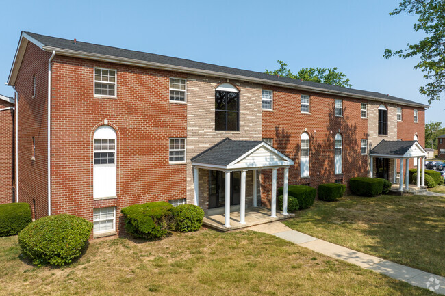
9542 Quarry Bridge Ct
Columbia, MD 21046
2 Weeks Ago
Favorites
9542 Quarry Bridge Ct

Favorites
Check Back Soon for Upcoming Availability
| Beds | Baths | Average SF |
|---|---|---|
| 2 Bedrooms 2 Bedrooms 2 Br | 2 Baths 2 Baths 2 Ba | — |
About This Property
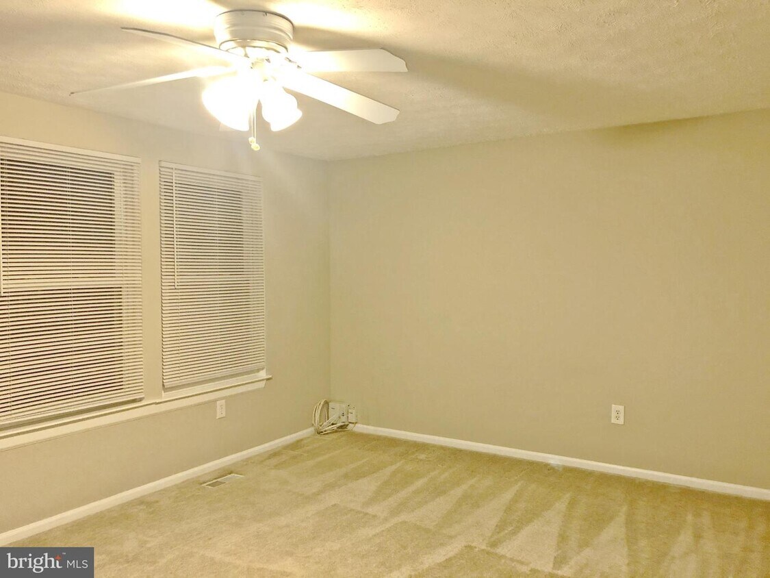
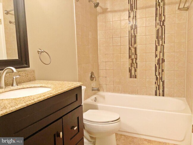
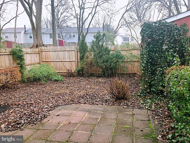
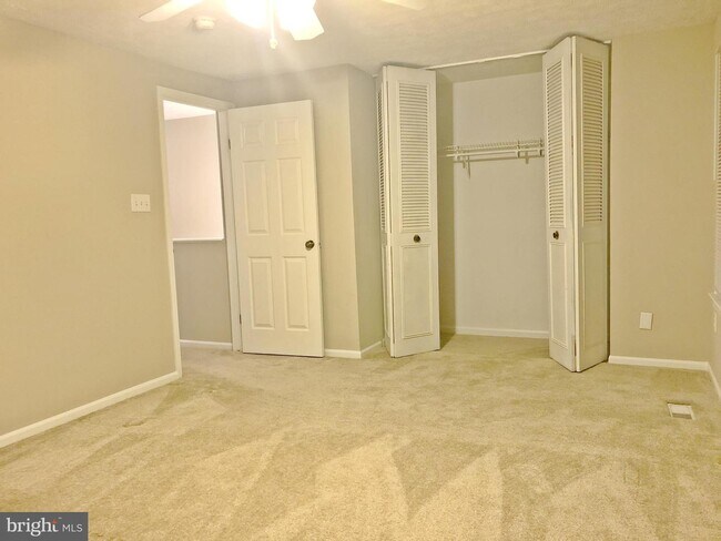
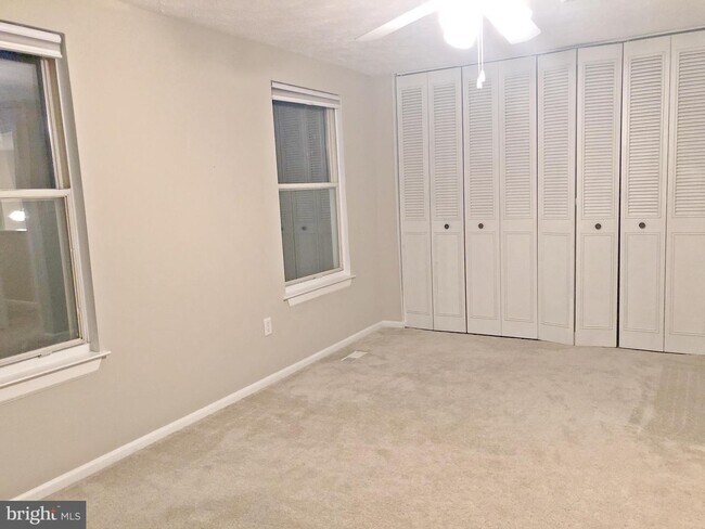
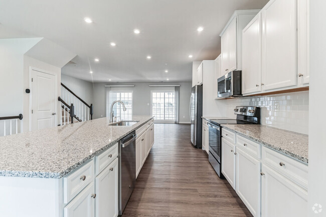
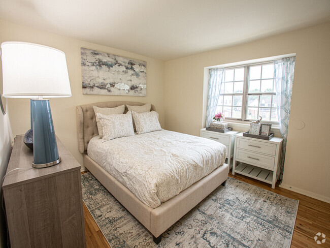
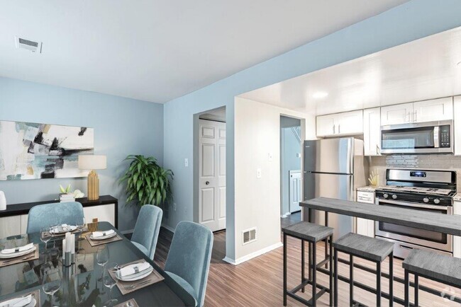
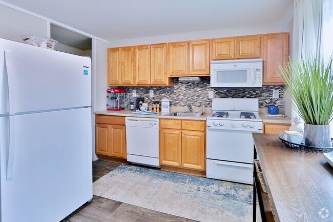
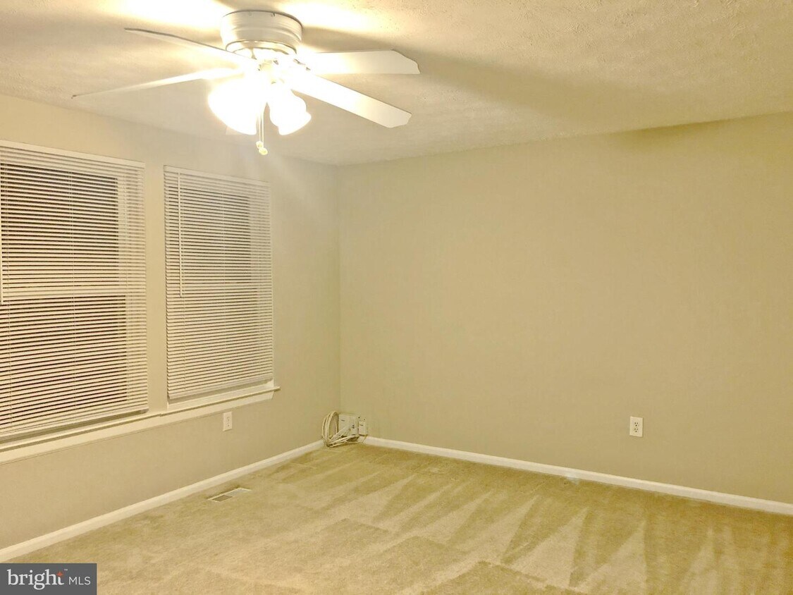
Welcome to this bright & spacious end unit townhouse. 2 large bedrooms, 1.5 bath & large closet. 2 reserved parking. Upgraded kitchen, updated carpet, remodeled full bathroom w/custom tile and granite vanity, fenced-in backyard backing to open space, and extra shed for storage. Easy access to major highways and shopping centers. Professional cleaned the entire house.
9542 Quarry Bridge Ct is a townhome located in Howard County and the 21046 ZIP Code. This area is served by the Howard County Public Schools attendance zone.
Location
Get Directions
Savage-Guilford is a peaceful neighborhood 18 miles south of Baltimore and 25 miles north of Washington, DC between Interstate 95 and Highway 1. Thanks to its ideal location and great amenities, the area attracts commuters and families. Renters will find an array of moderately priced apartments and townhomes that make up the rental scene. Within town, the Middle Patuxent River and Stone Lake provide renters with a variety of water sports as well as parks and trails to explore. Shops and restaurants are scattered throughout the area, but the Historic Savage Mill, a restored cotton mill turned into a trendy shopping mall, is a favorite spot for shopping and dining. Right outside of town, residents have access to more family-friendly fun at the Autobahn Indoor Speedway, Arundel Mills, and parks surrounding the Patuxent River.
Learn more about living in Savage-GuilfordBelow are rent ranges for similar nearby apartments
Education
| Colleges & Universities | Distance | ||
|---|---|---|---|
| Colleges & Universities | Distance | ||
| Drive: | 12 min | 5.4 mi | |
| Drive: | 21 min | 12.2 mi | |
| Drive: | 21 min | 12.7 mi | |
| Drive: | 28 min | 15.3 mi |
9542 Quarry Bridge Ct is within 12 minutes or 5.4 miles from Howard Community College. It is also near CCBC Cantonsville and UMBC.
Schools


Public Elementary School
Grades PK-5
478 Students
Attendance Zone
Public Middle School
Grades 6-8
598 Students
Attendance Zone
Public High School
Grades 9-12
1,287 Students
Attendance Zone
Private Elementary, Middle & High School
Grades 3-12
75 Students
Nearby
Private Elementary, Middle & High School
Grades 4-11
71 Students
Nearby
Private Elementary, Middle & High School
Grades PK-10
181 Students
Nearby
Private Elementary & Middle School
Grades PK-8
248 Students
Nearby
School data provided by
 The GreatSchools Rating helps parents compare schools within a state based on a variety of school quality indicators and provides a helpful picture of how effectively each school serves all of its students. Ratings are on a scale of 1 (below average) to 10 (above average) and can include test scores, college readiness, academic progress, advanced courses, equity, discipline and attendance data. We also advise parents to visit schools, consider other information on school performance and programs, and consider family needs as part of the school selection process.
View GreatSchools Rating Methodology
View GreatSchools Rating Methodology
Transportation options available in Columbia include Dorsey, located 7.4 miles from 9542 Quarry Bridge Ct. 9542 Quarry Bridge Ct is near Baltimore/Washington International Thurgood Marshall, located 14.9 miles or 23 minutes away, and Ronald Reagan Washington Ntl, located 32.0 miles or 52 minutes away.
| Transit / Subway | Distance | ||
|---|---|---|---|
| Transit / Subway | Distance | ||
|
|
Drive: | 15 min | 7.4 mi |
|
|
Drive: | 23 min | 15.0 mi |
|
Bwi Airport
|
Drive: | 24 min | 15.2 mi |
|
|
Drive: | 25 min | 15.9 mi |
| Commuter Rail | Distance | ||
|---|---|---|---|
| Commuter Rail | Distance | ||
|
|
Drive: | 10 min | 4.4 mi |
|
|
Drive: | 12 min | 4.9 mi |
|
|
Drive: | 12 min | 5.4 mi |
|
|
Drive: | 12 min | 5.6 mi |
|
Muirkirk
|
Drive: | 18 min | 9.5 mi |
| Airports | Distance | ||
|---|---|---|---|
| Airports | Distance | ||
|
Baltimore/Washington International Thurgood Marshall
|
Drive: | 23 min | 14.9 mi |
|
Ronald Reagan Washington Ntl
|
Drive: | 52 min | 32.0 mi |
Time and distance from 9542 Quarry Bridge Ct.
| Shopping Centers | Distance | ||
|---|---|---|---|
| Shopping Centers | Distance | ||
| Drive: | 4 min | 1.4 mi | |
| Drive: | 5 min | 2.0 mi | |
| Drive: | 6 min | 2.1 mi |
9542 Quarry Bridge Ct has 3 shopping centers within 2.1 miles, which is about a 6-minute drive. The miles and minutes will be for the farthest away property.
| Parks and Recreation | Distance | ||
|---|---|---|---|
| Parks and Recreation | Distance | ||
|
Clark's Elioak Farm
|
Drive: | 16 min | 8.4 mi |
|
Patuxent Research Refuge - North Tract
|
Drive: | 19 min | 9.2 mi |
|
Benjamin Banneker Historical Park and Museum
|
Drive: | 23 min | 10.5 mi |
|
Browns Bridge Recreation Area
|
Drive: | 20 min | 10.9 mi |
|
Fairland Regional Park
|
Drive: | 18 min | 11.3 mi |
9542 Quarry Bridge Ct has 5 parks within 11.3 miles, including Clark's Elioak Farm, Patuxent Research Refuge - North Tract, and Browns Bridge Recreation Area.
| Hospitals | Distance | ||
|---|---|---|---|
| Hospitals | Distance | ||
| Drive: | 13 min | 5.9 mi | |
| Drive: | 17 min | 8.3 mi | |
| Drive: | 24 min | 14.3 mi |
9542 Quarry Bridge Ct has 3 hospitals within 14.3 miles, the nearest is Howard County General Hospital which is 5.9 miles away and a 13 minute drive.
| Military Bases | Distance | ||
|---|---|---|---|
| Military Bases | Distance | ||
| Drive: | 17 min | 9.0 mi |
9542 Quarry Bridge Ct is 9.0 miles and a 17 minute drive from Fort George Meade.
You May Also Like
Similar Rentals Nearby


What Are Walk Score®, Transit Score®, and Bike Score® Ratings?
Walk Score® measures the walkability of any address. Transit Score® measures access to public transit. Bike Score® measures the bikeability of any address.
What is a Sound Score Rating?
A Sound Score Rating aggregates noise caused by vehicle traffic, airplane traffic and local sources
9542 Quarry Bridge Ct
Columbia, MD 21046