
The Equestrian At Pelham Parkway
1680 Pelham Pkwy S,
Bronx, NY 10461
$1,850 - $2,900
Studio - 2 Beds
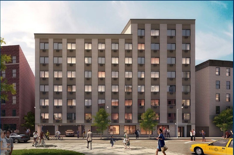
At 915 Dawson Street, discover brand-new studio, one-bedroom, and two-bedroom apartments filled with natural light from double exposure windows. Enjoy spacious living areas and bedrooms with high ceilings, air-conditioning, exquisite hardwood floors offer, and ample closet space. Amenities include bicycle storage, on-site management, and an elevator. Conveniently located near grocery stores, parks, a post office, gym, and restaurants. Just 2 blocks from MTA subway lines 2 and 5 at Intervale Avenue station. Contact the property manager for a virtual tour today! As a resident you can access online rent payment, maintenance requests, and community updates securely through the Resident Portal.
915 Dawson Street, LLC is an apartment community located in Bronx County and the 10459 ZIP Code. This area is served by the New York City Geographic District # 8 attendance zone.
Unique Features
Nestled beside the iconic South Bronx, Woodstock is a quintessential Bronx neighborhood. Woodstock features classic brownstones and newer developments like modern condos at a variety of price points; but similar to other New York neighborhoods, many rentals lean towards the expensive end. Bodegas, specialty shops, and diverse restaurants line the streets, providing the ultimate urban living experience. Woodstock has several playgrounds and schools that serve the area, including elementary, middle, and high schools. Several neighborhood parks dot the landscape, and baseball fans live just two miles away from Yankee Stadium. The neighborhood has several subway stations and transit stops, making traveling across New York City easier. Great for out-of-state trips, LaGuardia Airport is about 10 miles away.
Learn more about living in WoodstockCompare neighborhood and city base rent averages by bedroom.
| Woodstock | Bronx, NY | |
|---|---|---|
| Studio | - | $1,616 |
| 1 Bedroom | $1,602 | $1,636 |
| 2 Bedrooms | $1,485 | $2,096 |
| 3 Bedrooms | $1,127 | $2,357 |
| Colleges & Universities | Distance | ||
|---|---|---|---|
| Colleges & Universities | Distance | ||
| Drive: | 5 min | 2.0 mi | |
| Drive: | 10 min | 3.5 mi | |
| Drive: | 10 min | 3.8 mi | |
| Drive: | 9 min | 5.2 mi |


Transportation options available in Bronx include Intervale Avenue, located 0.1 mile from 915 Dawson Street, LLC. 915 Dawson Street, LLC is near LaGuardia, located 7.4 miles or 15 minutes away, and John F Kennedy International, located 18.4 miles or 27 minutes away.
| Transit / Subway | Distance | ||
|---|---|---|---|
| Transit / Subway | Distance | ||
|
|
Walk: | 2 min | 0.1 mi |
|
|
Walk: | 6 min | 0.3 mi |
|
|
Walk: | 6 min | 0.3 mi |
|
|
Walk: | 7 min | 0.4 mi |
|
|
Walk: | 7 min | 0.4 mi |
| Commuter Rail | Distance | ||
|---|---|---|---|
| Commuter Rail | Distance | ||
|
|
Drive: | 5 min | 1.5 mi |
|
|
Drive: | 6 min | 2.6 mi |
|
|
Drive: | 7 min | 3.6 mi |
|
|
Drive: | 7 min | 3.8 mi |
| Drive: | 9 min | 5.5 mi |
| Airports | Distance | ||
|---|---|---|---|
| Airports | Distance | ||
|
LaGuardia
|
Drive: | 15 min | 7.4 mi |
|
John F Kennedy International
|
Drive: | 27 min | 18.4 mi |
Scores provided by
Traffic
-Airport
-Businesses
-Scores provided by
HowLoud What is a Sound Score Rating? A Sound Score Rating aggregates noise caused by vehicle traffic, airplane traffic and local sources. How It WorksTime and distance from 915 Dawson Street, LLC.
| Shopping Centers | Distance | ||
|---|---|---|---|
| Shopping Centers | Distance | ||
| Walk: | 20 min | 1.0 mi | |
| Drive: | 3 min | 1.4 mi |
| Parks and Recreation | Distance | ||
|---|---|---|---|
| Parks and Recreation | Distance | ||
|
Captain Rivera Playground
|
Walk: | 12 min | 0.6 mi |
|
Concrete Plant Park
|
Walk: | 22 min | 1.1 mi |
|
Barretto Point Park
|
Drive: | 3 min | 1.2 mi |
|
St. Mary's Park
|
Drive: | 3 min | 1.3 mi |
|
Starlight Park
|
Drive: | 4 min | 1.4 mi |
| Hospitals | Distance | ||
|---|---|---|---|
| Hospitals | Distance | ||
| Drive: | 4 min | 1.3 mi | |
| Drive: | 4 min | 1.7 mi | |
| Drive: | 9 min | 3.2 mi |
| Military Bases | Distance | ||
|---|---|---|---|
| Military Bases | Distance | ||
| Drive: | 17 min | 8.8 mi | |
| Drive: | 28 min | 14.0 mi | |
| Drive: | 39 min | 26.0 mi |
What Are Walk Score®, Transit Score®, and Bike Score® Ratings?
Walk Score® measures the walkability of any address. Transit Score® measures access to public transit. Bike Score® measures the bikeability of any address.
What is a Sound Score Rating?
A Sound Score Rating aggregates noise caused by vehicle traffic, airplane traffic and local sources.

915 Dawson St
Bronx, NY 10459


