

$4,300 / Month
91 Viles St
Weston, MA 02493
2 Weeks Ago
Favorites
91 Viles St

Favorites
Check Back Soon for Upcoming Availability
| Beds | Baths | Average SF |
|---|---|---|
| 5 Bedrooms 5 Bedrooms 5 Br | 3.5 Baths 3.5 Baths 3.5 Ba | — |
Fees and Policies
The fees below are based on community-supplied data and may exclude additional fees and utilities.
Pet policies are negotiable.
Details
Utilities Included
-
Water
About This Property
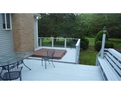
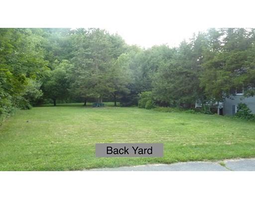
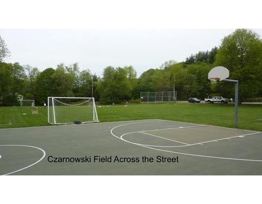
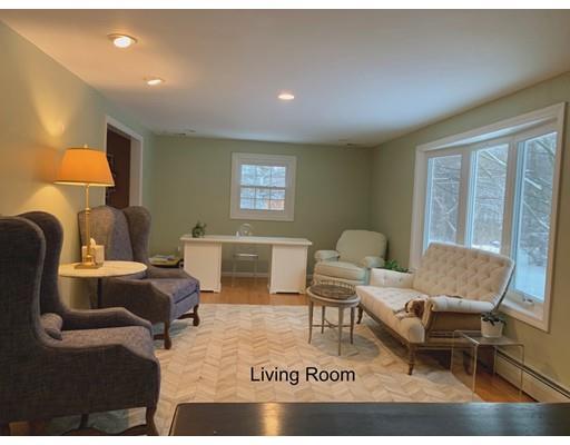
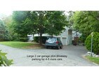
Spacious 10-room, 3-5 bedroom, 3.5 bath house in very popular Brook Road neighborhood, with possible au pair suite. New kitchen with cherry cabinets, granite counters and new appliances, open to large family room with cathedral ceiling and skylight, and sun-filled breakfast room. Three new full bathrooms. Hardwood floors and central air conditioning. Large deck overlooking nice back yard. Across from large field where neighborhood children (and adults) play soccer, baseball and basketball. 2-minute walk to conservation trails. Landscaper for lawn mowing, leaves and cleanup. Ariens Snowblower provided. Short walk to commuter train to Cambridge and Boston. Convenient to 117, 128 and the Mass Pike. Excellent Weston schools, bus stop 20 yards from end of driveway. Please contact owner for rental information and appointments.
91 Viles St is a house located in Middlesex County and the 02493 ZIP Code. This area is served by the Weston attendance zone.
House Features
Air Conditioning
Dishwasher
Microwave
Refrigerator
- Air Conditioning
- Fireplace
- Dishwasher
- Disposal
- Microwave
- Range
- Refrigerator
- Walking/Biking Trails
- Deck
- Garden
Location
Get Directions
Just west of Boston and East of Worcester sits Metro West, a region that houses a group of towns and cities with significant historical backgrounds. A total of 19 municipalities make up the core of this community, but other municipalities are considered to be a part of the Interstate 495/Metro West Corridor.
Learn more about living in Metro WestBelow are rent ranges for similar nearby apartments
| Beds | Average Size | Lowest | Typical | Premium |
|---|---|---|---|---|
| Studio Studio Studio | 526-529 Sq Ft | $1,400 | $2,464 | $8,050 |
| 1 Bed 1 Bed 1 Bed | 872-873 Sq Ft | $1,250 | $3,031 | $10,533 |
| 2 Beds 2 Beds 2 Beds | 1256-1259 Sq Ft | $1,900 | $3,690 | $13,181 |
| 3 Beds 3 Beds 3 Beds | 1677-1681 Sq Ft | $2,000 | $4,759 | $15,246 |
| 4 Beds 4 Beds 4 Beds | 3346 Sq Ft | $1,075 | $6,667 | $17,000 |
Amenities
- Air Conditioning
- Fireplace
- Dishwasher
- Disposal
- Microwave
- Range
- Refrigerator
- Deck
- Garden
- Walking/Biking Trails
Expenses
Utilities Included
Water
Included
Education
| Colleges & Universities | Distance | ||
|---|---|---|---|
| Colleges & Universities | Distance | ||
| Drive: | 9 min | 3.8 mi | |
| Drive: | 10 min | 4.8 mi | |
| Drive: | 18 min | 9.4 mi | |
| Drive: | 19 min | 9.8 mi |
91 Viles St is within 9 minutes or 3.8 miles from Brandeis University. It is also near Bentley University and Babson College.
Schools


Public Elementary School
Grades 4-5
266 Students
Attendance Zone
Public Elementary School
Grades PK-3
331 Students
Attendance Zone
Public Middle School
Grades 6-8
444 Students
Attendance Zone
Public High School
Grades 9-12
639 Students
Attendance Zone
Private Elementary & Middle School
Grades PK-8
320 Students
Nearby
Private Elementary, Middle & High School
Grades 3-12
73 Students
Nearby
Private Elementary, Middle & High School
Grades 3-12
107 Students
Nearby
Private High School
Grades 9-12
329 Students
Nearby
School data provided by
 The GreatSchools Rating helps parents compare schools within a state based on a variety of school quality indicators and provides a helpful picture of how effectively each school serves all of its students. Ratings are on a scale of 1 (below average) to 10 (above average) and can include test scores, college readiness, academic progress, advanced courses, equity, discipline and attendance data. We also advise parents to visit schools, consider other information on school performance and programs, and consider family needs as part of the school selection process.
View GreatSchools Rating Methodology
Data provided by GreatSchools.org © 2025. All rights reserved.
View GreatSchools Rating Methodology
Data provided by GreatSchools.org © 2025. All rights reserved.
Transportation options available in Weston include Riverside, located 6.0 miles from 91 Viles St. 91 Viles St is near General Edward Lawrence Logan International, located 17.1 miles or 30 minutes away, and Worcester Regional, located 41.9 miles or 60 minutes away.
| Transit / Subway | Distance | ||
|---|---|---|---|
| Transit / Subway | Distance | ||
| Drive: | 12 min | 6.0 mi | |
| Drive: | 11 min | 6.5 mi | |
| Drive: | 13 min | 7.2 mi | |
| Drive: | 15 min | 8.7 mi | |
| Drive: | 15 min | 9.0 mi |
| Commuter Rail | Distance | ||
|---|---|---|---|
| Commuter Rail | Distance | ||
| Walk: | 16 min | 0.9 mi | |
| Drive: | 3 min | 1.5 mi | |
| Drive: | 7 min | 3.4 mi | |
| Drive: | 6 min | 3.4 mi | |
| Drive: | 7 min | 3.8 mi |
| Airports | Distance | ||
|---|---|---|---|
| Airports | Distance | ||
|
General Edward Lawrence Logan International
|
Drive: | 30 min | 17.1 mi |
|
Worcester Regional
|
Drive: | 60 min | 41.9 mi |
Time and distance from 91 Viles St.
| Shopping Centers | Distance | ||
|---|---|---|---|
| Shopping Centers | Distance | ||
| Drive: | 5 min | 2.3 mi | |
| Drive: | 5 min | 2.4 mi | |
| Drive: | 8 min | 2.9 mi |
91 Viles St has 3 shopping centers within 2.9 miles, which is about a 8-minute drive. The miles and minutes will be for the farthest away property.
| Parks and Recreation | Distance | ||
|---|---|---|---|
| Parks and Recreation | Distance | ||
|
Land's Sake Farm
|
Drive: | 6 min | 2.7 mi |
|
Mass Audubon's Drumlin Farm Wildlife Sanctuary
|
Drive: | 5 min | 3.2 mi |
|
Codman Community Farms
|
Drive: | 6 min | 3.3 mi |
|
Hazel Brook Conservation Area
|
Drive: | 11 min | 5.2 mi |
|
Upper Mill Brook Conservation Area
|
Drive: | 11 min | 5.8 mi |
91 Viles St has 5 parks within 5.8 miles, including Land's Sake Farm, Mass Audubon's Drumlin Farm Wildlife Sanctuary, and Codman Community Farms.
| Hospitals | Distance | ||
|---|---|---|---|
| Hospitals | Distance | ||
| Drive: | 6 min | 3.1 mi | |
| Drive: | 11 min | 5.9 mi | |
| Drive: | 10 min | 6.2 mi |
91 Viles St has 3 hospitals within 6.2 miles, the nearest is Walden Behavioral Care which is 3.1 miles away and a 6 minute drive.
| Military Bases | Distance | ||
|---|---|---|---|
| Military Bases | Distance | ||
| Drive: | 18 min | 8.6 mi | |
| Drive: | 19 min | 10.2 mi |
91 Viles St is 8.6 miles from Hanscom Air Force Base, and is convenient to other military bases, including US Military Reservation.
You May Also Like
Similar Rentals Nearby


What Are Walk Score®, Transit Score®, and Bike Score® Ratings?
Walk Score® measures the walkability of any address. Transit Score® measures access to public transit. Bike Score® measures the bikeability of any address.
What is a Sound Score Rating?
A Sound Score Rating aggregates noise caused by vehicle traffic, airplane traffic and local sources
91 Viles St
Weston, MA 02493