

$8,000 / Month
9 Rosegate Rd
Needham, MA 02494
Today
Favorites
781-771-5572
-
Bedrooms
4
-
Bathrooms
3.5
-
Square Feet
4,767 sq ft
-
Available
Available Now
Highlights
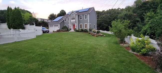
- Patio
- Fenced Lot
9 Rosegate Rd

Favorites
About This Home
$8,000 deposit,
Available Now
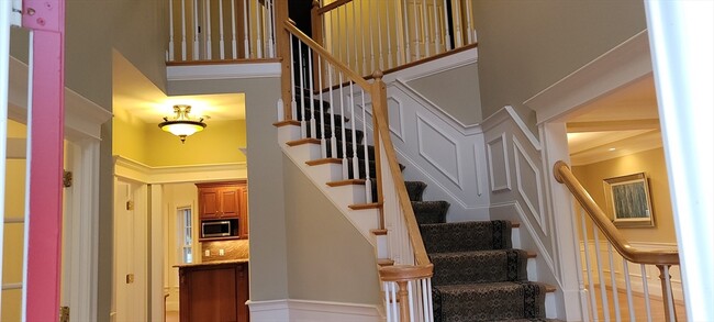
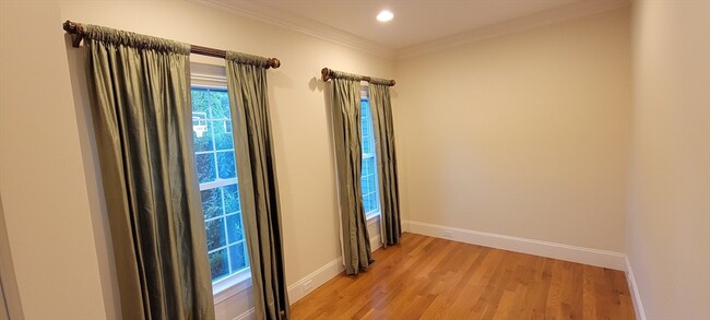
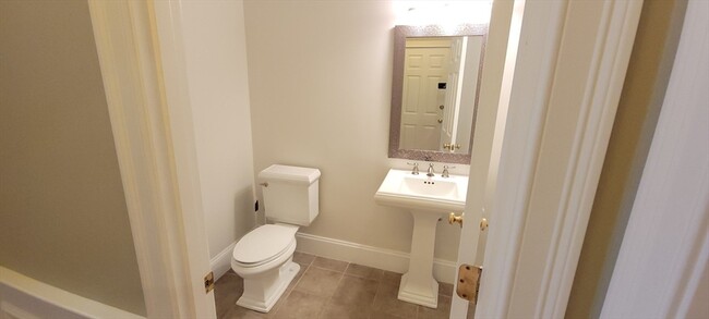
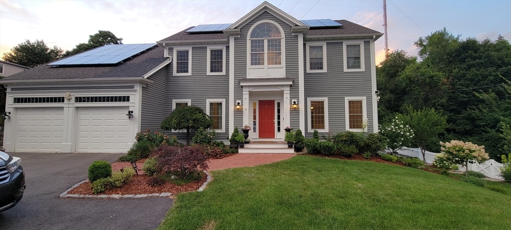
Truly a fantastic location in Needham Heights! This lovely Colonial home offers 4-5 Bedrooms,3.5 baths with all of your traditional formal areas; living room,dining room and a beautiful family area with cathedral ceilings located off of the gourmet kitchen! The kitchen offers a Subzero refrigerator,Wolf oven,granite island & seating area overlooking the beautiful side yard! Entering into the front entryway to the left are French doors to an office,to the right is the formal living & dining area w beautiful pillars and tray ceilings! Upstairs offers a spacious master bedroom with master bath,double sinks,jet spa tub,shower,walk in custom built closet as well as a bonus room w custom flooring. The lower level has a brand new custom kitchen,bonus room w full bathroom,exercise/office and theatre/media room! This lovely home is located in a sought after cul-de-sac nearby to rte 128,Needham Street & many major routes! Professional landscaping & solar panels included! MLS# 73359609
9 Rosegate Rd is a house located in Norfolk County and the 02494 ZIP Code. This area is served by the Needham attendance zone.
* Price shown is base rent and may not include non-optional fees and utilities.
Price, availability, fees, and any applicable rent special are subject to change without notice.
* Square footage definitions vary. Displayed square footage is approximate.
Home Details
Home Type
Single Family Detached Home
Year Built
Built in 2005 | Remodeled
Accessible Home Design
Entry on the 1st floor
Basement
Exterior Basement Entry
Bedrooms and Bathrooms
3.5 Bathrooms
Primary bedroom located on second floor
Separate Shower
4 Bedrooms
Flooring
Engineered Wood
Wall to Wall Carpet
Home Security
Home Security System
Interior Spaces
Open Floorplan
Family Room with Fireplace
Cathedral Ceiling
Bonus Room
Home Office
Dining Area
4,767 Sq Ft Home
Kitchen
Solid Surface Countertops
Country Kitchen
Range
Microwave
Dishwasher
Laundry
Dryer
Laundry on main level
Washer
Listing and Financial Details
Security Deposit $8,000
Property Available on 6/15/25
Assessor Parcel Number 4697554
Rent includes gardener, occupancy only
Lot Details
0.56 Acre Lot
Landscaped Professionally
Fenced Yard
Fenced
Sprinkler System
Outdoor Features
Patio
Parking
2 Car Garage
Schools
Eliot Elementary School
Pollard Middle School
Needham High School
Utilities
Cooling Available
Forced Air Heating System
Electric Baseboard Heater
Heating System Uses Natural Gas
Community Details
Overview
No Home Owners Association
Pet Policy
Call for details about the types of pets allowed
Fees and Policies
The fees below are based on community-supplied data and may exclude additional fees and utilities.
Pet policies are negotiable.
Contact
- Listed by Jodie Zinna | Coldwell Banker Realty - Wellesley
- Phone Number
-
Source
 MLS Property Information Network
The property listing data and information set forth herein were provided to MLS Property Information Network, Inc. from third party sources, including sellers, lessors and public records, and were compiled by MLS Property Information Network, Inc. The property listing data and information are for the personal, non-commercial use of consumers having a good faith interest in purchasing or leasing listed properties of the type displayed to them and may not be used for any purpose other than to identify prospective properties which such consumers may have a good faith interest in purchasing or leasing. MLS Property Information Network, Inc. and its subscribers disclaim any and all representations and warranties as to the accuracy of the property listing data and information set forth herein. All properties are subject to prior sale, change or withdrawal. Copyright © 2025 MLS Property Information Network, Inc. All rights reserved.
Location
Get Directions
Amenities
- Sprinkler System
- Dishwasher
- Disposal
- Microwave
- Range
- Refrigerator
- Fenced Lot
- Patio
Just west of Boston and East of Worcester sits Metro West, a region that houses a group of towns and cities with significant historical backgrounds. A total of 19 municipalities make up the core of this community, but other municipalities are considered to be a part of the Interstate 495/Metro West Corridor.
Learn more about living in Metro West
Education
| Colleges & Universities | Distance | ||
|---|---|---|---|
| Colleges & Universities | Distance | ||
| Drive: | 7 min | 3.3 mi | |
| Drive: | 11 min | 4.4 mi | |
| Drive: | 13 min | 5.4 mi | |
| Drive: | 11 min | 5.5 mi |
9 Rosegate Rd is within 7 minutes or 3.3 miles from Babson College. It is also near Wellesley College and Boston College.
Schools


Public Elementary School
Grades K-5
280 Students
Nearby
Public Elementary & Middle School
Grades 6
446 Students
Attendance Zone
Public Elementary School
Grades K-5
426 Students
Attendance Zone
Public Middle School
Grades 6-8
657 Students
Nearby
Public Middle School
Grades 7-8
818 Students
Attendance Zone
Public High School
Grades 9-12
1,645 Students
Attendance Zone
Private Elementary School
Grades PK-6
174 Students
Nearby
Private Elementary & Middle School
Grades PK-8
353 Students
Nearby
Private Middle & High School
Grades 7-12
9 Students
Nearby
Private Middle School
Grades 6-8
109 Students
Nearby
Private High School
Grades 9-12
10 Students
Nearby
School data provided by
 The GreatSchools Rating helps parents compare schools within a state based on a variety of school quality indicators and provides a helpful picture of how effectively each school serves all of its students. Ratings are on a scale of 1 (below average) to 10 (above average) and can include test scores, college readiness, academic progress, advanced courses, equity, discipline and attendance data. We also advise parents to visit schools, consider other information on school performance and programs, and consider family needs as part of the school selection process.
View GreatSchools Rating Methodology
Data provided by GreatSchools.org © 2025. All rights reserved.
View GreatSchools Rating Methodology
Data provided by GreatSchools.org © 2025. All rights reserved.
Transportation options available in Needham include Waban, located 1.9 miles from 9 Rosegate Rd. 9 Rosegate Rd is near General Edward Lawrence Logan International, located 16.6 miles or 28 minutes away, and Worcester Regional, located 40.8 miles or 60 minutes away.
| Transit / Subway | Distance | ||
|---|---|---|---|
| Transit / Subway | Distance | ||
| Drive: | 5 min | 1.9 mi | |
| Drive: | 5 min | 2.1 mi | |
| Drive: | 5 min | 2.4 mi | |
| Drive: | 6 min | 2.6 mi | |
| Drive: | 8 min | 2.9 mi |
| Commuter Rail | Distance | ||
|---|---|---|---|
| Commuter Rail | Distance | ||
| Walk: | 21 min | 1.1 mi | |
| Drive: | 4 min | 2.1 mi | |
| Drive: | 5 min | 2.6 mi | |
| Drive: | 7 min | 2.7 mi | |
| Drive: | 6 min | 2.8 mi |
| Airports | Distance | ||
|---|---|---|---|
| Airports | Distance | ||
|
General Edward Lawrence Logan International
|
Drive: | 28 min | 16.6 mi |
|
Worcester Regional
|
Drive: | 60 min | 40.8 mi |
Time and distance from 9 Rosegate Rd.
| Shopping Centers | Distance | ||
|---|---|---|---|
| Shopping Centers | Distance | ||
| Drive: | 3 min | 1.5 mi | |
| Drive: | 3 min | 1.6 mi | |
| Drive: | 4 min | 2.0 mi |
9 Rosegate Rd has 3 shopping centers within 2.0 miles, which is about a 4-minute drive. The miles and minutes will be for the farthest away property.
| Parks and Recreation | Distance | ||
|---|---|---|---|
| Parks and Recreation | Distance | ||
|
Hemlock Gorge Reservation
|
Walk: | 16 min | 0.8 mi |
|
Cutler Park Reservation
|
Drive: | 4 min | 2.2 mi |
|
Whitin Observatory
|
Drive: | 10 min | 3.9 mi |
|
Wellesley College Botanic Gardens
|
Drive: | 9 min | 4.2 mi |
|
Hammond Pond Reservation
|
Drive: | 9 min | 4.3 mi |
9 Rosegate Rd has 5 parks within 4.3 miles, including Hemlock Gorge Reservation, Cutler Park Reservation, and Whitin Observatory.
| Hospitals | Distance | ||
|---|---|---|---|
| Hospitals | Distance | ||
| Drive: | 4 min | 2.2 mi | |
| Drive: | 5 min | 2.3 mi | |
| Drive: | 12 min | 5.9 mi |
9 Rosegate Rd has 3 hospitals within 5.9 miles, the nearest is Beth Israel Deaconess Hospital - Needham which is 2.2 miles away and a 4 minute drive.
| Military Bases | Distance | ||
|---|---|---|---|
| Military Bases | Distance | ||
| Drive: | 15 min | 7.1 mi | |
| Drive: | 23 min | 12.5 mi |
9 Rosegate Rd is 7.1 miles from US Military Reservation, and is convenient to other military bases, including Hanscom Air Force Base.
You May Also Like
Similar Rentals Nearby


What Are Walk Score®, Transit Score®, and Bike Score® Ratings?
Walk Score® measures the walkability of any address. Transit Score® measures access to public transit. Bike Score® measures the bikeability of any address.
What is a Sound Score Rating?
A Sound Score Rating aggregates noise caused by vehicle traffic, airplane traffic and local sources
9 Rosegate Rd
Needham, MA 02494