$1,995 / Month
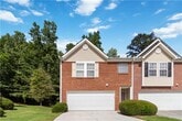
897 Brickleridge Ln SE
Mableton, GA 30126
Today
Favorites
770-265-6203
-
Bedrooms
3
-
Bathrooms
2.5
-
Square Feet
1,512 sq ft
-
Available
Available Jun 15
897 Brickleridge Ln SE

Favorites
About This Home
$1,995 deposit,
Available Jun 15
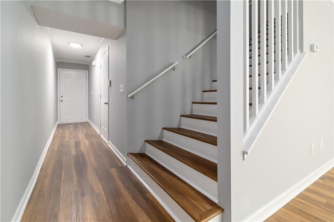
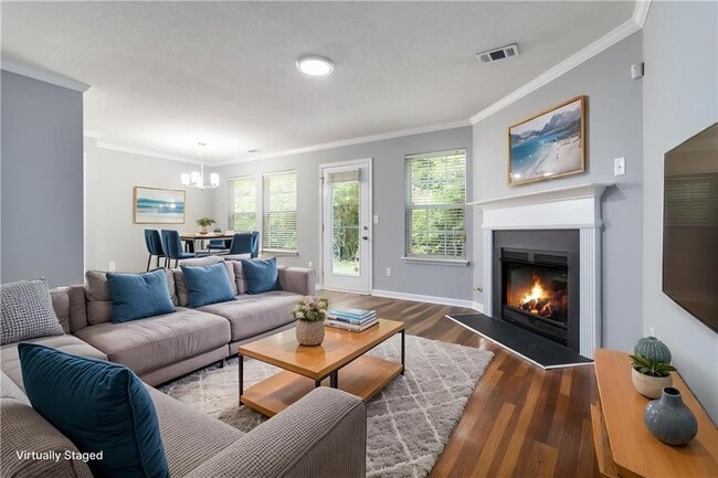
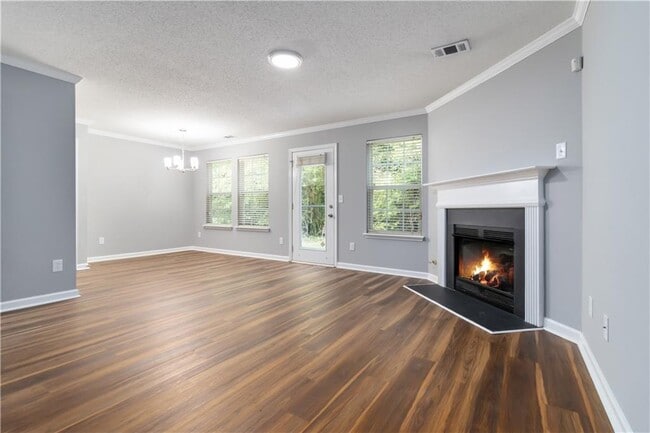
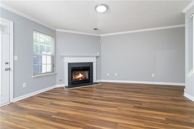
Discover this inviting rental retreat in Mableton,ideally located near I-285,I-20,Downtown Atlanta,Vinings,Smyrna Market Village,The Battery Atlanta,Truist Park,Cumberland Mall,and a variety of top dining and shopping destinations. This charming townhome features a comfortable 3-bedroom,2.5-bath layout with new LVP flooring throughout,a cozy living room with a fireplace,and a versatile loft perfect for a home office or gym. Enjoy a spacious master suite,a 2-car garage,and more. The owner requires a minimum credit score of 650,At least 2 years of steady,verifiable employment,Monthly gross income of at least 3x the rent,No recent collection accounts,rental issues,late payments,foreclosures,evictions,or bankruptcies within the past 3 years. No housing vouchers accepted and no pets allowed per owner's request.
897 Brickleridge Ln SE is a townhome located in Cobb County and the 30126 ZIP Code. This area is served by the Cobb County attendance zone.
* Price shown is base rent and may not include non-optional fees and utilities.
Price, availability, fees, and any applicable rent special are subject to change without notice.
* Square footage definitions vary. Displayed square footage is approximate.
Townhome Features
Dishwasher
Microwave
Refrigerator
Disposal
- Dishwasher
- Disposal
- Microwave
- Range
- Refrigerator
Fees and Policies
The fees below are based on community-supplied data and may exclude additional fees and utilities.
Contact
- Listed by Darrick Dickerson | Keller Williams Realty Cityside
- Phone Number
- Contact
-
Source
 First Multiple Listing Service, Inc.
Copyright © 2025 First Multiple Listing Service, Inc. All rights reserved. All information provided by the listing agent/broker is deemed reliable but is not guaranteed and should be independently verified.
Location
Get Directions
Amenities
- Dishwasher
- Disposal
- Microwave
- Range
- Refrigerator
Nestled in the bustling Cobb County region, Mableton is Metro Atlanta’s largest unincorporated community. Known as one of the biggest up-and-coming areas outside of Atlanta, this city blends small-town charm with modern conveniences. Thanks to a premier location, countless amenities, and a close-knit feel, Mableton has become the ideal place to live for those seeking easy access into the city.
Situated just east of Interstate 285 and north of Interstate 20, the neighborhood features a calm suburban lifestyle minutes from Downtown Atlanta. With a diverse population, excellent schools, and great dining options, Mableton has grown to be one of the most popular locations in the metro area. In addition, locals enjoy the use of the Silver Comet Trail for running or walking.
Learn more about living in Mableton
Education
| Colleges & Universities | Distance | ||
|---|---|---|---|
| Colleges & Universities | Distance | ||
| Drive: | 10 min | 5.1 mi | |
| Drive: | 19 min | 9.5 mi | |
| Drive: | 16 min | 9.9 mi | |
| Drive: | 17 min | 10.3 mi |
897 Brickleridge Ln SE is within 10 minutes or 5.1 miles from Chatt. Tech, Austell. It is also near Clark Atlanta University and Morehouse College.
Schools


Public Elementary School
Grades PK-5
939 Students
Attendance Zone
Public Middle School
Grades 6-8
1,096 Students
Attendance Zone
Public Middle School
Grades 6-8
521 Students
Attendance Zone
Public High School
Grades 9-12
2,511 Students
Attendance Zone
Private Elementary & Middle School
Grades K-8
Nearby
Private Elementary & Middle School
Grades PK-8
Nearby
Private Elementary, Middle & High School
Grades PK-12
852 Students
Nearby
School data provided by
 The GreatSchools Rating helps parents compare schools within a state based on a variety of school quality indicators and provides a helpful picture of how effectively each school serves all of its students. Ratings are on a scale of 1 (below average) to 10 (above average) and can include test scores, college readiness, academic progress, advanced courses, equity, discipline and attendance data. We also advise parents to visit schools, consider other information on school performance and programs, and consider family needs as part of the school selection process.
View GreatSchools Rating Methodology
Data provided by GreatSchools.org © 2025. All rights reserved.
View GreatSchools Rating Methodology
Data provided by GreatSchools.org © 2025. All rights reserved.
Transportation options available in Mableton include Hamilton E Holmes Station, located 6.6 miles from 897 Brickleridge Ln SE. 897 Brickleridge Ln SE is near Hartsfield - Jackson Atlanta International, located 19.3 miles or 30 minutes away.
| Transit / Subway | Distance | ||
|---|---|---|---|
| Transit / Subway | Distance | ||
|
|
Drive: | 12 min | 6.6 mi |
|
|
Drive: | 11 min | 6.9 mi |
|
|
Drive: | 13 min | 7.6 mi |
|
|
Drive: | 15 min | 8.7 mi |
|
|
Drive: | 17 min | 9.4 mi |
| Commuter Rail | Distance | ||
|---|---|---|---|
| Commuter Rail | Distance | ||
|
|
Drive: | 21 min | 11.9 mi |
| Airports | Distance | ||
|---|---|---|---|
| Airports | Distance | ||
|
Hartsfield - Jackson Atlanta International
|
Drive: | 30 min | 19.3 mi |
Time and distance from 897 Brickleridge Ln SE.
| Shopping Centers | Distance | ||
|---|---|---|---|
| Shopping Centers | Distance | ||
| Walk: | 12 min | 0.6 mi | |
| Walk: | 15 min | 0.8 mi | |
| Drive: | 5 min | 2.6 mi |
897 Brickleridge Ln SE has 3 shopping centers within 2.6 miles, which is about a 5-minute walk. The miles and minutes will be for the farthest away property.
| Parks and Recreation | Distance | ||
|---|---|---|---|
| Parks and Recreation | Distance | ||
|
Silver Comet Trail
|
Drive: | 13 min | 6.3 mi |
|
Cascade Springs Nature Preserve
|
Drive: | 14 min | 8.7 mi |
|
West Atlanta Watershed Alliance (WAWA)
|
Drive: | 17 min | 9.3 mi |
|
Atlanta BeltLine Southwest Connector Spur Trail
|
Drive: | 19 min | 10.5 mi |
|
Sweetwater Creek State Park
|
Drive: | 20 min | 11.0 mi |
897 Brickleridge Ln SE has 5 parks within 11.0 miles, including Silver Comet Trail, Atlanta BeltLine Southwest Connector Spur Trail, and Cascade Springs Nature Preserve.
| Hospitals | Distance | ||
|---|---|---|---|
| Hospitals | Distance | ||
| Drive: | 11 min | 5.8 mi | |
| Drive: | 14 min | 7.4 mi | |
| Drive: | 16 min | 9.6 mi |
897 Brickleridge Ln SE has 3 hospitals within 9.6 miles, the nearest is Ridgeview Institute which is 5.8 miles away and a 11 minute drive.
| Military Bases | Distance | ||
|---|---|---|---|
| Military Bases | Distance | ||
| Drive: | 24 min | 11.4 mi | |
| Drive: | 21 min | 12.1 mi |
897 Brickleridge Ln SE is 11.4 miles from Dobbins Air Force Base, and is convenient to other military bases, including Fort McPherson.
You May Also Like
Similar Rentals Nearby


What Are Walk Score®, Transit Score®, and Bike Score® Ratings?
Walk Score® measures the walkability of any address. Transit Score® measures access to public transit. Bike Score® measures the bikeability of any address.
What is a Sound Score Rating?
A Sound Score Rating aggregates noise caused by vehicle traffic, airplane traffic and local sources
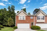
897 Brickleridge Ln SE
Mableton, GA 30126