
$2,500
/ Month
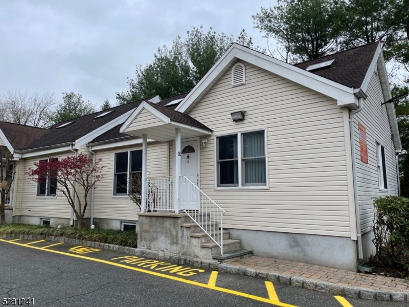
887 Edwards Rd Unit E
Parsippany-Troy Hills, NJ 07054
2 Weeks Ago
|
Edit
Favorites
887 Edwards Rd Unit E

Favorites
Check Back Soon for Upcoming Availability
| Beds | Baths | Average SF |
|---|---|---|
| 2 Bedrooms 2 Bedrooms 2 Br | 1 Bath 1 Bath 1 Ba | — |
Fees and Policies
The fees listed below are community-provided and may exclude utilities or add-ons. All payments are made directly to the property and are non-refundable unless otherwise specified.
About This Property
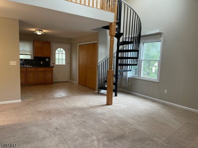
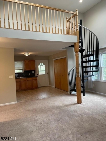
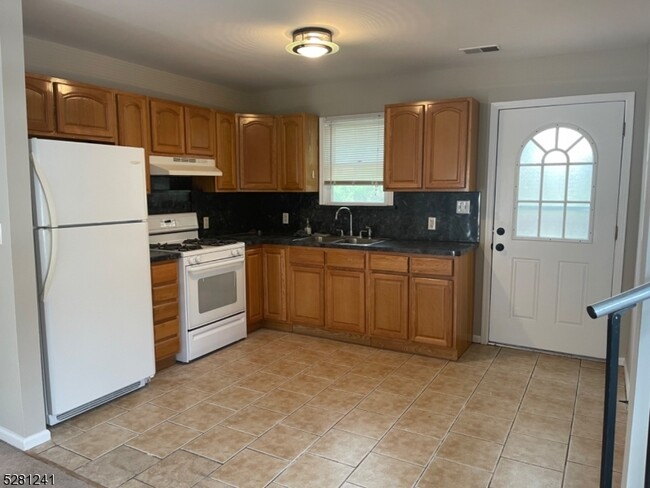
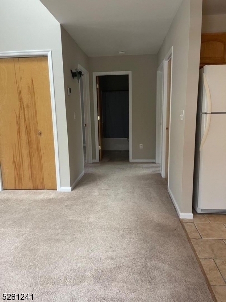
Professionally cleaned carpets and freshly painted. 2BR 1 Full Bath unit. Washer/dryer in unit. Enjoy eating on the deck that's just off the kitchen. Open floor plan with 2 br and 1 bath on first floor. Unit has spiral staircase to office/loft. Immediate availability.
887 Edwards Rd is an apartment community located in Morris County and the 07054 ZIP Code.
Features
- Range
- Carpet
- Deck
887 Edwards Rd,
Parsippany-Troy Hills,
NJ
07054
Parsippany–Troy Hills is the kind of North Jersey place where you can be on I-287 in minutes, yet still end the day near a lake with porch lights flickering on around the shoreline. Big roads knit everything together, so quick runs for groceries, takeout, and everyday basics feel easy, especially around Route 10 and the Route 46 stretch. When you want a breather, the township’s park system spreads across dozens of spots, including larger preserves like Knoll Park, which gives the area a surprisingly green backdrop for such a well-connected hub.
Each section has its own rhythm, from Lake Hiawatha’s neighborhood streets to Mount Tabor’s tucked-away vibe, with Troy Hills and Parsippany Hills offering plenty of quiet pockets between busier corridors.
Learn more about living in Parsippany-Troy Hills
Amenities
- Range
- Carpet
- Deck
Education
| Colleges & Universities | Distance | ||
|---|---|---|---|
| Colleges & Universities | Distance | ||
| Drive: | 12 min | 6.2 mi | |
| Drive: | 20 min | 9.6 mi | |
| Drive: | 19 min | 11.2 mi | |
| Drive: | 20 min | 12.8 mi |
887 Edwards Rd Unit E is within 12 minutes or 6.2 miles from Caldwell College. It is also near Drew University and College of Saint Elizabeth.
Transportation options available in Parsippany-Troy Hills include Grove Street, located 13.2 miles from 887 Edwards Rd Unit E. 887 Edwards Rd Unit E is near Newark Liberty International, located 19.6 miles or 28 minutes away, and LaGuardia, located 36.3 miles or 50 minutes away.
| Transit / Subway | Distance | ||
|---|---|---|---|
| Transit / Subway | Distance | ||
|
|
Drive: | 20 min | 13.2 mi |
| Commuter Rail | Distance | ||
|---|---|---|---|
| Commuter Rail | Distance | ||
|
|
Drive: | 11 min | 6.6 mi |
|
|
Drive: | 14 min | 7.1 mi |
|
|
Drive: | 10 min | 7.2 mi |
|
|
Drive: | 12 min | 8.2 mi |
|
|
Drive: | 15 min | 9.3 mi |
| Airports | Distance | ||
|---|---|---|---|
| Airports | Distance | ||
|
Newark Liberty International
|
Drive: | 28 min | 19.6 mi |
|
LaGuardia
|
Drive: | 50 min | 36.3 mi |
Walkability Near 887 Edwards Rd Parsippany-Troy Hills, NJ 07054
Getting Around
 What do Walkability, Transit, Drivability, and Bikeability mean?
Walkability measures the walking distance to day-to-day needs.
Transit measures access to public transportation.
Drivability measures congestion, parking availability, and access to major roads.
Bikeability measures the suitability for cycling.
How It Works
What do Walkability, Transit, Drivability, and Bikeability mean?
Walkability measures the walking distance to day-to-day needs.
Transit measures access to public transportation.
Drivability measures congestion, parking availability, and access to major roads.
Bikeability measures the suitability for cycling.
How It Works
Fairly Walkable
Walkability
40
/ 100
Minimal Public Transit
Transit
10
/ 100
Exceptionally Drivable
Drivability
100
/ 100
Fairly Bikeable
Bikeability
50
/ 100
Scores provided by
-
Soundscore™
-
/ 100
Traffic
-Airport
-Businesses
-Scores provided by
HowLoud What is a Sound Score Rating? A Sound Score Rating aggregates noise caused by vehicle traffic, airplane traffic and local sources. How It WorksTime and distance from 887 Edwards Rd Unit E.
| Shopping Centers | Distance | ||
|---|---|---|---|
| Shopping Centers | Distance | ||
| Walk: | 10 min | 0.5 mi | |
| Walk: | 14 min | 0.8 mi | |
| Drive: | 3 min | 1.6 mi |
887 Edwards Rd Unit E has 3 shopping centers within 1.6 miles, which is about a 3-minute drive. The miles and minutes will be for the farthest away property.
| Parks and Recreation | Distance | ||
|---|---|---|---|
| Parks and Recreation | Distance | ||
|
NJ Audubon Essex County Environmental Center
|
Drive: | 6 min | 2.7 mi |
|
Fairfield Farm
|
Drive: | 10 min | 4.9 mi |
|
Conklin Farm
|
Drive: | 11 min | 5.4 mi |
|
Whippany Railway Museum
|
Drive: | 12 min | 6.1 mi |
|
Tourne County Park
|
Drive: | 14 min | 8.4 mi |
887 Edwards Rd Unit E has 5 parks within 8.4 miles, including NJ Audubon Essex County Environmental Center, Fairfield Farm, and Conklin Farm.
| Hospitals | Distance | ||
|---|---|---|---|
| Hospitals | Distance | ||
| Drive: | 14 min | 7.7 mi | |
| Drive: | 14 min | 10.0 mi | |
| Drive: | 16 min | 10.6 mi |
887 Edwards Rd Unit E has 3 hospitals within 10.6 miles, the nearest is Saint Barnabas Medical Center which is 7.7 miles away and a 14 minute drive.
| Military Bases | Distance | ||
|---|---|---|---|
| Military Bases | Distance | ||
| Drive: | 40 min | 25.1 mi | |
| Drive: | 37 min | 25.5 mi |
887 Edwards Rd Unit E is 25.1 miles from Tamdques Reservation, and is convenient to other military bases, including Ash Brook Reservation.
You May Also Like
How do I access Social Services in New Jersey?
Statewide service is free, confidential, multilingual and always open. Three easy ways to reach Social Services in NJ: Dial 2-1-1; text your zip code to 898-211; or chat at https://www.nj211.org
Similar Rentals Nearby


What Are Walk Score®, Transit Score®, and Bike Score® Ratings?
Walk Score® measures the walkability of any address. Transit Score® measures access to public transit. Bike Score® measures the bikeability of any address.
What is a Sound Score Rating?
A Sound Score Rating aggregates noise caused by vehicle traffic, airplane traffic and local sources.
887 Edwards Rd
Parsippany-Troy Hills, NJ 07054