

$2,550
/ Month
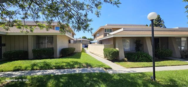
864 Picador Blvd
San Diego, CA 92154
2 Weeks Ago
Favorites
864 Picador Blvd

Favorites
Check Back Soon for Upcoming Availability
| Beds | Baths | Average SF |
|---|---|---|
| 2 Bedrooms 2 Bedrooms 2 Br | 2 Baths 2 Baths 2 Ba | 966 SF |
Fees and Policies
The fees below are based on community-supplied data and may exclude additional fees and utilities.
Pet policies are negotiable.
- Dogs Allowed
-
Fees not specified
-
Weight limit--
-
Pet Limit--
- Parking
-
Garage--
About This Property
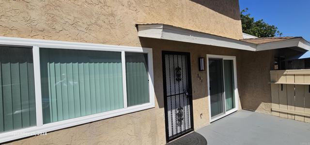
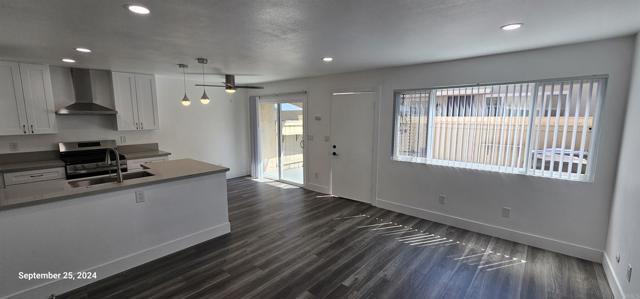
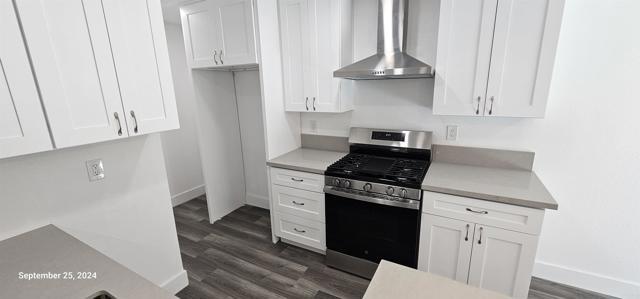
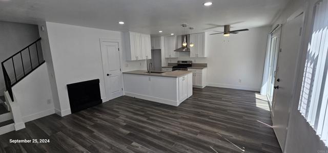
Newly remodeled with fresh paint, quartz counter tops, new appliances, new flooring and new windows. Come see this beautiful condo that is close to schools, shopping, dining and many more amenities. Includes 1 garage parking and 1 outdoor parking space. Complex offers a community pool. Must see!
864 Picador Blvd is a condo located in San Diego County and the 92154 ZIP Code.
Condo Features
- Washer/Dryer Hookup
- Fireplace
Location
Get Directions
Modern apartment complexes with plenty of amenities draw renters to the Otay Mesa West neighborhood of San Diego, which also features numerous single-family homes. Otay Mesa West sits near the south edge of San Diego Bay, and downtown San Diego is 10 miles to the north. Closer to the neighborhood rests the Mexican border crossing and Las Americas Premium Outlets, a huge outlet mall with dozens of nationally recognizable stores.
Get away from the city while you stay in your own neighborhood when you head to the Otay Valley Regional Park. Hiking, bicycling, and horse trails meander through the 200-acre park, and the views from the overlooks stretch all the way to the Coronado Bay Bridge and out to the Pacific Ocean. After your hike, join your neighbors at one of the food trucks typically found lining the park.
Learn more about living in Otay Mesa WestBelow are rent ranges for similar nearby apartments
Amenities
- Washer/Dryer Hookup
- Fireplace
Education
| Colleges & Universities | Distance | ||
|---|---|---|---|
| Colleges & Universities | Distance | ||
| Drive: | 17 min | 8.7 mi | |
| Drive: | 17 min | 12.8 mi | |
| Drive: | 18 min | 13.2 mi | |
| Drive: | 18 min | 14.0 mi |
864 Picador Blvd is within 17 minutes or 8.7 miles from Southwestern Coll, Chula Vista. It is also near San Diego City College and Thomas Jefferson School of Law.
Transportation options available in San Diego include Iris Avenue, located 1.6 miles from 864 Picador Blvd. 864 Picador Blvd is near San Diego International, located 16.5 miles or 23 minutes away.
| Transit / Subway | Distance | ||
|---|---|---|---|
| Transit / Subway | Distance | ||
|
|
Drive: | 4 min | 1.6 mi |
|
|
Drive: | 4 min | 1.9 mi |
|
|
Drive: | 4 min | 1.9 mi |
|
|
Drive: | 7 min | 2.9 mi |
|
|
Drive: | 7 min | 3.5 mi |
| Commuter Rail | Distance | ||
|---|---|---|---|
| Commuter Rail | Distance | ||
|
|
Drive: | 20 min | 13.9 mi |
|
|
Drive: | 22 min | 17.1 mi |
|
|
Drive: | 36 min | 28.7 mi |
|
|
Drive: | 44 min | 35.8 mi |
| Airports | Distance | ||
|---|---|---|---|
| Airports | Distance | ||
|
San Diego International
|
Drive: | 23 min | 16.5 mi |
Time and distance from 864 Picador Blvd.
| Shopping Centers | Distance | ||
|---|---|---|---|
| Shopping Centers | Distance | ||
| Walk: | 10 min | 0.6 mi | |
| Walk: | 10 min | 0.6 mi | |
| Walk: | 12 min | 0.7 mi |
864 Picador Blvd has 3 shopping centers within 0.7 mile, which is about a 12-minute walk. The miles and minutes will be for the farthest away property.
| Parks and Recreation | Distance | ||
|---|---|---|---|
| Parks and Recreation | Distance | ||
|
Otay Valley Regional Park
|
Drive: | 3 min | 1.4 mi |
|
Tijuana River National Estuarine Research Reserve
|
Drive: | 10 min | 4.4 mi |
|
Tijuana Slough National Wildlife Refuge
|
Drive: | 10 min | 4.4 mi |
|
Tijuana River Valley Regional Park
|
Drive: | 10 min | 4.7 mi |
|
Border Field State Park
|
Drive: | 16 min | 6.2 mi |
864 Picador Blvd has 5 parks within 6.2 miles, including Otay Valley Regional Park, Tijuana River Valley Regional Park, and Tijuana River National Estuarine Research Reserve.
| Hospitals | Distance | ||
|---|---|---|---|
| Hospitals | Distance | ||
| Drive: | 9 min | 5.0 mi | |
| Drive: | 15 min | 10.2 mi |
864 Picador Blvd is 5.0 miles from Sharp Chula Vista Medical Center, and is convenient to other hospitals, including Paradise Valley Hospital.
| Military Bases | Distance | ||
|---|---|---|---|
| Military Bases | Distance | ||
| Drive: | 12 min | 8.5 mi | |
| Drive: | 18 min | 11.9 mi |
864 Picador Blvd is 8.5 miles from San Diego Naval Air Station, and is convenient to other military bases, including US Naval Amphibious Base.
You May Also Like
Similar Rentals Nearby
-
-

-

-

-

-
 $3,0002 Beds, 1.5 Baths, 825 sq ftApartment for Rent
 -

-

-
 $2,5002 Beds, 1 Bath, 700 sq ftApartment for Rent
 -

What Are Walk Score®, Transit Score®, and Bike Score® Ratings?
Walk Score® measures the walkability of any address. Transit Score® measures access to public transit. Bike Score® measures the bikeability of any address.
What is a Sound Score Rating?
A Sound Score Rating aggregates noise caused by vehicle traffic, airplane traffic and local sources
864 Picador Blvd
San Diego, CA 92154