
$3,950
Total Monthly Price
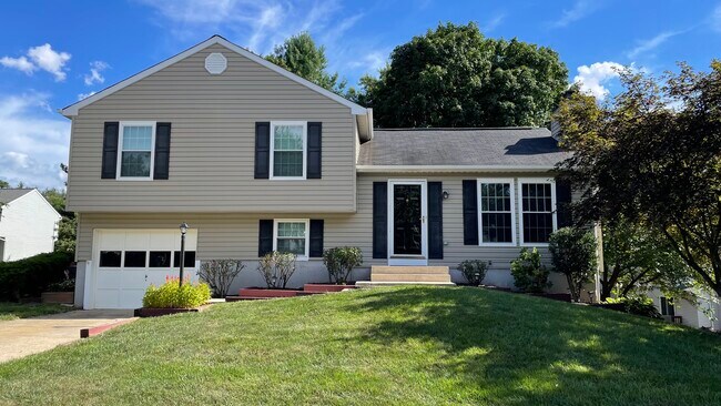
8559 Wheatfield Way
Ellicott City, MD 21043
Favorites
667-261-8446
-
Bedrooms
4
-
Bathrooms
2.5
-
Square Feet
2,100 sq ft
-
Available
Available Jul 1
Highlights
- Pets Allowed
- Hardwood Floors
- Smoke Free
- Deck
8559 Wheatfield Way

Favorites
About This Home
12 Month Lease,
$3,950 deposit,
Available Jul 1
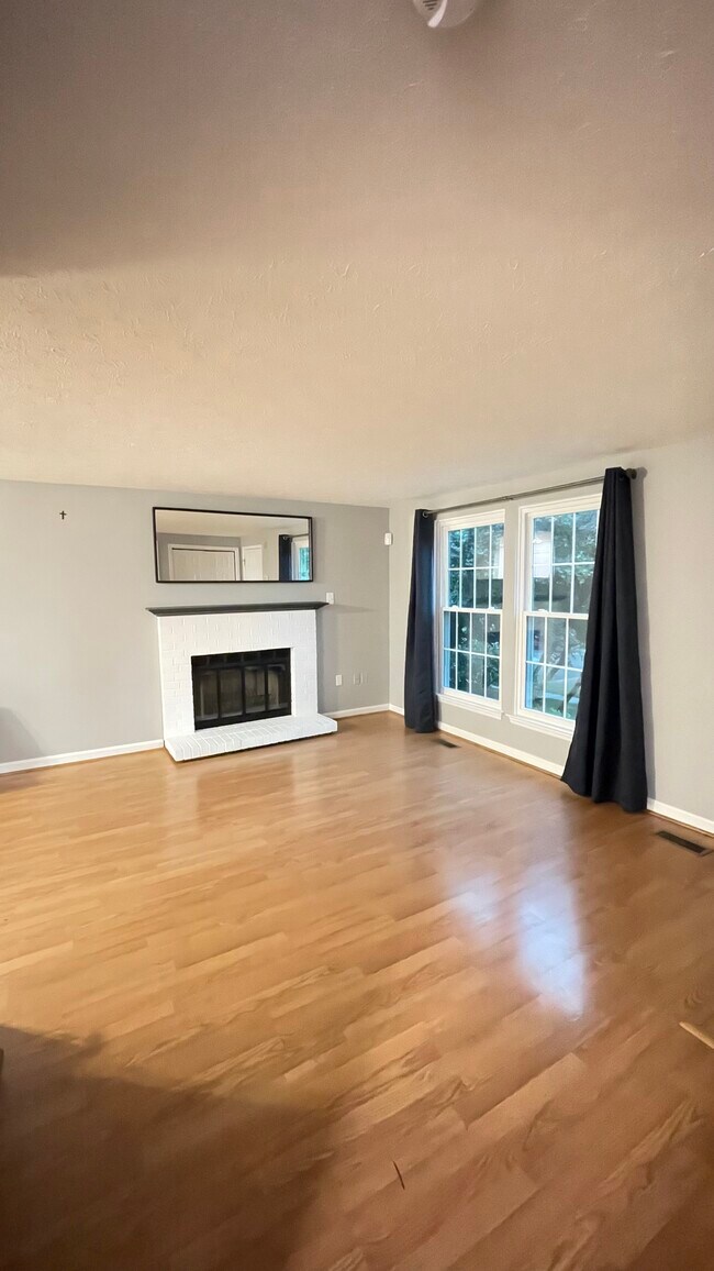
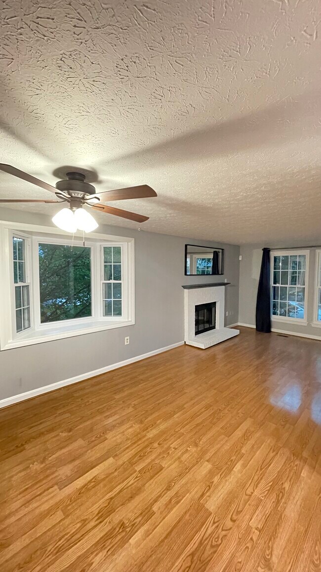
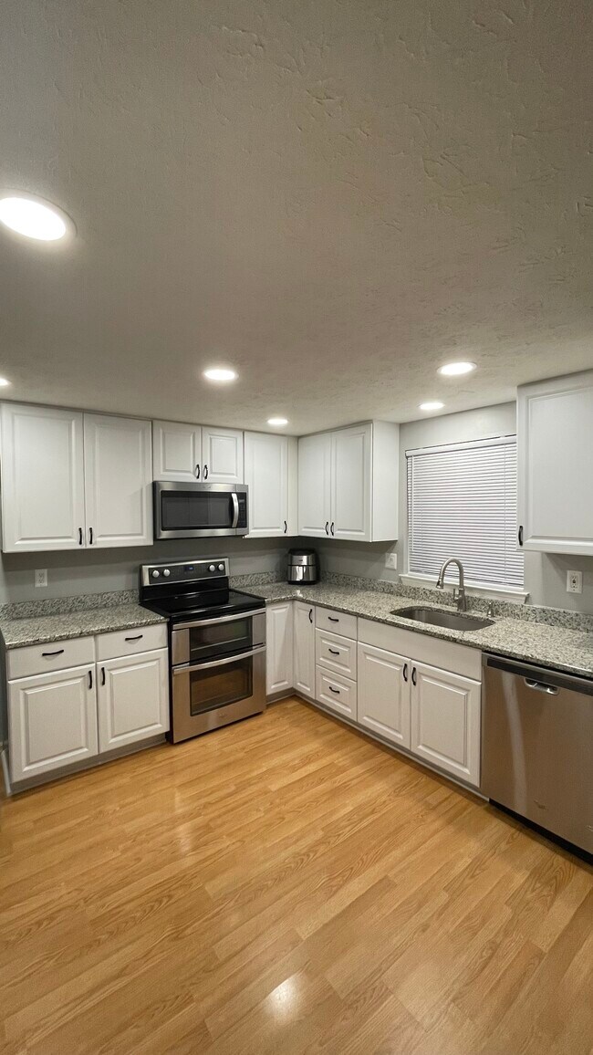
Enjoy the luxury and safety of this Recently Renovated 4 bedroom, 2.5 Bath, 1 Car Garage W/ 1 Car Driveway Smart Home located in the highly sought after community, Wheatfield, located in Ellicott City, MD. Centennial High School District! Completely Renovated with Smart Home Features! These rooms have tons of wall storage, closet space, and carpeted floors. Common areas such as the Foyer, Kitchen, Living room, and Family room have Hardwood floors. Located in Ellicott City. Less than a 5 min walk from Long Gate Shopping Center and the YMCA. RT 29/100 is less than a minute away; perfect for quick access to wherever you need to go! There is plenty of storage, a full beautiful kitchen (Granite counters) with brand new full size Stainless-steel appliances. No smoking, no drugs. Security deposit is one (1) month’s rent. Must be willing to agree to a background and credit check ($30) and provide pay stubs etc. It’s not a problem at all if you need a Co-signer on your lease. This home has lots of luxury features, common area space a 1 Car Garage with a 1 Car Pad, and a massive extended deck with oversized sunroom for relaxing or BBQs. Enjoy comfortable living in one of Howard County's most sought after neighborhood! If there’s ever a problem with anything maintenance related or otherwise, it will be taken care of immediately. Your comfort, satisfaction, and safety are a priority. (4 BR, 2 full 1 half BA, 1 Car Garage with 1 Car Driveway) For your convenience: (1) lease is for 12 Months. (2) Utilities are to be paid by the tenant. (3) Pets are allowed on a case by case basis for an additional fee. Please message me with any questions. Thanks for taking the time to thoroughly read my description!
8559 Wheatfield Way is a house located in Howard County and the 21043 ZIP Code.
* Price shown is total price based on community-supplied monthly required fees. Excludes user-selected optional fees and variable or usage-based fees and required charges due at or prior to move-in or at move-out. Price, availability, fees, and any applicable rent special are subject to change without notice.
* Square footage definitions vary. Displayed square footage is approximate.
House Features
Washer/Dryer
Hardwood Floors
Granite Countertops
Stainless Steel Appliances
- Washer/Dryer
- Smoke Free
- Granite Countertops
- Stainless Steel Appliances
- Kitchen
- Hardwood Floors
- Family Room
- Sunroom
- Deck
Fees and Policies
The fees listed below are community-provided and may exclude utilities or add-ons. All payments are made directly to the property and are non-refundable unless otherwise specified.
- Dogs Allowed
-
Fees not specified
- Cats Allowed
-
Fees not specified
Contact
- Phone Number
- Contact
Location
Get Directions
Ellicott City is the county seat of Howard County, Maryland, and holds a distinction few communities can claim — its historic downtown sits around the oldest surviving railroad station in the United States, built in 1830 as the first terminus of the original B&O Railroad line. Positioned between Baltimore and Washington, D.C., the community blends preserved 18th- and 19th-century architecture with newer residential development that fans out across 31 square miles of rolling Maryland terrain. Fort Meade and BWI Airport are within easy reach, giving the area a steady economic foundation alongside Howard County's well-regarded school system.
Neighborhoods here shift noticeably depending on where you land. The Route 40 corridor offers a lively stretch of international markets and eateries, while the Long Gate area provides a more suburban feel with convenient access to retail and major commuter routes.
Learn more about living in Ellicott City
Education
| Colleges & Universities | Distance | ||
|---|---|---|---|
| Colleges & Universities | Distance | ||
| Drive: | 12 min | 7.2 mi | |
| Drive: | 18 min | 7.4 mi | |
| Drive: | 18 min | 10.7 mi | |
| Drive: | 27 min | 14.5 mi |
8559 Wheatfield Way is within 18 minutes or 7.4 miles from CCBC Cantonsville. It is also near Howard Community College and UMBC.
Transportation options available in Ellicott City include Dorsey, located 7.0 miles from 8559 Wheatfield Way. 8559 Wheatfield Way is near Baltimore/Washington International Thurgood Marshall, located 13.4 miles or 21 minutes away, and Ronald Reagan Washington Ntl, located 34.6 miles or 55 minutes away.
| Transit / Subway | Distance | ||
|---|---|---|---|
| Transit / Subway | Distance | ||
|
|
Drive: | 12 min | 7.0 mi |
|
|
Drive: | 21 min | 13.5 mi |
|
|
Drive: | 22 min | 13.7 mi |
|
|
Drive: | 23 min | 14.4 mi |
|
|
Drive: | 22 min | 14.7 mi |
| Commuter Rail | Distance | ||
|---|---|---|---|
| Commuter Rail | Distance | ||
| Drive: | 12 min | 7.0 mi | |
| Drive: | 12 min | 7.0 mi | |
| Drive: | 17 min | 8.0 mi | |
| Drive: | 18 min | 9.2 mi | |
| Drive: | 18 min | 9.2 mi |
| Airports | Distance | ||
|---|---|---|---|
| Airports | Distance | ||
|
Baltimore/Washington International Thurgood Marshall
|
Drive: | 21 min | 13.4 mi |
|
Ronald Reagan Washington Ntl
|
Drive: | 55 min | 34.6 mi |
Getting Around
 What do Walkability, Transit, Drivability, and Bikeability mean?
Walkability measures the walking distance to day-to-day needs.
Transit measures access to public transportation.
Drivability measures congestion, parking availability, and access to major roads.
Bikeability measures the suitability for cycling.
How It Works
What do Walkability, Transit, Drivability, and Bikeability mean?
Walkability measures the walking distance to day-to-day needs.
Transit measures access to public transportation.
Drivability measures congestion, parking availability, and access to major roads.
Bikeability measures the suitability for cycling.
How It Works
Fairly Walkable
Walkability
40
/ 100
Minimal Public Transit
Transit
10
/ 100
Exceptionally Drivable
Drivability
100
/ 100
Fairly Bikeable
Bikeability
40
/ 100
Scores provided by
Active
Soundscore™
76
/ 100
Traffic
ActiveAirport
CalmBusinesses
CalmScores provided by
HowLoud What is a Sound Score Rating? A Sound Score Rating aggregates noise caused by vehicle traffic, airplane traffic and local sources. How It WorksTime and distance from 8559 Wheatfield Way.
| Shopping Centers | Distance | ||
|---|---|---|---|
| Shopping Centers | Distance | ||
| Walk: | 14 min | 0.7 mi | |
| Walk: | 16 min | 0.9 mi | |
| Walk: | 19 min | 1.0 mi |
8559 Wheatfield Way has 3 shopping centers within 1.0 mile, which is about a 19-minute walk. The miles and minutes will be for the farthest away property.
| Parks and Recreation | Distance | ||
|---|---|---|---|
| Parks and Recreation | Distance | ||
|
Benjamin Banneker Historical Park and Museum
|
Drive: | 11 min | 4.3 mi |
|
Clark's Elioak Farm
|
Drive: | 8 min | 4.9 mi |
|
Banneker Planetarium
|
Drive: | 18 min | 7.4 mi |
|
Mt Pleasant - Howard County Conservancy
|
Drive: | 14 min | 8.0 mi |
|
Gwynns Falls - Leakin Park
|
Drive: | 19 min | 12.0 mi |
8559 Wheatfield Way has 5 parks within 12.0 miles, including Benjamin Banneker Historical Park and Museum, Clark's Elioak Farm, and Banneker Planetarium.
| Hospitals | Distance | ||
|---|---|---|---|
| Hospitals | Distance | ||
| Drive: | 12 min | 6.4 mi | |
| Drive: | 17 min | 7.1 mi | |
| Drive: | 18 min | 11.6 mi |
8559 Wheatfield Way has 3 hospitals within 11.6 miles, the nearest is Howard County General Hospital which is 6.4 miles away and a 12 minute drive.
| Military Bases | Distance | ||
|---|---|---|---|
| Military Bases | Distance | ||
| Drive: | 25 min | 13.8 mi | |
| Drive: | 41 min | 27.8 mi | |
| Drive: | 49 min | 31.3 mi |
8559 Wheatfield Way has 3 military bases within 31.3 miles, the nearest is Fort George Meade which is 13.8 miles away and a 25 minute drive.
Amenities
- Washer/Dryer
- Smoke Free
- Granite Countertops
- Stainless Steel Appliances
- Kitchen
- Hardwood Floors
- Family Room
- Sunroom
- Deck
8559 Wheatfield Way Photos
What Are Walk Score®, Transit Score®, and Bike Score® Ratings?
Walk Score® measures the walkability of any address. Transit Score® measures access to public transit. Bike Score® measures the bikeability of any address.
What is a Sound Score Rating?
A Sound Score Rating aggregates noise caused by vehicle traffic, airplane traffic and local sources.

8559 Wheatfield Way
Ellicott City, MD 21043