$2,000
/ Month
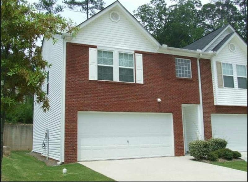
847 Brickleridge Ln SE
Mableton, GA 30126
Favorites
847 Brickleridge Ln SE

Favorites
Check Back Soon for Upcoming Availability
| Beds | Baths | Average SF |
|---|---|---|
| 3 Bedrooms 3 Bedrooms 3 Br | 2.5 Baths 2.5 Baths 2.5 Ba | 1,512 SF |
About This Property
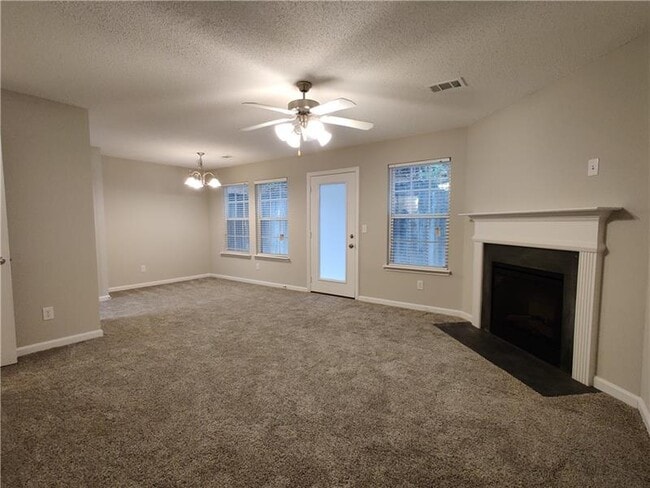
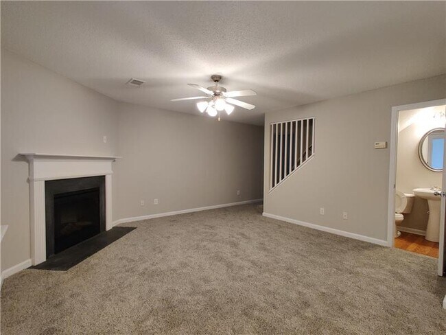
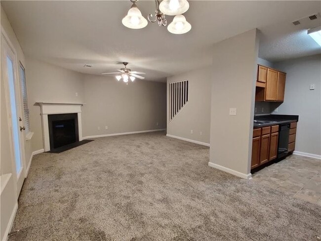
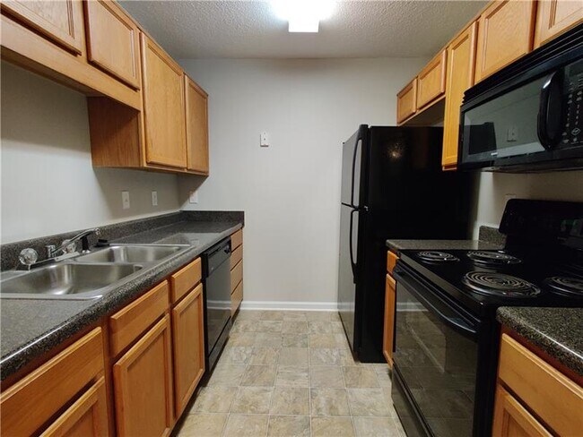
MUST-SEE END UNIT! 3 bedroom/ 2.5 bath with an additional bonus/loft upstairs perfect for home office. Spacious open concept family room. Laundry upstairs off primary bedroom. Great updated rental property with newer carpet and paint! Level driveway with 2-car garage. Private backyard patio. Easy access to I-285 & I-20. Walking distance to groceries, banking and restaurants. Landlord highly prefers a minimum 24 month lease. NO Pets. Non-smoking only. Minimum credit score of 670 is required.
847 Brickleridge Ln Se is a townhome located in Cobb County and the 30126 ZIP Code. This area is served by the Cobb County School District attendance zone.
847 Brickleridge Ln SE,
Mableton,
GA
30126
Mableton became Georgia's newest official city in 2023, making it one of the most talked-about addresses in the greater Atlanta area. Sitting in Cobb County along the southwestern edge of the metro, the city carries a settled, community-oriented feel while staying well-connected to downtown Atlanta via Interstate 285 and Interstate 20. The Silver Comet Trail, a paved multi-use path stretching through the heart of the city, gives residents an accessible outlet for outdoor activity without leaving the neighborhood. The Mable House arts complex anchors the city's cultural identity, offering concerts, theater, and a direct link to Mableton's 19th-century roots as a cotton farming community.
The housing stock here covers a wide range, from established single-family homes and townhomes to newer apartment communities that have followed the city's recent incorporation.
Learn more about living in Mableton
Education
| Colleges & Universities | Distance | ||
|---|---|---|---|
| Colleges & Universities | Distance | ||
| Drive: | 10 min | 5.2 mi | |
| Drive: | 19 min | 9.6 mi | |
| Drive: | 16 min | 9.9 mi | |
| Drive: | 17 min | 10.3 mi |
847 Brickleridge Ln SE is within 10 minutes or 5.2 miles from Chatt. Tech, Austell. It is also near Clark Atlanta University and Morehouse College.
Schools


Public Elementary School
Grades PK-5
1,099 Students
Attendance Zone
Public Middle School
Grades 6-8
802 Students
Attendance Zone
Public High School
Grades 9-12
2,368 Students
Attendance Zone
Private Elementary, Middle & High School
Grades PK-12
852 Students
Nearby
Private Elementary & Middle School
Grades PK-8
Nearby
Private Elementary & Middle School
Grades K-8
Nearby
School data provided by
 The GreatSchools Rating helps parents compare schools within a state based on a variety of school quality indicators and provides a helpful picture of how effectively each school serves all of its students. Ratings are on a scale of 1 (below average) to 10 (above average) and can include test scores, college readiness, academic progress, advanced courses, equity, discipline and attendance data. We also advise parents to visit schools, consider other information on school performance and programs, and consider family needs as part of the school selection process.
View GreatSchools Rating Methodology
Data provided by GreatSchools.org © 2026. All rights reserved.
View GreatSchools Rating Methodology
Data provided by GreatSchools.org © 2026. All rights reserved.
Transportation options available in Mableton include Hamilton E Holmes, located 6.6 miles from 847 Brickleridge Ln SE. 847 Brickleridge Ln SE is near Hartsfield - Jackson Atlanta International, located 19.3 miles or 30 minutes away.
| Transit / Subway | Distance | ||
|---|---|---|---|
| Transit / Subway | Distance | ||
|
|
Drive: | 12 min | 6.6 mi |
|
|
Drive: | 12 min | 6.9 mi |
|
|
Drive: | 13 min | 7.7 mi |
|
|
Drive: | 15 min | 8.8 mi |
|
|
Drive: | 17 min | 9.5 mi |
| Commuter Rail | Distance | ||
|---|---|---|---|
| Commuter Rail | Distance | ||
|
|
Drive: | 21 min | 11.9 mi |
| Airports | Distance | ||
|---|---|---|---|
| Airports | Distance | ||
|
Hartsfield - Jackson Atlanta International
|
Drive: | 30 min | 19.3 mi |
Walkability Near 847 Brickleridge Ln SE Mableton, GA 30126
Getting Around
 What do Walkability, Transit, Drivability, and Bikeability mean?
Walkability measures the walking distance to day-to-day needs.
Transit measures access to public transportation.
Drivability measures congestion, parking availability, and access to major roads.
Bikeability measures the suitability for cycling.
How It Works
What do Walkability, Transit, Drivability, and Bikeability mean?
Walkability measures the walking distance to day-to-day needs.
Transit measures access to public transportation.
Drivability measures congestion, parking availability, and access to major roads.
Bikeability measures the suitability for cycling.
How It Works
Fairly Walkable
Walkability
40
/ 100
Minimal Public Transit
Transit
0
/ 100
Exceptionally Drivable
Drivability
90
/ 100
Somewhat Bikeable
Bikeability
30
/ 100
Scores provided by
-
Soundscore™
-
/ 100
Traffic
-Airport
-Businesses
-Scores provided by
HowLoud What is a Sound Score Rating? A Sound Score Rating aggregates noise caused by vehicle traffic, airplane traffic and local sources. How It WorksTime and distance from 847 Brickleridge Ln SE.
| Shopping Centers | Distance | ||
|---|---|---|---|
| Shopping Centers | Distance | ||
| Walk: | 11 min | 0.6 mi | |
| Walk: | 16 min | 0.8 mi | |
| Drive: | 5 min | 2.7 mi |
847 Brickleridge Ln SE has 3 shopping centers within 2.7 miles, which is about a 5-minute drive. The miles and minutes will be for the farthest away property.
| Parks and Recreation | Distance | ||
|---|---|---|---|
| Parks and Recreation | Distance | ||
|
Silver Comet Trail
|
Drive: | 13 min | 6.3 mi |
|
Cascade Springs Nature Preserve
|
Drive: | 14 min | 8.7 mi |
|
West Atlanta Watershed Alliance (WAWA)
|
Drive: | 17 min | 9.4 mi |
|
Atlanta BeltLine Southwest Connector Spur Trail
|
Drive: | 19 min | 10.6 mi |
|
Sweetwater Creek State Park
|
Drive: | 20 min | 11.0 mi |
847 Brickleridge Ln SE has 5 parks within 11.0 miles, including Silver Comet Trail, Atlanta BeltLine Southwest Connector Spur Trail, and Cascade Springs Nature Preserve.
| Hospitals | Distance | ||
|---|---|---|---|
| Hospitals | Distance | ||
| Drive: | 11 min | 5.9 mi | |
| Drive: | 15 min | 7.4 mi | |
| Drive: | 16 min | 9.7 mi |
847 Brickleridge Ln SE has 3 hospitals within 9.7 miles, the nearest is Ridgeview Institute which is 5.9 miles away and a 11 minute drive.
| Military Bases | Distance | ||
|---|---|---|---|
| Military Bases | Distance | ||
| Drive: | 24 min | 11.4 mi | |
| Drive: | 21 min | 12.2 mi | |
| Drive: | 39 min | 22.6 mi |
847 Brickleridge Ln SE has 3 military bases within 22.6 miles, the nearest is Dobbins Air Force Base which is 11.4 miles away and a 24 minute drive.
You May Also Like
Similar Rentals Nearby
-
-
3 Beds$2,485+Total Monthly PriceTotal Monthly Price NewPrices include base rent and required monthly fees of $125. Variable costs based on usage may apply.Base Rent:3 Beds$2,359+2 Months Free
Pets Allowed Pool In Unit Washer & Dryer Clubhouse Stainless Steel Appliances Granite Countertops Gated
-
3 Beds$2,241+Total Monthly PriceTotal Monthly Price NewPrices include required monthly fees of $143.Base Rent:3 Beds$2,097+Specials
Pets Allowed Fitness Center Pool Kitchen Walk-In Closets Clubhouse
-
-
-
-
3 Beds$2,244+Total Monthly PriceTotal Monthly Price NewPrices include all required monthly fees.
Pets Allowed Fitness Center Pool Dishwasher Refrigerator Kitchen
-
3 Beds$3,138+Total Monthly PriceTotal Monthly Price NewPrices include base rent and required monthly fees of $174. Variable costs based on usage may apply.Base Rent:3 Beds$2,963+Specials
Pets Allowed Fitness Center Pool Dishwasher In Unit Washer & Dryer Walk-In Closets Stainless Steel Appliances
-
-


What Are Walk Score®, Transit Score®, and Bike Score® Ratings?
Walk Score® measures the walkability of any address. Transit Score® measures access to public transit. Bike Score® measures the bikeability of any address.
What is a Sound Score Rating?
A Sound Score Rating aggregates noise caused by vehicle traffic, airplane traffic and local sources.

847 Brickleridge Ln SE
Mableton, GA 30126