
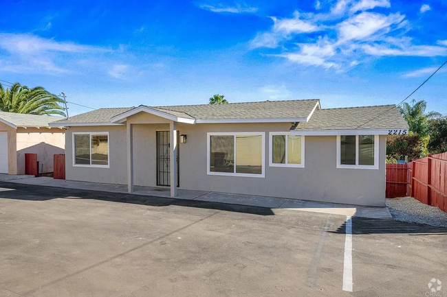
$4,250 / Month
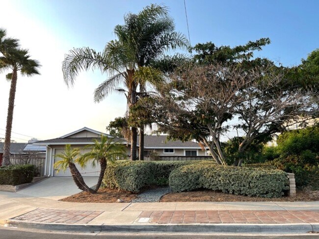
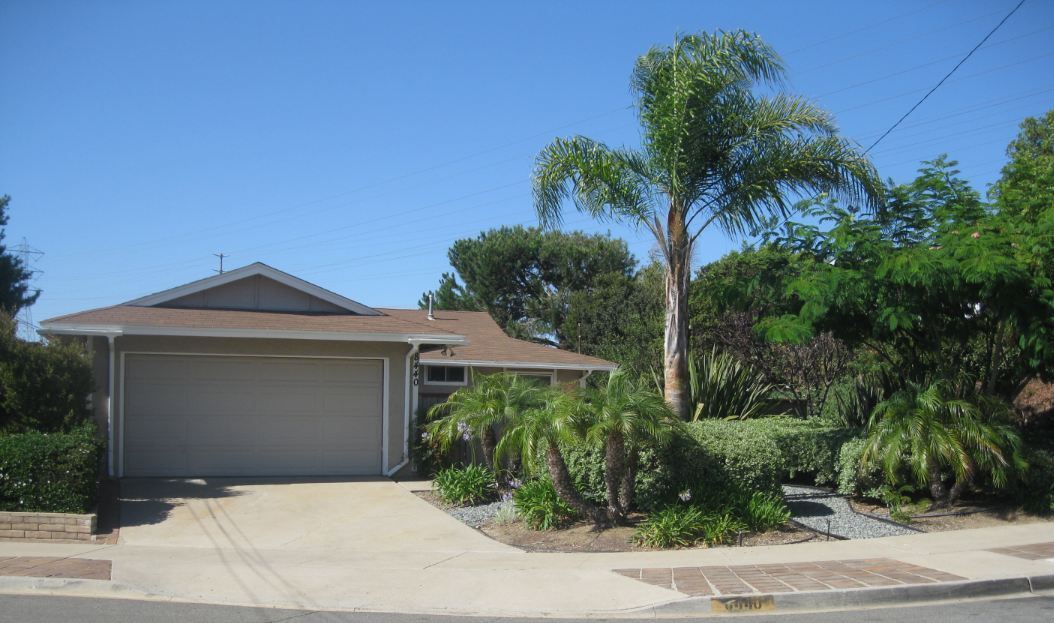
8440 Fireside Ave
San Diego, CA 92123
2 Weeks Ago
Favorites
8440 Fireside Ave

Favorites
Check Back Soon for Upcoming Availability
| Beds | Baths | Average SF |
|---|---|---|
| 3 Bedrooms 3 Bedrooms 3 Br | 2 Baths 2 Baths 2 Ba | 1,200 SF |
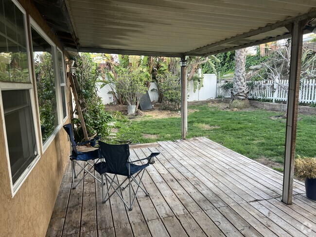
About This Property
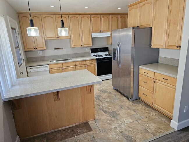
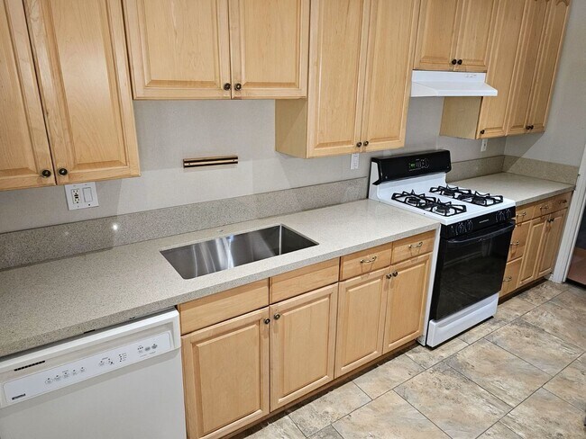
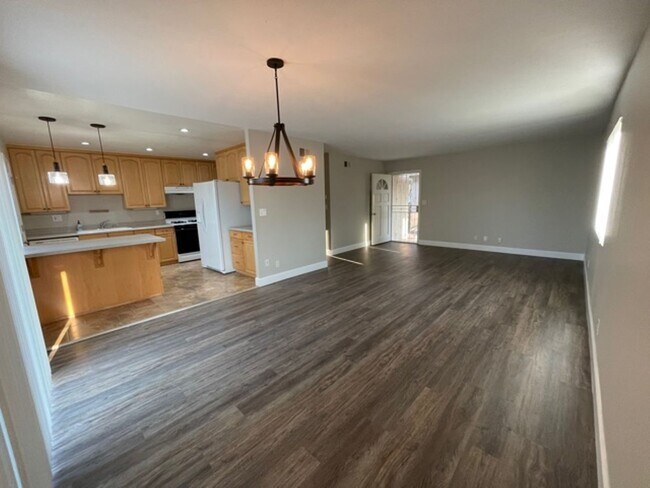
This centrally located 1,200 SF 3BR-2BA home with canyon views is located on a quiet cul-de-sac. It has a professionally landscaped front yard, large fenced front patio, side yard, backyard with productive fruit trees, and rent includes biweekly yard service! All new quartz counter tops, vinyl flooring, paint, and upgraded bathrooms. Appliances include dishwasher, stove, oven, new fridge, as well as whole house fan. Laundry room located in house. Dogs accepted on approval with additional deposit. Easy access to Mission Valley, Kearny Mesa, 8/163/805 freeways. Please contact Scott at
8440 Fireside Ave is a house located in San Diego County and the 92123 ZIP Code. This area is served by the San Diego Unified attendance zone.
Location
Get Directions
Located between Interstate 805 and Interstate 15, and just 10 miles from Downtown San Diego, Serra Mesa places residents close to the city's major attractions, while enjoying a more relaxed life living in the heart of the city. For entertainment, Serra Mesa is convenient to Sea World, Balboa Park (home of the iconic San Diego Zoo), and Mission Bay. The neighborhood neighbors Mission Valley, a commercial hub with several malls and restaurants. SDDCU Stadium rests just south of the neighborhood. Serra Mesa is also near three medical facilities which are one of the area’s largest employers. Along with several neighborhood parks, Serra Mesa is surrounded by natural areas including Tecolote Canyon Natural Park and Nature Center and Mission Trails Regional Park, a 7,000-plus acre park with miles of trails and a lake. Similar to other San Diego neighborhoods, rentals here are expensive, but there are many options that are significantly cheaper compared to other neighborhoods.
Learn more about living in Serra MesaBelow are rent ranges for similar nearby apartments
Education
| Colleges & Universities | Distance | ||
|---|---|---|---|
| Colleges & Universities | Distance | ||
| Drive: | 5 min | 1.8 mi | |
| Drive: | 7 min | 3.3 mi | |
| Drive: | 8 min | 3.5 mi | |
| Drive: | 12 min | 4.9 mi |
8440 Fireside Ave is within 5 minutes or 1.8 miles from The Art Inst., San Diego. It is also near San Diego Continuing Education and San Diego Mesa College.
Schools


Public Elementary & Middle School
Grades K-8
591 Students
Nearby
Public Elementary School
Grades K-5
289 Students
Attendance Zone
Public Middle School
Grades 6-8
384 Students
Attendance Zone
Public High School
Grades 9-12
344 Students
Attendance Zone
Public High School
Grades 9-12
311 Students
Attendance Zone
Private Elementary & Middle School
Grades PK-8
225 Students
Nearby
Private Elementary & Middle School
Grades PK-8
282 Students
Nearby
Private Middle & High School
Grades 8-12
11 Students
Nearby
School data provided by
 The GreatSchools Rating helps parents compare schools within a state based on a variety of school quality indicators and provides a helpful picture of how effectively each school serves all of its students. Ratings are on a scale of 1 (below average) to 10 (above average) and can include test scores, college readiness, academic progress, advanced courses, equity, discipline and attendance data. We also advise parents to visit schools, consider other information on school performance and programs, and consider family needs as part of the school selection process.
View GreatSchools Rating Methodology
View GreatSchools Rating Methodology
Transportation options available in San Diego include Hazard Center, located 2.7 miles from 8440 Fireside Ave. 8440 Fireside Ave is near San Diego International, located 6.8 miles or 15 minutes away.
| Transit / Subway | Distance | ||
|---|---|---|---|
| Transit / Subway | Distance | ||
|
|
Drive: | 7 min | 2.7 mi |
|
|
Drive: | 7 min | 2.9 mi |
|
|
Drive: | 8 min | 3.0 mi |
|
|
Drive: | 8 min | 3.1 mi |
|
|
Drive: | 9 min | 3.9 mi |
| Commuter Rail | Distance | ||
|---|---|---|---|
| Commuter Rail | Distance | ||
|
|
Drive: | 13 min | 6.8 mi |
|
|
Drive: | 14 min | 7.5 mi |
|
|
Drive: | 17 min | 11.3 mi |
|
|
Drive: | 25 min | 18.3 mi |
|
|
Drive: | 29 min | 22.0 mi |
| Airports | Distance | ||
|---|---|---|---|
| Airports | Distance | ||
|
San Diego International
|
Drive: | 15 min | 6.8 mi |
Time and distance from 8440 Fireside Ave.
| Shopping Centers | Distance | ||
|---|---|---|---|
| Shopping Centers | Distance | ||
| Walk: | 14 min | 0.7 mi | |
| Drive: | 4 min | 1.4 mi | |
| Drive: | 6 min | 2.8 mi |
8440 Fireside Ave has 3 shopping centers within 2.8 miles, which is about a 6-minute walk. The miles and minutes will be for the farthest away property.
| Parks and Recreation | Distance | ||
|---|---|---|---|
| Parks and Recreation | Distance | ||
|
San Diego Zoo
|
Drive: | 12 min | 6.0 mi |
|
San Diego Natural History Museum
|
Drive: | 13 min | 6.4 mi |
|
Old Town San Diego Historic District
|
Drive: | 11 min | 6.4 mi |
|
Fleet Science Center
|
Drive: | 15 min | 6.6 mi |
|
Tecolote Canyon Natural Park & Nature Center
|
Drive: | 13 min | 7.6 mi |
8440 Fireside Ave has 5 parks within 7.6 miles, including Tecolote Canyon Natural Park & Nature Center, Old Town San Diego Historic District, and San Diego Natural History Museum.
| Hospitals | Distance | ||
|---|---|---|---|
| Hospitals | Distance | ||
| Drive: | 6 min | 2.7 mi | |
| Drive: | 6 min | 2.8 mi | |
| Drive: | 7 min | 3.2 mi |
8440 Fireside Ave has 3 hospitals within 3.2 miles, the nearest is Sharp Memorial Hospital which is 2.7 miles away and a 6 minute drive.
You May Also Like
Similar Rentals Nearby
What Are Walk Score®, Transit Score®, and Bike Score® Ratings?
Walk Score® measures the walkability of any address. Transit Score® measures access to public transit. Bike Score® measures the bikeability of any address.
What is a Sound Score Rating?
A Sound Score Rating aggregates noise caused by vehicle traffic, airplane traffic and local sources
8440 Fireside Ave
San Diego, CA 92123