
$7,495 / Month
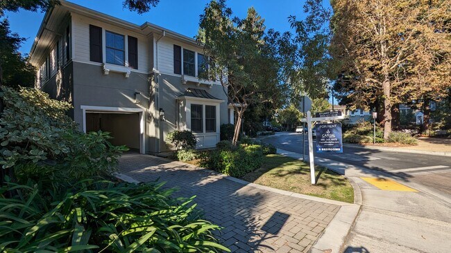
843 Paulson Cir
Menlo Park, CA 94025
2 Weeks Ago
Favorites
843 Paulson Cir

Favorites
Check Back Soon for Upcoming Availability
| Beds | Baths | Average SF |
|---|---|---|
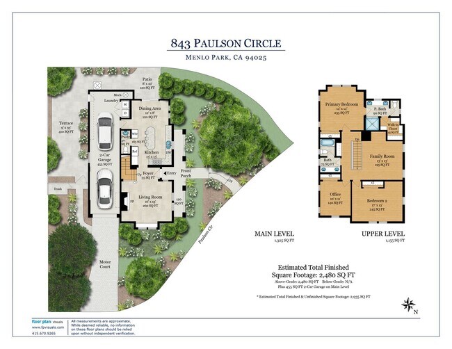
| 3 Bedrooms 3 Bedrooms 3 Br | 2.5 Baths 2.5 Baths 2.5 Ba | 1,758 SF |
Fees and Policies
The fees below are based on community-supplied data and may exclude additional fees and utilities.
About This Property
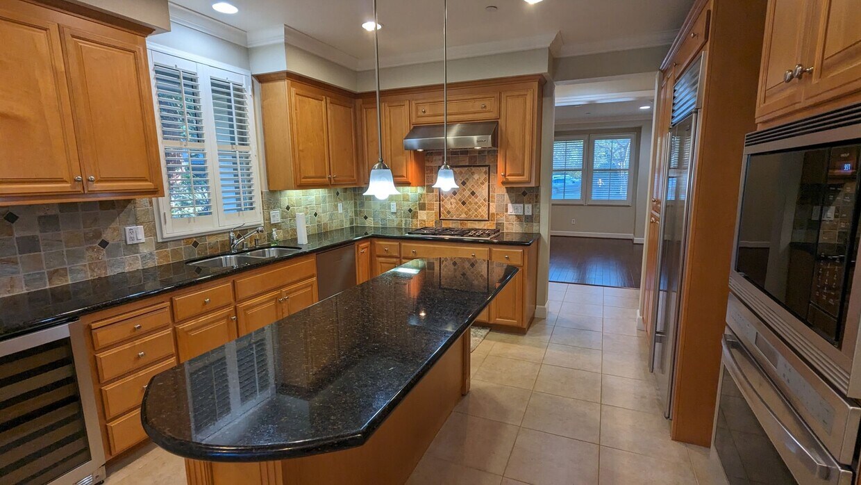
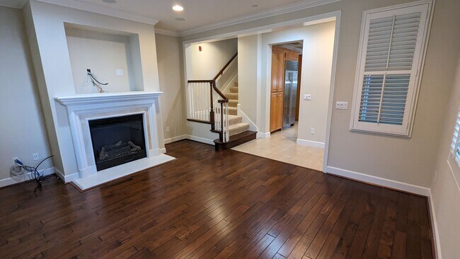
Happy New Year! 3 Bed 2.5 Bath (+ loft) single family home in Menlo Park Ready for new occupants. Granite countertops in kitchen, maple hardwood floors, high ceilings, spacious primary bedroom with marble bath and walk-in closet. Separate attached exterior 3' x 3' closet for storage. Shutters in all rooms. Central alarm system. A/C, Wi-FI, ethernet available in all rooms. Fire sprinkler system. New Washer/Dryer. Freshly painted. Excellent schools. Walk/Bike to Menlo-Atherton High School, Close to Burgess Park and Community Center, Swimming Pool, City Hall, Caltrain station, Facebook Offices, Google, Intuit, Menlo Park Business District and Palo Alto University Avenue Business District. Quick access to 101 Freeway. Please call/text Eleni Giotinis for showing at or email at: Apply on our website:
843 Paulson Cir is a house located in San Mateo County and the 94025 ZIP Code. This area is served by the Menlo Park City Elementary attendance zone.
House Features
Dishwasher
Microwave
Refrigerator
Range
- Dishwasher
- Microwave
- Range
- Refrigerator
Location
Get Directions
Linfield Oaks is a beautiful community full of charming homes, manicured lawns, and gorgeous tree cover. The neighborhood itself is almost entirely residential, but it offers direct access to a broad variety of amenities. Burgess Park offers everything from swimming to soccer facilities, and several other public parks can be reached by foot or bike in no time.
The Stanford Shopping Center and University Avenue are both practically right next door, giving Linfield Oaks residents near-endless selection of shopping, dining, and nightlife just minutes away. The Menlo Park division of the VA Palo Alto Health Care System is just up Willow Road, making it an excellent location for medical professionals.
Learn more about living in Linfield Oaks
Amenities
- Dishwasher
- Microwave
- Range
- Refrigerator
Education
| Colleges & Universities | Distance | ||
|---|---|---|---|
| Colleges & Universities | Distance | ||
| Drive: | 6 min | 2.1 mi | |
| Drive: | 10 min | 3.3 mi | |
| Drive: | 12 min | 6.5 mi | |
| Drive: | 19 min | 8.8 mi |
843 Paulson Cir is within 6 minutes or 2.1 miles from Menlo College. It is also near Stanford University and Foothill College, Middlefield.
Schools


Public Elementary School
Grades K-5
367 Students
Nearby
Public Elementary School
Grades K-5
602 Students
Attendance Zone
Public Middle School
Grades 6-8
867 Students
Attendance Zone
Public High School
Grades 9-12
2,125 Students
Attendance Zone
Private Elementary, Middle & High School
Grades PK-12
247 Students
Nearby
Private Middle & High School
Grades 7-12
Nearby
School data provided by
 The GreatSchools Rating helps parents compare schools within a state based on a variety of school quality indicators and provides a helpful picture of how effectively each school serves all of its students. Ratings are on a scale of 1 (below average) to 10 (above average) and can include test scores, college readiness, academic progress, advanced courses, equity, discipline and attendance data. We also advise parents to visit schools, consider other information on school performance and programs, and consider family needs as part of the school selection process.
View GreatSchools Rating Methodology
Data provided by GreatSchools.org © 2025. All rights reserved.
View GreatSchools Rating Methodology
Data provided by GreatSchools.org © 2025. All rights reserved.
Transportation options available in Menlo Park include Bayshore Nasa Station, located 8.8 miles from 843 Paulson Cir. 843 Paulson Cir is near Norman Y Mineta San Jose International, located 16.4 miles or 23 minutes away, and San Francisco International, located 19.4 miles or 27 minutes away.
| Transit / Subway | Distance | ||
|---|---|---|---|
| Transit / Subway | Distance | ||
| Drive: | 13 min | 8.8 mi | |
|
|
Drive: | 14 min | 8.9 mi |
| Drive: | 14 min | 9.2 mi | |
|
|
Drive: | 14 min | 9.2 mi |
|
|
Drive: | 15 min | 9.4 mi |
| Commuter Rail | Distance | ||
|---|---|---|---|
| Commuter Rail | Distance | ||
| Drive: | 3 min | 1.2 mi | |
| Drive: | 4 min | 1.3 mi | |
| Drive: | 8 min | 2.9 mi | |
| Drive: | 10 min | 3.6 mi | |
| Drive: | 12 min | 4.8 mi |
| Airports | Distance | ||
|---|---|---|---|
| Airports | Distance | ||
|
Norman Y Mineta San Jose International
|
Drive: | 23 min | 16.4 mi |
|
San Francisco International
|
Drive: | 27 min | 19.4 mi |
Time and distance from 843 Paulson Cir.
| Shopping Centers | Distance | ||
|---|---|---|---|
| Shopping Centers | Distance | ||
| Drive: | 4 min | 1.3 mi | |
| Drive: | 4 min | 1.4 mi | |
| Drive: | 6 min | 1.9 mi |
843 Paulson Cir has 3 shopping centers within 1.9 miles, which is about a 6-minute drive. The miles and minutes will be for the farthest away property.
| Parks and Recreation | Distance | ||
|---|---|---|---|
| Parks and Recreation | Distance | ||
|
Hopkins Creekside Park
|
Walk: | 4 min | 0.2 mi |
|
El Palo Alto Park
|
Walk: | 11 min | 0.6 mi |
|
Seminary Oaks Park
|
Walk: | 13 min | 0.7 mi |
|
Burgess Park
|
Walk: | 13 min | 0.7 mi |
|
Jack W. Lyle Park
|
Drive: | 5 min | 1.9 mi |
843 Paulson Cir has 5 parks within 1.9 miles, including Hopkins Creekside Park, El Palo Alto Park, and Seminary Oaks Park.
| Hospitals | Distance | ||
|---|---|---|---|
| Hospitals | Distance | ||
| Drive: | 7 min | 2.4 mi | |
| Drive: | 8 min | 3.0 mi | |
| Drive: | 10 min | 5.8 mi |
843 Paulson Cir has 3 hospitals within 5.8 miles, the nearest is Lucile Salter Packard Children's Hospital at Stanford which is 2.4 miles away and a 7 minute drive.
| Military Bases | Distance | ||
|---|---|---|---|
| Military Bases | Distance | ||
| Drive: | 16 min | 9.3 mi |
843 Paulson Cir is 9.3 miles and a 16 minute drive from Ames Research Center.
You May Also Like
Similar Rentals Nearby


What Are Walk Score®, Transit Score®, and Bike Score® Ratings?
Walk Score® measures the walkability of any address. Transit Score® measures access to public transit. Bike Score® measures the bikeability of any address.
What is a Sound Score Rating?
A Sound Score Rating aggregates noise caused by vehicle traffic, airplane traffic and local sources

843 Paulson Cir
Menlo Park, CA 94025