
$3,700
/ Month
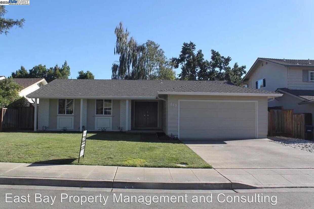
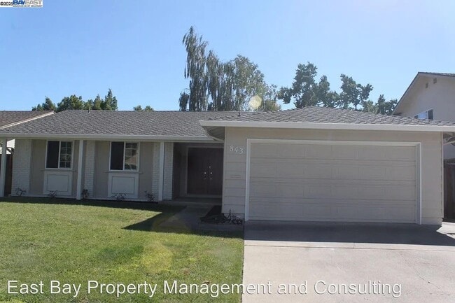
843 Avalon Way
Livermore, CA 94550
Today
|
Edit
Favorites
925-980-1900
-
Bedrooms
3
-
Bathrooms
2
-
Square Feet
1,651 sq ft
-
Available
Available Now
Highlights
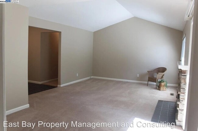
- Contemporary Architecture
- Vaulted Ceiling
- Solid Surface Countertops
- Breakfast Area or Nook
- Double Oven
- 2 Car Attached Garage
843 Avalon Way

Favorites
About This Home
Available Now
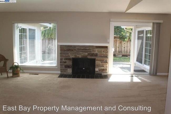
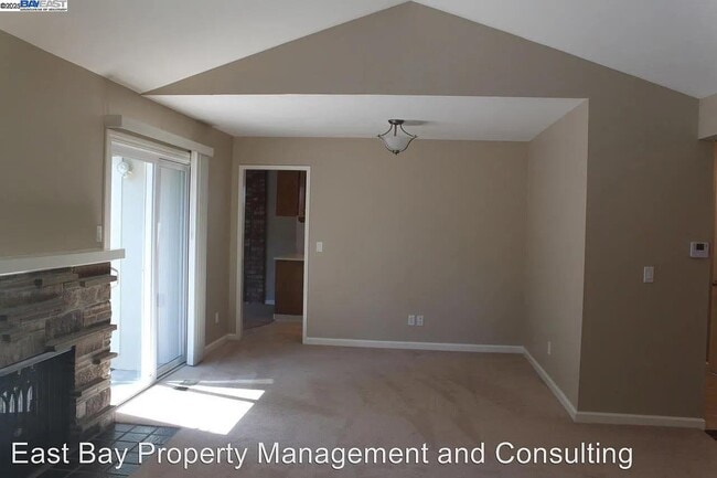
Sunset West beauty in great location. Single story with 1651 sq. ft. Will include Brand NEW CARPETING. dishwasher and cooktop. Open and Airy front room with Vaulted ceilings and formal dining room. Includes spacious family room. Kitchen with double ovens,recessed lighting,Refrigerator,large pantry and Kitchen nook. Enjoy 3 bedrooms and 2 full bathrooms. Master bedroom with 2 separate closets,ceiling fan and sliding door to beautiful backyard. Inside laundry with washer and dryer. Finished painted Garage with garage door opener. Includes Gardener.
843 Avalon Way is a house located in Alameda County and the 94550 ZIP Code. This area is served by the Livermore Valley Joint Unified attendance zone.
* Price shown is base rent. Excludes user-selected optional fees and variable or usage-based fees and required charges due at or prior to move-in or at move-out. Price, availability, fees, and any applicable rent special are subject to change without notice.
* Square footage definitions vary. Displayed square footage is approximate.
Home Details
Home Type
Single Family Detached Home
Year Built
Built in 1965
Bedrooms and Bathrooms
2 Full Bathrooms
3 Bedrooms
Flooring
Tile
Carpet
Vinyl
Home Design
Contemporary Architecture
Composition Shingle Roof
Stucco
Interior Spaces
Living Room with Fireplace
Vaulted Ceiling
Recessed Lighting
1-Story Property
Kitchen
Solid Surface Countertops
Breakfast Area or Nook
Double Oven
Electric Cooktop
Dishwasher
Plumbed For Ice Maker
Laundry
Dryer
Washer
220 Volts In Laundry
Lot Details
6,000 Sq Ft Lot
Back and Front Yard
Parking
2 Car Attached Garage
Front Facing Garage
Garage Door Opener
Utilities
Forced Air Heating and Cooling System
Gas Water Heater
Heating System Uses Natural Gas
220 Volts in Kitchen
Community Details
Overview
No Home Owners Association
Sunset West Subdivision
Contact
- Listed by Gail Henneberry | Compass
- Phone Number
- Contact
-
Source
 Bay East Association of REALTORS ®
Copyright© 2025 Bay East, Contra Costa, bridgeMLS. All rights reserved. All information provided by the listing agent/broker is deemed reliable but is not guaranteed and should be independently verified.
Location
Get Directions
The cities of Livermore, Dublin and Pleasanton form a loosely shaped triangle within California's Tri-Valley region, a cluster of three small valleys about 33 miles east of San Francisco and 35 miles northeast of San Jose. Known for its Mediterranean climate, rolling hills and historic vineyards, this once bucolic region now boasts three separate downtown areas, a bustling business community and some of the best wineries in the state.
At the eastern end of the region lies the city of Livermore. Once known as Livermores, Livermore Ranch and Nottingham, the city sits at the center of Livermore Valley, a historic region dotted with more than 5,000 acres of mostly family-owned vineyards. A pastoral neighborhood known for its charming yet functional hilltop windmills, Livermore hosts the internationally recognized and sometimes controversial center of scientific research, Lawrence Livermore National Laboratories.
Learn more about living in Dublin/Pleasanton/Livermore
Education
| Colleges & Universities | Distance | ||
|---|---|---|---|
| Colleges & Universities | Distance | ||
| Drive: | 11 min | 5.0 mi | |
| Drive: | 22 min | 13.7 mi | |
| Drive: | 23 min | 14.9 mi | |
| Drive: | 26 min | 15.9 mi |
843 Avalon Way is within 11 minutes or 5.0 miles from Las Positas College. It is also near Diablo Valley Coll, San Ramon and Ohlone College, Fremont Campus.
Schools


Public Elementary School
Grades K-5
478 Students
Nearby
Public Elementary & Middle School
Grades K-8
786 Students
Attendance Zone
Public High School
Grades 9-12
2,279 Students
Attendance Zone
Private Elementary, Middle & High School
Grades 1-12
Nearby
Private Elementary & Middle School
Grades K-8
Nearby
Private Elementary School
Grades PK-3
Nearby
School data provided by
 The GreatSchools Rating helps parents compare schools within a state based on a variety of school quality indicators and provides a helpful picture of how effectively each school serves all of its students. Ratings are on a scale of 1 (below average) to 10 (above average) and can include test scores, college readiness, academic progress, advanced courses, equity, discipline and attendance data. We also advise parents to visit schools, consider other information on school performance and programs, and consider family needs as part of the school selection process.
View GreatSchools Rating Methodology
Data provided by GreatSchools.org © 2025. All rights reserved.
View GreatSchools Rating Methodology
Data provided by GreatSchools.org © 2025. All rights reserved.
Transportation options available in Livermore include Dublin Pleasanton Station, located 10.5 miles from 843 Avalon Way. 843 Avalon Way is near Metro Oakland International, located 29.3 miles or 39 minutes away, and Norman Y Mineta San Jose International, located 29.8 miles or 41 minutes away.
| Transit / Subway | Distance | ||
|---|---|---|---|
| Transit / Subway | Distance | ||
|
|
Drive: | 16 min | 10.5 mi |
|
|
Drive: | 16 min | 10.9 mi |
| Commuter Rail | Distance | ||
|---|---|---|---|
| Commuter Rail | Distance | ||
| Drive: | 6 min | 2.3 mi | |
| Drive: | 6 min | 2.4 mi | |
| Drive: | 12 min | 5.8 mi | |
| Drive: | 13 min | 6.5 mi | |
| Drive: | 14 min | 6.6 mi |
| Airports | Distance | ||
|---|---|---|---|
| Airports | Distance | ||
|
Metro Oakland International
|
Drive: | 39 min | 29.3 mi |
|
Norman Y Mineta San Jose International
|
Drive: | 41 min | 29.8 mi |
Time and distance from 843 Avalon Way.
| Shopping Centers | Distance | ||
|---|---|---|---|
| Shopping Centers | Distance | ||
| Walk: | 11 min | 0.6 mi | |
| Drive: | 4 min | 1.5 mi | |
| Drive: | 4 min | 1.7 mi |
843 Avalon Way has 3 shopping centers within 1.7 miles, which is about a 4-minute walk. The miles and minutes will be for the farthest away property.
| Parks and Recreation | Distance | ||
|---|---|---|---|
| Parks and Recreation | Distance | ||
|
Shadow Cliffs Regional Recreation Area
|
Drive: | 10 min | 4.2 mi |
|
Brushy Peak Regional Preserve
|
Drive: | 19 min | 8.7 mi |
|
Del Valle Regional Park
|
Drive: | 27 min | 9.8 mi |
|
Los Vaqueros Watershed
|
Drive: | 20 min | 10.2 mi |
843 Avalon Way has 4 parks within 10.2 miles, including Shadow Cliffs Regional Recreation Area, Brushy Peak Regional Preserve, and Del Valle Regional Park.
| Hospitals | Distance | ||
|---|---|---|---|
| Hospitals | Distance | ||
| Drive: | 13 min | 6.8 mi |
843 Avalon Way is 6.8 miles and a 13 minute drive from Stanford Health Care - ValleyCare.
You May Also Like
Similar Rentals Nearby


What Are Walk Score®, Transit Score®, and Bike Score® Ratings?
Walk Score® measures the walkability of any address. Transit Score® measures access to public transit. Bike Score® measures the bikeability of any address.
What is a Sound Score Rating?
A Sound Score Rating aggregates noise caused by vehicle traffic, airplane traffic and local sources

843 Avalon Way
Livermore, CA 94550