


$1,250
/ Month
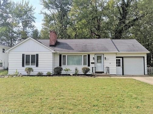
8400 Columbia Rd
Olmsted Falls, OH 44138
2 Weeks Ago
|
Edit
Favorites
8400 Columbia Rd

Favorites
Check Back Soon for Upcoming Availability
| Beds | Baths | Average SF |
|---|---|---|
| 3 Bedrooms 3 Bedrooms 3 Br | 1.5 Baths 1.5 Baths 1.5 Ba | — |
About This Property
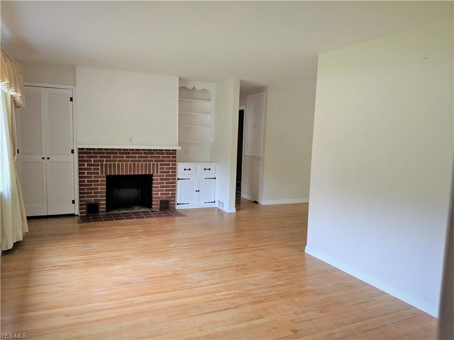
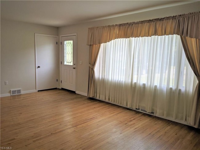
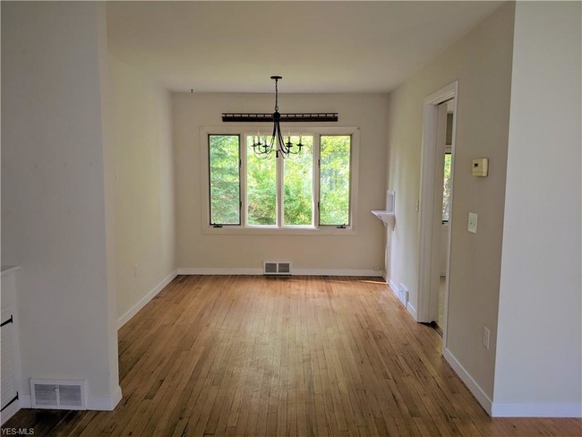
This LEASE to OWN opportunity is a cozy home backs up to a wooded lot containing Plum Creek making it your personal sanctuary. The house is well lit with neutral colors and boast hardwood floors throughout. The partially finished basement with walk-out is great for entertaining. The home has three bedrooms and one full and one half bath with plenty of storage to make it perfect for any buyer. Schedule a showing today it's definitely worth a look!
8400 Columbia Rd is a house located in Cuyahoga County and the 44138 ZIP Code. This area is served by the Olmsted Falls City School District attendance zone.
House Features
- Basement
8400 Columbia Rd,
Olmsted Falls,
OH
44138
Olmsted Falls sits about 19 miles southwest of Cleveland along the Rocky River, carrying the quiet confidence of a small Ohio city that has held onto its historic character without getting left behind. The Grand Pacific Junction district, a collection of repurposed historic buildings at the corner of Bagley and Columbia Roads, anchors community life and gives the city a sense of place that newer suburbs often lack. Cleveland Hopkins International Airport and the Ohio Turnpike are both close at hand, making this a practical base for anyone who needs regional access without sacrificing a calmer pace. The Olmsted Falls City School District draws consistent praise and adds to the city's strong civic identity.
The housing mix here leans toward single-family homes and smaller apartment communities, with rental options that tend to offer more space per dollar than you would find closer to downtown Cleveland.
Learn more about living in Olmsted Falls
Amenities
- Basement
Education
| Colleges & Universities | Distance | ||
|---|---|---|---|
| Colleges & Universities | Distance | ||
| Drive: | 9 min | 3.4 mi | |
| Drive: | 14 min | 6.4 mi | |
| Drive: | 20 min | 8.5 mi | |
| Drive: | 21 min | 9.6 mi |
8400 Columbia Rd is within 9 minutes or 3.4 miles from Baldwin - Wallace College. It is also near Cuyahoga C.C., West and Cuyahoga C.C., Western Campus.
Schools


Public Elementary School
Grades PK-5
Nearby
Public Elementary School
Grades K-5
Attendance Zone
Public Elementary School
Grades K-5
Attendance Zone
Public Middle School
Grades 6-8
Attendance Zone
Public High School
Grades 9-12
Attendance Zone
Private Elementary & Middle School
Grades PK-8
Nearby
Private High School
Grades 9-12
Nearby
School data provided by
 The GreatSchools Rating helps parents compare schools within a state based on a variety of school quality indicators and provides a helpful picture of how effectively each school serves all of its students. Ratings are on a scale of 1 (below average) to 10 (above average) and can include test scores, college readiness, academic progress, advanced courses, equity, discipline and attendance data. We also advise parents to visit schools, consider other information on school performance and programs, and consider family needs as part of the school selection process.
View GreatSchools Rating Methodology
Data provided by GreatSchools.org © 2026. All rights reserved.
View GreatSchools Rating Methodology
Data provided by GreatSchools.org © 2026. All rights reserved.
Transportation options available in Olmsted Falls include Airport Station, located 6.1 miles from 8400 Columbia Rd. 8400 Columbia Rd is near Cleveland-Hopkins International, located 6.7 miles or 15 minutes away.
| Transit / Subway | Distance | ||
|---|---|---|---|
| Transit / Subway | Distance | ||
| Drive: | 13 min | 6.1 mi | |
| Drive: | 13 min | 6.7 mi | |
| Drive: | 16 min | 8.8 mi | |
| Drive: | 19 min | 10.0 mi | |
| Drive: | 21 min | 10.9 mi |
| Commuter Rail | Distance | ||
|---|---|---|---|
| Commuter Rail | Distance | ||
|
|
Drive: | 24 min | 15.6 mi |
| Drive: | 30 min | 19.3 mi | |
|
|
Drive: | 33 min | 19.6 mi |
| Drive: | 32 min | 20.9 mi | |
| Drive: | 38 min | 24.6 mi |
| Airports | Distance | ||
|---|---|---|---|
| Airports | Distance | ||
|
Cleveland-Hopkins International
|
Drive: | 15 min | 6.7 mi |
Walkability Near 8400 Columbia Rd Olmsted Falls, OH 44138
Getting Around
 What do Walkability, Transit, Drivability, and Bikeability mean?
Walkability measures the walking distance to day-to-day needs.
Transit measures access to public transportation.
Drivability measures congestion, parking availability, and access to major roads.
Bikeability measures the suitability for cycling.
How It Works
What do Walkability, Transit, Drivability, and Bikeability mean?
Walkability measures the walking distance to day-to-day needs.
Transit measures access to public transportation.
Drivability measures congestion, parking availability, and access to major roads.
Bikeability measures the suitability for cycling.
How It Works
Fairly Walkable
Walkability
40
/ 100
Minimal Public Transit
Transit
0
/ 100
Exceptionally Drivable
Drivability
100
/ 100
Somewhat Bikeable
Bikeability
30
/ 100
Scores provided by
Busy
Soundscore™
67
/ 100
Traffic
BusyAirport
BusyBusinesses
CalmScores provided by
HowLoud What is a Sound Score Rating? A Sound Score Rating aggregates noise caused by vehicle traffic, airplane traffic and local sources. How It WorksTime and distance from 8400 Columbia Rd.
| Shopping Centers | Distance | ||
|---|---|---|---|
| Shopping Centers | Distance | ||
| Walk: | 5 min | 0.3 mi | |
| Walk: | 15 min | 0.8 mi | |
| Drive: | 3 min | 1.3 mi |
8400 Columbia Rd has 3 shopping centers within 1.3 miles, which is about a 3-minute drive. The miles and minutes will be for the farthest away property.
| Parks and Recreation | Distance | ||
|---|---|---|---|
| Parks and Recreation | Distance | ||
|
Rocky River Nature Center
|
Drive: | 10 min | 4.1 mi |
|
Columbia Reservation
|
Drive: | 8 min | 4.7 mi |
|
Bradley Woods Reservation
|
Drive: | 12 min | 5.9 mi |
|
Gardenview Horticultural Park
|
Drive: | 17 min | 8.5 mi |
|
Mill Stream Run Reservation
|
Drive: | 18 min | 9.9 mi |
8400 Columbia Rd has 5 parks within 9.9 miles, including Rocky River Nature Center, Columbia Reservation, and Bradley Woods Reservation.
| Hospitals | Distance | ||
|---|---|---|---|
| Hospitals | Distance | ||
| Drive: | 9 min | 3.8 mi | |
| Drive: | 12 min | 6.0 mi | |
| Drive: | 17 min | 9.6 mi |
8400 Columbia Rd has 3 hospitals within 9.6 miles, the nearest is Southwest General Health Center which is 3.8 miles away and a 9 minute drive.
| Military Bases | Distance | ||
|---|---|---|---|
| Military Bases | Distance | ||
| Drive: | 89 min | 70.2 mi | |
| Drive: | 89 min | 72.3 mi |
8400 Columbia Rd is 70.2 miles from Camp Perry Air Guard Station, and is convenient to other military bases, including Mansfield Lahm Airport Air Guard Station.
You May Also Like
Similar Rentals Nearby


What Are Walk Score®, Transit Score®, and Bike Score® Ratings?
Walk Score® measures the walkability of any address. Transit Score® measures access to public transit. Bike Score® measures the bikeability of any address.
What is a Sound Score Rating?
A Sound Score Rating aggregates noise caused by vehicle traffic, airplane traffic and local sources.
8400 Columbia Rd
Olmsted Falls, OH 44138