
MODA
153-30 89th Ave,
Jamaica, NY 11432
$3,195 - $3,502
2 Beds


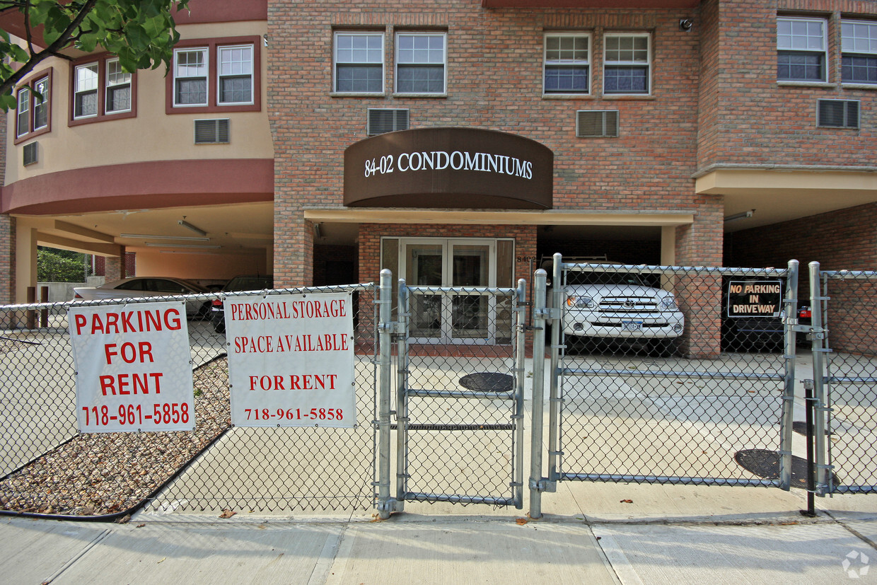

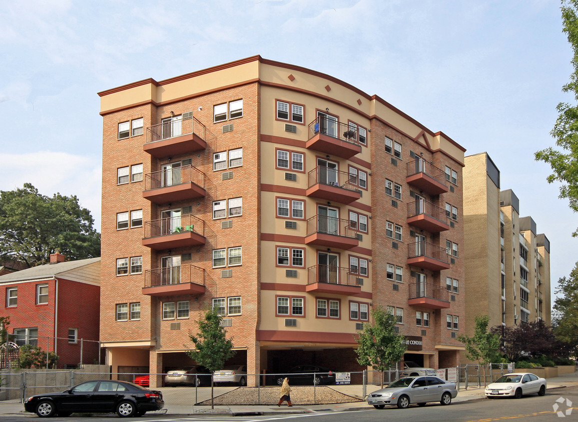
Experience Briarwood living at 84-02 143rd St. You'll find this community at 84-02 143rd St. in the 11435 area of Briarwood. Let the leasing team show you everything this community has to offer. Discover a great selection of amenities. Stop by the leasing office to learn more about our community.
84-02 143rd St is an apartment community located in Queens County and the 11435 ZIP Code. This area is served by the New York City Geographic District #28 attendance zone.
Washer/Dryer
Air Conditioning
High Speed Internet Access
Smoke Free
Tucked into southwest Queens just northwest of downtown Jamaica, Briarwood features tree-lined streets that create a quieter residential feel than much of the borough. Named for the heavily wooded land it once was, the neighborhood developed in the 1920s and maintains an established character. Van Wyck Expressway borders it west, while Union Turnpike and Hillside Avenue frame the northern and southern edges. Flushing Meadows-Corona Park and Jamaica Center sit within easy reach, offering green space and shopping nearby.
The E and F subway lines serve Briarwood at the Briarwood/Van Wyck Boulevard station, putting Midtown Manhattan about 30 minutes away. The rental market consists primarily of well-maintained mid-rise apartment communities and co-op buildings, plus attached brick homes and multi-family houses typical of classic Queens architecture. Jamaica Hospital Medical Center anchors healthcare services in the area. St.
Learn more about living in BriarwoodCompare neighborhood and city base rent averages by bedroom.
| Southeast Queens | Briarwood, NY | |
|---|---|---|
| Studio | $1,689 | $1,271 |
| 1 Bedroom | $2,108 | $1,835 |
| 2 Bedrooms | $2,658 | $2,364 |
| 3 Bedrooms | $3,260 | - |
| Colleges & Universities | Distance | ||
|---|---|---|---|
| Colleges & Universities | Distance | ||
| Drive: | 5 min | 1.6 mi | |
| Drive: | 6 min | 2.1 mi | |
| Drive: | 7 min | 2.6 mi | |
| Drive: | 11 min | 5.5 mi |


Transportation options available in Briarwood include Briarwood-Van Wyck Boulevard, located 0.5 mile from 84-02 143rd St. 84-02 143rd St is near LaGuardia, located 6.3 miles or 12 minutes away, and John F Kennedy International, located 6.7 miles or 10 minutes away.
| Transit / Subway | Distance | ||
|---|---|---|---|
| Transit / Subway | Distance | ||
|
|
Walk: | 9 min | 0.5 mi |
|
|
Walk: | 11 min | 0.6 mi |
|
|
Walk: | 15 min | 0.8 mi |
|
|
Walk: | 16 min | 0.9 mi |
|
|
Walk: | 18 min | 1.0 mi |
| Commuter Rail | Distance | ||
|---|---|---|---|
| Commuter Rail | Distance | ||
|
|
Walk: | 19 min | 1.0 mi |
|
|
Drive: | 4 min | 1.2 mi |
|
|
Drive: | 6 min | 2.0 mi |
|
|
Drive: | 6 min | 2.7 mi |
|
|
Drive: | 7 min | 3.2 mi |
| Airports | Distance | ||
|---|---|---|---|
| Airports | Distance | ||
|
LaGuardia
|
Drive: | 12 min | 6.3 mi |
|
John F Kennedy International
|
Drive: | 10 min | 6.7 mi |
Scores provided by
Traffic
BusyAirport
CalmBusinesses
BusyScores provided by
HowLoud What is a Sound Score Rating? A Sound Score Rating aggregates noise caused by vehicle traffic, airplane traffic and local sources. How It WorksTime and distance from 84-02 143rd St.
| Shopping Centers | Distance | ||
|---|---|---|---|
| Shopping Centers | Distance | ||
| Drive: | 3 min | 1.1 mi | |
| Drive: | 3 min | 1.1 mi | |
| Drive: | 4 min | 1.4 mi |
| Parks and Recreation | Distance | ||
|---|---|---|---|
| Parks and Recreation | Distance | ||
|
Rufus King Park
|
Drive: | 4 min | 1.5 mi |
|
Detective Keith L. Williams Park
|
Drive: | 6 min | 2.4 mi |
|
Forest Park - Brooklyn-Queens
|
Drive: | 5 min | 2.5 mi |
|
Kissena Park
|
Drive: | 8 min | 3.1 mi |
|
Flushing Meadows Corona Park
|
Drive: | 8 min | 4.2 mi |
| Hospitals | Distance | ||
|---|---|---|---|
| Hospitals | Distance | ||
| Walk: | 16 min | 0.9 mi | |
| Walk: | 17 min | 0.9 mi | |
| Drive: | 8 min | 3.6 mi |
| Military Bases | Distance | ||
|---|---|---|---|
| Military Bases | Distance | ||
| Drive: | 15 min | 8.4 mi | |
| Drive: | 24 min | 14.0 mi | |
| Drive: | 32 min | 15.5 mi |
What Are Walk Score®, Transit Score®, and Bike Score® Ratings?
Walk Score® measures the walkability of any address. Transit Score® measures access to public transit. Bike Score® measures the bikeability of any address.
What is a Sound Score Rating?
A Sound Score Rating aggregates noise caused by vehicle traffic, airplane traffic and local sources.
84-02 143rd St
Briarwood, NY 11435


