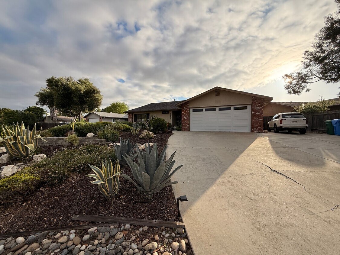
$3,650 / Month

835 Nicklaus St

,

Paso Robles, CA 93446

Today
| Edit

Under 30 minutes

Commute Time is calculated at rush hour.
Share Listing
Favorites
805-238-3055
  • Bedrooms

    3

  • Bathrooms

    2

  • Square Feet

    1,576 sq ft

  • Available

    Available May 16

835 Nicklaus St
Share Listing
Favorites

About This Home

$3,650 deposit, Available May 16

Welcome to this beautifully upgraded 3-bedroom, 2-bath ranch-style home located in a desirable Paso Robles neighborhood. Situated on an elevated 10,000 sq ft corner lot, this 1,576 sq ft home offers space, comfort, and exceptional indoor-outdoor living. Prime Location Walking distance to Pat Butler Elementary & Paso Robles High School Ideal for families Quiet, established neighborhood Spacious & Upgraded Interior Enjoy a bright, open layout designed for both relaxing and entertaining: New windows in living room and bedrooms Hand-textured walls and ceilings with bullnose edging Vinyl flooring throughout Slab granite countertops & stainless steel appliances Updated fixtures and finishes Remodeled primary bathroom with dual shower Central A/C and heating Outdoor Living & Entertaining Large private backyard with covered patio Custom pizza oven—perfect for hosting Terraced orchard with cherry, plum, and apricot trees Low-maintenance landscaping Additional Features Two-car garage with new epoxy floors Washer & dryer included RV or trailer parking Solar panels to help keep summer electricity costs low *Shown by appointments to qualified applicants only* *DO NOT DISTURB TENANTS*

Unique Features

  • Big Backyard
  • Boat/RV Parking
  • Central Heating and A/C
  • Granite Countertops
  • Pizza Oven
  • Vinyl Plank Flooring

835 Nicklaus St is a house located in San Luis Obispo County and the 93446 ZIP Code.

* Price shown is base rent. Excludes user-selected optional fees and variable or usage-based fees and required charges due at or prior to move-in or at move-out. Price, availability, fees, and any applicable rent special are subject to change without notice.
* Square footage definitions vary. Displayed square footage is approximate.

Contact

  • Listed by Suite
  • Phone Number
  • Contact
City - Paso Robles

Cradled in the coastal mountain range of Central California, Paso Robles sits about halfway between San Francisco and Los Angeles, serving as a gateway to vibrant metropolitan areas. Paso Robles is famous in its own right, best known for its thriving wineries and vineyards in addition to its healing hot springs. Located on the Salinas River, Paso Robles offers residents and visitors access to plenty of recreational opportunities in its local parks and golf courses as well as the nearby mountains, beaches, and deserts.

Paso Robles maintains a small-town charm, hosting dozens of annual events for the community such as the California Mid-State Fair, Olive Festival, Lavender Festival, and the Zinfandel Festival. Paso Robles also boasts a historic downtown area brimming with boutiques, wine tasting rooms, and local restaurants. Getting around from Paso Robles is easy with convenience to U.S. 101, Route 46, Paso Robles Intermodal Station, and Paso Robles Municipal Airport.

Learn more about living in Paso Robles 
Amenities
  • Big Backyard
  • Boat/RV Parking
  • Central Heating and A/C
  • Granite Countertops
  • Pizza Oven
  • Vinyl Plank Flooring
Education
Colleges & Universities Distance
Drive: 9 min 4.4 mi
Drive: 37 min 29.2 mi
Drive: 44 min 34.0 mi
835 Nicklaus St is within 9 minutes or 4.4 miles from Cuesta College, North County. It is also near Cal Poly and Cuesta Coll., San Luis Obispo.
Transportation

835 Nicklaus St is near San Luis County Regional, located 34.8 miles or 47 minutes away.

Commuter Rail Distance
Drive: 5 min 2.3 mi
Drive: 38 min 29.6 mi
Drive: 53 min 42.6 mi
Airports Distance
Airports Distance
San Luis County Regional
Drive: 47 min 34.8 mi
Getting Around
Fairly Walkable
Walkability
40 / 100
Limited Public Transit
Transit
30 / 100
Very Drivable
Drivability
80 / 100
Fairly Bikeable
Bikeability
40 / 100

Scores provided by

What do Walkability, Transit, Drivability, and Bikeability mean? Walkability measures the walking distance to day-to-day needs. Transit measures access to public transportation. Drivability measures congestion, parking availability, and access to major roads. Bikeability measures the suitability for cycling. How It Works
-
Soundscore
- / 100

Traffic

-

Airport

-

Businesses

-

Scores provided by

HowLoud What is a Sound Score Rating? A Sound Score Rating aggregates noise caused by vehicle traffic, airplane traffic and local sources. How It Works
Points of Interest

Time and distance from 835 Nicklaus St.

Shopping Centers Distance
Drive: 3 min 1.1 mi
Drive: 3 min 1.3 mi
Drive: 3 min 1.4 mi
835 Nicklaus St has 3 shopping centers within 1.4 miles, which is about a 3-minute drive. The miles and minutes will be for the farthest away property.
Parks and Recreation Distance
Children's Museum-Paso Robles Firehouse
Drive: 5 min 2.5 mi
Charles Paddock Zoo
Drive: 18 min 13.4 mi
835 Nicklaus St has 2 parks within 13.4 miles, including Children's Museum-Paso Robles Firehouse, and Charles Paddock Zoo.
Hospitals Distance
Hospitals Distance
Drive: 10 min 6.6 mi
835 Nicklaus St is 6.6 miles and a 10 minute drive from Twin Cities Community Hospital.
Military Bases Distance
Drive: 51 min 35.6 mi
835 Nicklaus St is 35.6 miles and a 51 minute drive from Camp San Luis Obispo Military Reservation.

You May Also Like

Similar Rentals Nearby