
$12,000
/ Month
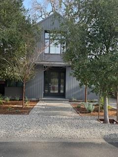
829 La Para Ave
Palo Alto, CA 94306
Today
|
Edit
Favorites
-
Bedrooms
4
-
Bathrooms
3.5
-
Square Feet
2,579 sq ft
-
Available
Available Feb 5
829 La Para Ave

Favorites
About This Home
Available Feb 5
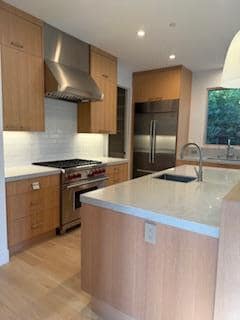
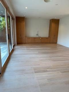
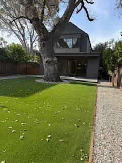
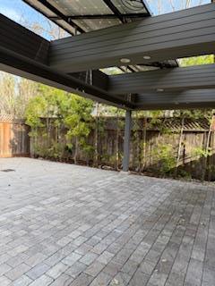
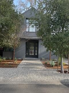
Elegant contemporary residence offering refined design built in 2018, offering seamless indoor-outdoor living. The main level features an en suite bedroom and a dedicated office, thoughtfully separated from the primary living spaces. An open-concept floor plan highlights a chefs kitchen and family room with expansive views of the generous backyard and outdoor entertaining areas. The kitchen is appointed with a Sub-Zero refrigerator, Bosch dishwasher, built-in microwave, gas cooktop/oven, pantry, breakfast bar. Laundry room and mudroom are located off the kitchen. Radiant floor heating throughout the main level. Upstairs, the tranquil primary suite overlooks the backyard and features a spacious walk-in closet, along with two additional bedrooms and a full bath. The upper level offers central forced-air heat and A/C. Complimentary Xfinity broadband (300 Mbps), Sonos audio in the primary bedroom, family room, and patio, and solar panels to help offset electrical costs. Gardener included. Tenant responsible for all utilities, including water, garbage, and recycling. No pets. Tenant qualifications: minimum credit score of 700 per applicant; verifiable gross household income of at least 3 times the monthly rent; positive landlord references; and employment verification MLS # ML82033642
829 La Para Ave is a house located in Santa Clara County and the 94306 ZIP Code.
* Price shown is base rent. Excludes user-selected optional fees and variable or usage-based fees and required charges due at or prior to move-in or at move-out. Price, availability, fees, and any applicable rent special are subject to change without notice.
* Square footage definitions vary. Displayed square footage is approximate.
Contact
- Listed by Ciana Megan Tierney | Compass
- Contact
-
Source
 MLSListings Inc.
Copyright © 2026 MLSListings Inc.
Location
Get Directions
Living in Palo Alto places you in Silicon Valley, where historic neighborhoods complement the city's technological presence. Tree-lined streets wind through the community, which is anchored by Stanford University. University Avenue features local boutiques and restaurants housed in preserved historic buildings, while the Stanford Shopping Center offers high-end retail destinations. The city maintains 36 parks and preserves, including the Baylands Nature Preserve and Foothills Park, where residents enjoy hiking trails and outdoor activities. Palo Alto's infrastructure supports alternative transportation, with dedicated bike lanes throughout the city.
The rental market in Palo Alto reflects the area's popularity, with current average rents ranging from $2,634 for studios to $6,139 for four-bedroom homes. Recent trends show steady growth, with rent increases varying from 1.8% to 17% across different unit sizes over the past year.
Learn more about living in Palo Alto
Education
| Colleges & Universities | Distance | ||
|---|---|---|---|
| Colleges & Universities | Distance | ||
| Drive: | 8 min | 2.4 mi | |
| Drive: | 9 min | 3.1 mi | |
| Drive: | 13 min | 5.3 mi | |
| Drive: | 13 min | 5.3 mi |
829 La Para Ave is within 8 minutes or 2.4 miles from Foothill College, Middlefield. It is also near Stanford University and Foothill Coll., Los Altos.
Transportation options available in Palo Alto include Mountain View Station, located 3.9 miles from 829 La Para Ave. 829 La Para Ave is near Norman Y Mineta San Jose International, located 13.2 miles or 22 minutes away, and San Francisco International, located 23.9 miles or 34 minutes away.
| Transit / Subway | Distance | ||
|---|---|---|---|
| Transit / Subway | Distance | ||
| Drive: | 8 min | 3.9 mi | |
|
|
Drive: | 8 min | 3.9 mi |
|
|
Drive: | 11 min | 5.2 mi |
| Drive: | 12 min | 5.7 mi | |
|
|
Drive: | 13 min | 5.9 mi |
| Commuter Rail | Distance | ||
|---|---|---|---|
| Commuter Rail | Distance | ||
| Drive: | 5 min | 1.9 mi | |
| Drive: | 6 min | 2.2 mi | |
| Drive: | 6 min | 2.4 mi | |
| Drive: | 9 min | 3.4 mi | |
| Drive: | 11 min | 4.5 mi |
| Airports | Distance | ||
|---|---|---|---|
| Airports | Distance | ||
|
Norman Y Mineta San Jose International
|
Drive: | 22 min | 13.2 mi |
|
San Francisco International
|
Drive: | 34 min | 23.9 mi |
Time and distance from 829 La Para Ave.
| Shopping Centers | Distance | ||
|---|---|---|---|
| Shopping Centers | Distance | ||
| Drive: | 3 min | 1.1 mi | |
| Drive: | 4 min | 1.5 mi | |
| Drive: | 5 min | 2.0 mi |
829 La Para Ave has 3 shopping centers within 2.0 miles, which is about a 5-minute drive. The miles and minutes will be for the farthest away property.
| Parks and Recreation | Distance | ||
|---|---|---|---|
| Parks and Recreation | Distance | ||
|
Bol Park
|
Walk: | 8 min | 0.4 mi |
|
Terman Park
|
Drive: | 4 min | 1.3 mi |
|
J. Pearce Mitchell Park
|
Drive: | 6 min | 1.7 mi |
|
Esther Clark Nature Preserve
|
Drive: | 7 min | 2.3 mi |
|
Gamble Garden
|
Drive: | 7 min | 2.8 mi |
829 La Para Ave has 5 parks within 2.8 miles, including Bol Park, Terman Park, and J. Pearce Mitchell Park.
| Hospitals | Distance | ||
|---|---|---|---|
| Hospitals | Distance | ||
| Drive: | 10 min | 3.8 mi | |
| Drive: | 11 min | 4.3 mi | |
| Drive: | 12 min | 5.2 mi |
829 La Para Ave has 3 hospitals within 5.2 miles, the nearest is Lucile Salter Packard Children's Hospital at Stanford which is 3.8 miles away and a 10 minute drive.
| Military Bases | Distance | ||
|---|---|---|---|
| Military Bases | Distance | ||
| Drive: | 15 min | 6.1 mi |
829 La Para Ave is 6.1 miles and a 15 minute drive from Ames Research Center.
You May Also Like
Similar Rentals Nearby


What Are Walk Score®, Transit Score®, and Bike Score® Ratings?
Walk Score® measures the walkability of any address. Transit Score® measures access to public transit. Bike Score® measures the bikeability of any address.
What is a Sound Score Rating?
A Sound Score Rating aggregates noise caused by vehicle traffic, airplane traffic and local sources
829 La Para Ave
Palo Alto, CA 94306