
$2,225
/ Month
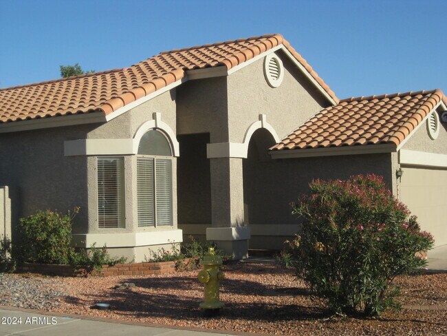
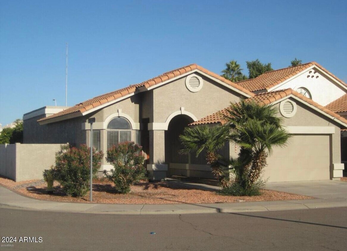
825 N Cholla St
Chandler, AZ 85224
2 Weeks Ago
|
Edit
Favorites
825 N Cholla St

Favorites
Check Back Soon for Upcoming Availability
| Beds | Baths | Average SF |
|---|---|---|
| 3 Bedrooms 3 Bedrooms 3 Br | 2 Baths 2 Baths 2 Ba | 1,500 SF |
About This Property
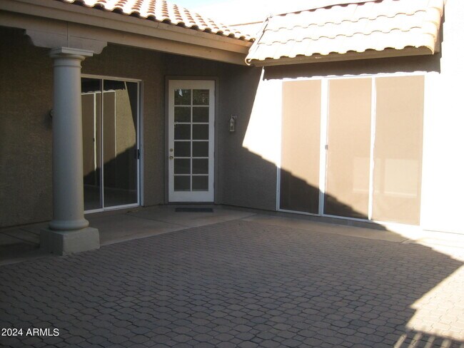
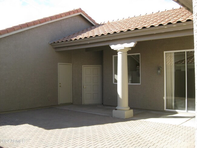
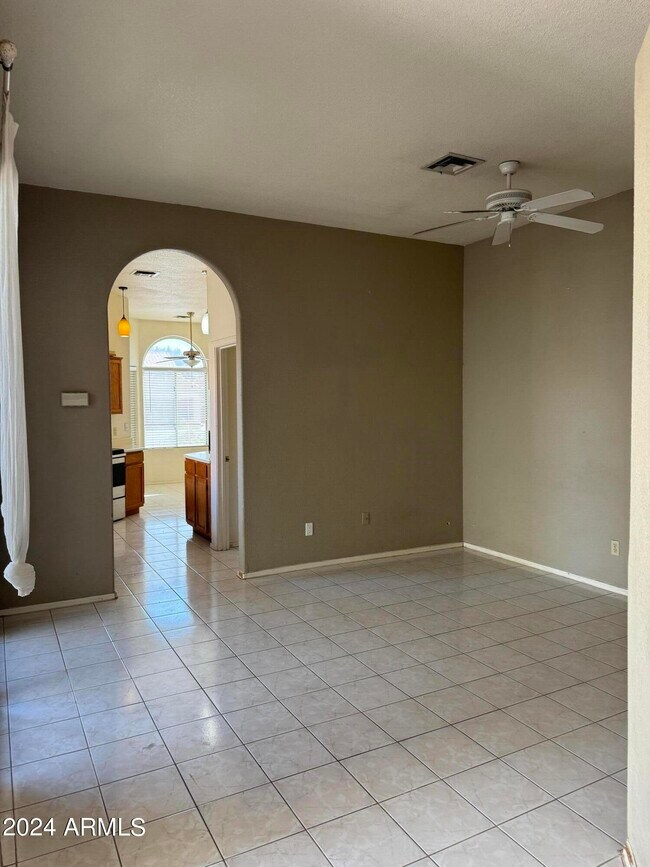
Corner lot three lovely bedrooms & two bathrooms house with huge enclosed courtyard great for entertaining. New floor and fresh paint throughout the house. Great room is light & bright with a cozy fireplace! Relax in the garden tub in the master bath. Formal dining room presently used as a family/TV room. Front/back yards have desert landscaping,yet courtyard has nice pavers area. North and South exposure,easy access to 101 & I-60. Convenient to shopping,new mall,restaurants,hospital & park/greenbelt,202 San Tan Freeway,Chandler Fashion Center,Andersen Spring Neighborhood known for lakes,greenbelt,restaurants (Pita Jungle,Sushi,Valle Luna,etc. Walk to Fry's and Sprouts Farmer Market.
825 N Cholla St is a house located in Maricopa County and the 85224 ZIP Code. This area is served by the Chandler Unified District attendance zone.
Location
Get Directions
Fashionistas that live in the North Chandler area will appreciate the close proximity to Chandler Fashion Center. This mall has a varied selection of stores, which range from affordable to high-end. When it comes to groceries, residents have their choice of international supermarkets, or can opt for the organic Whole Foods Market.
If golf is your passion, then you’ll love tee time at San Marcos Golf Course. The neighborhood and surrounding area is encompassed with parks, including Arrowhead Meadows Park and Brooks Crossing Park – all great for outdoor recreational activities. The Perch Brewery is an excellent place for local craft beer as well as birdwatching. This North Chandler pub has more than forty beers on tap, and is the home of over fifty exotic rescue birds. Looking for something yummy to eat? Be sure to try Bella Gusto Urban Pizzeria, Elvira’s Belizean Café, Filiberto’s Mexican Food, Nishikawa Ramen, and Pho Viet Nam.
Learn more about living in North ChandlerBelow are rent ranges for similar nearby apartments
| Beds | Average Size | Lowest | Typical | Premium |
|---|---|---|---|---|
| Studio Studio Studio | 531-532 Sq Ft | $1,029 | $1,457 | $2,262 |
| 1 Bed 1 Bed 1 Bed | 753-754 Sq Ft | $1,117 | $1,726 | $11,596 |
| 2 Beds 2 Beds 2 Beds | 1025-1026 Sq Ft | $1,095 | $1,946 | $16,932 |
| 3 Beds 3 Beds 3 Beds | 1369 Sq Ft | $1,745 | $2,790 | $23,770 |
| 4 Beds 4 Beds 4 Beds | 2053 Sq Ft | $750 | $3,009 | $8,704 |
Education
| Colleges & Universities | Distance | ||
|---|---|---|---|
| Colleges & Universities | Distance | ||
| Drive: | 12 min | 5.8 mi | |
| Drive: | 12 min | 6.0 mi | |
| Drive: | 14 min | 7.0 mi | |
| Drive: | 15 min | 7.8 mi |
825 N Cholla St is within 12 minutes or 5.8 miles from Mesa C.C., Southern and Dobson. It is also near Alverno College and Chandler-Gilbert C.C., Pecos.
Schools


Public Elementary School
Grades PK-6
760 Students
Attendance Zone
Public Middle & High School
Grades 8-12
3,597 Students
Attendance Zone
Public Middle School
Grades 6-8
728 Students
Attendance Zone
Private Elementary School
Grades PK-6
Nearby
Private Elementary & Middle School
Grades K-8
121 Students
Nearby
Private High School
Grades 9-12
571 Students
Nearby
School data provided by
 The GreatSchools Rating helps parents compare schools within a state based on a variety of school quality indicators and provides a helpful picture of how effectively each school serves all of its students. Ratings are on a scale of 1 (below average) to 10 (above average) and can include test scores, college readiness, academic progress, advanced courses, equity, discipline and attendance data. We also advise parents to visit schools, consider other information on school performance and programs, and consider family needs as part of the school selection process.
View GreatSchools Rating Methodology
Data provided by GreatSchools.org © 2025. All rights reserved.
View GreatSchools Rating Methodology
Data provided by GreatSchools.org © 2025. All rights reserved.
Transportation options available in Chandler include Alma School/Main St, located 7.5 miles from 825 N Cholla St. 825 N Cholla St is near Phoenix-Mesa Gateway, located 12.8 miles or 24 minutes away, and Phoenix Sky Harbor International, located 16.4 miles or 24 minutes away.
| Transit / Subway | Distance | ||
|---|---|---|---|
| Transit / Subway | Distance | ||
|
|
Drive: | 14 min | 7.5 mi |
|
|
Drive: | 12 min | 8.3 mi |
|
|
Drive: | 15 min | 8.5 mi |
|
|
Drive: | 13 min | 8.8 mi |
|
|
Drive: | 14 min | 9.4 mi |
| Commuter Rail | Distance | ||
|---|---|---|---|
| Commuter Rail | Distance | ||
|
|
Drive: | 34 min | 24.1 mi |
| Airports | Distance | ||
|---|---|---|---|
| Airports | Distance | ||
|
Phoenix-Mesa Gateway
|
Drive: | 24 min | 12.8 mi |
|
Phoenix Sky Harbor International
|
Drive: | 24 min | 16.4 mi |
Time and distance from 825 N Cholla St.
| Shopping Centers | Distance | ||
|---|---|---|---|
| Shopping Centers | Distance | ||
| Walk: | 11 min | 0.6 mi | |
| Walk: | 12 min | 0.6 mi | |
| Walk: | 15 min | 0.8 mi |
825 N Cholla St has 3 shopping centers within 0.8 mile, which is about a 15-minute walk. The miles and minutes will be for the farthest away property.
| Parks and Recreation | Distance | ||
|---|---|---|---|
| Parks and Recreation | Distance | ||
|
Pecos Park
|
Drive: | 16 min | 8.1 mi |
|
i.d.e.a. Museum
|
Drive: | 15 min | 8.7 mi |
|
Arizona Museum of Natural History
|
Drive: | 16 min | 9.0 mi |
|
South Mountain Park
|
Drive: | 20 min | 10.0 mi |
|
ASU Center for Meteorite Studies
|
Drive: | 18 min | 11.4 mi |
825 N Cholla St has 5 parks within 11.4 miles, including Pecos Park, i.d.e.a. Museum, and Arizona Museum of Natural History.
| Hospitals | Distance | ||
|---|---|---|---|
| Hospitals | Distance | ||
| Drive: | 4 min | 1.8 mi | |
| Drive: | 5 min | 2.5 mi | |
| Drive: | 6 min | 2.9 mi |
825 N Cholla St has 3 hospitals within 2.9 miles, the nearest is Chandler Regional Medical Center which is 1.8 miles away and a 4 minute drive.
| Military Bases | Distance | ||
|---|---|---|---|
| Military Bases | Distance | ||
| Drive: | 25 min | 17.2 mi | |
| Drive: | 54 min | 41.7 mi | |
| Drive: | 103 min | 82.9 mi |
825 N Cholla St has 3 military bases within 82.9 miles, the nearest is Phoenix Sky Harbor Airport Air Guard Station which is 17.2 miles away and a 25 minute drive.
You May Also Like
Similar Rentals Nearby


What Are Walk Score®, Transit Score®, and Bike Score® Ratings?
Walk Score® measures the walkability of any address. Transit Score® measures access to public transit. Bike Score® measures the bikeability of any address.
What is a Sound Score Rating?
A Sound Score Rating aggregates noise caused by vehicle traffic, airplane traffic and local sources
825 N Cholla St
Chandler, AZ 85224