

$2,900
/ Month
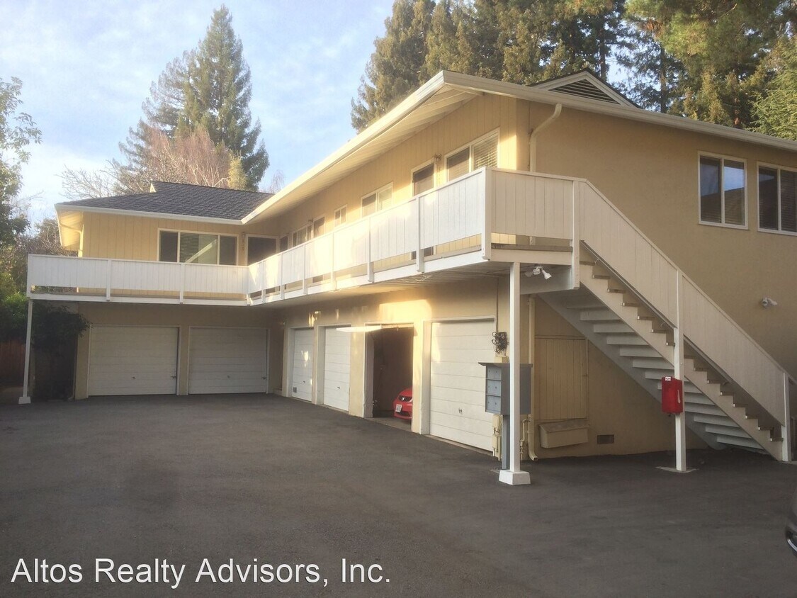
817-829 University Ave
Palo Alto, CA 94301
2 Weeks Ago
|
Edit
Favorites
817-829 University Ave

Favorites
Check Back Soon for Upcoming Availability
| Beds | Baths | Average SF |
|---|---|---|
| 1 Bedroom 1 Bedroom 1 Br | 1 Bath 1 Bath 1 Ba | 650 SF |
About This Property
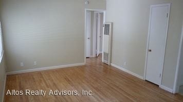
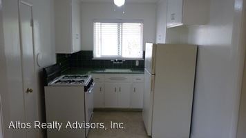
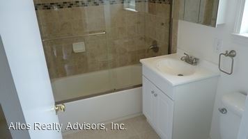
(408) 720-0920 x108 - 1 Bed 1 Bath Downtown Palo Alto University Ave 1 Car Garage - This 1 Bedroom downtown Palo Alto apartment features over 650 square feet of living space in a quiet complex on a private driveway. It features 1 bedroom and 1 bathroom with a large living room, storage unit, and 1 car garage with automatic opener. This apartment is centrally located at the cross streets of Guinda and University Ave, blocks from all that University Ave has to offer. In very close proximity to all the restaurants and shopping in downtown Palo Alto. Very close to 101 and Palo Alto Caltrain Station. This unit is a must see! Parking 1 Car Garage Street Pets No Pets Laundry Common HVAC Furnace Heating Unit Utilities Water & Garbage Included Tenant responsible for other utilities If this doesn’t quite meet your needs, check out our other available properties at www.compassproperty.com or give us a call at 408-720-0920. (RLNE3508344)
817-829 University Ave is an apartment community located in Santa Clara County and the 94301 ZIP Code.
Location
Get Directions
Living in Palo Alto places you in Silicon Valley, where historic neighborhoods complement the city's technological presence. Tree-lined streets wind through the community, which is anchored by Stanford University. University Avenue features local boutiques and restaurants housed in preserved historic buildings, while the Stanford Shopping Center offers high-end retail destinations. The city maintains 36 parks and preserves, including the Baylands Nature Preserve and Foothills Park, where residents enjoy hiking trails and outdoor activities. Palo Alto's infrastructure supports alternative transportation, with dedicated bike lanes throughout the city.
The rental market in Palo Alto reflects the area's popularity, with current average rents ranging from $2,634 for studios to $6,139 for four-bedroom homes. Recent trends show steady growth, with rent increases varying from 1.8% to 17% across different unit sizes over the past year.
Learn more about living in Palo AltoBelow are rent ranges for similar nearby apartments
Education
| Colleges & Universities | Distance | ||
|---|---|---|---|
| Colleges & Universities | Distance | ||
| Drive: | 9 min | 2.7 mi | |
| Drive: | 8 min | 2.9 mi | |
| Drive: | 10 min | 5.3 mi | |
| Drive: | 18 min | 8.3 mi |
817-829 University Ave is within 9 minutes or 2.7 miles from Stanford University. It is also near Menlo College and Foothill College, Middlefield.
Transportation options available in Palo Alto include Bayshore Nasa Station, located 7.6 miles from 817-829 University Ave. 817-829 University Ave is near Norman Y Mineta San Jose International, located 15.2 miles or 21 minutes away, and San Francisco International, located 20.1 miles or 28 minutes away.
| Transit / Subway | Distance | ||
|---|---|---|---|
| Transit / Subway | Distance | ||
| Drive: | 11 min | 7.6 mi | |
|
|
Drive: | 12 min | 7.7 mi |
| Drive: | 12 min | 8.0 mi | |
|
|
Drive: | 12 min | 8.0 mi |
|
|
Drive: | 13 min | 8.2 mi |
| Commuter Rail | Distance | ||
|---|---|---|---|
| Commuter Rail | Distance | ||
| Walk: | 18 min | 0.9 mi | |
| Drive: | 5 min | 2.0 mi | |
| Drive: | 6 min | 2.4 mi | |
| Drive: | 8 min | 3.0 mi | |
| Drive: | 11 min | 6.1 mi |
| Airports | Distance | ||
|---|---|---|---|
| Airports | Distance | ||
|
Norman Y Mineta San Jose International
|
Drive: | 21 min | 15.2 mi |
|
San Francisco International
|
Drive: | 28 min | 20.1 mi |
Time and distance from 817-829 University Ave.
| Shopping Centers | Distance | ||
|---|---|---|---|
| Shopping Centers | Distance | ||
| Drive: | 5 min | 1.4 mi | |
| Drive: | 5 min | 1.6 mi | |
| Drive: | 6 min | 1.8 mi |
817-829 University Ave has 3 shopping centers within 1.8 miles, which is about a 6-minute drive. The miles and minutes will be for the farthest away property.
| Parks and Recreation | Distance | ||
|---|---|---|---|
| Parks and Recreation | Distance | ||
|
Hopkins Creekside Park
|
Walk: | 15 min | 0.8 mi |
|
Junior Museum and Zoo
|
Walk: | 17 min | 0.9 mi |
|
Seminary Oaks Park
|
Drive: | 3 min | 1.1 mi |
|
Gamble Garden
|
Drive: | 4 min | 1.2 mi |
|
El Palo Alto Park
|
Drive: | 4 min | 1.3 mi |
817-829 University Ave has 5 parks within 1.3 miles, including Hopkins Creekside Park, Junior Museum and Zoo, and Seminary Oaks Park.
| Hospitals | Distance | ||
|---|---|---|---|
| Hospitals | Distance | ||
| Drive: | 6 min | 1.8 mi | |
| Drive: | 7 min | 2.4 mi | |
| Drive: | 11 min | 6.5 mi |
817-829 University Ave has 3 hospitals within 6.5 miles, the nearest is Lucile Salter Packard Children's Hospital at Stanford which is 1.8 miles away and a 6 minute drive.
| Military Bases | Distance | ||
|---|---|---|---|
| Military Bases | Distance | ||
| Drive: | 14 min | 8.0 mi |
817-829 University Ave is 8.0 miles and a 14 minute drive from Ames Research Center.
You May Also Like
Similar Rentals Nearby


What Are Walk Score®, Transit Score®, and Bike Score® Ratings?
Walk Score® measures the walkability of any address. Transit Score® measures access to public transit. Bike Score® measures the bikeability of any address.
What is a Sound Score Rating?
A Sound Score Rating aggregates noise caused by vehicle traffic, airplane traffic and local sources
817-829 University Ave
Palo Alto, CA 94301