$1,675 / Month
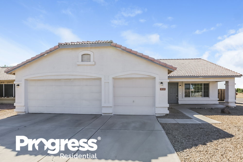
8119 W Citrus Way
Glendale, AZ 85303
2 Weeks Ago
Favorites
8119 W Citrus Way

Favorites
Check Back Soon for Upcoming Availability
| Beds | Baths | Average SF |
|---|---|---|
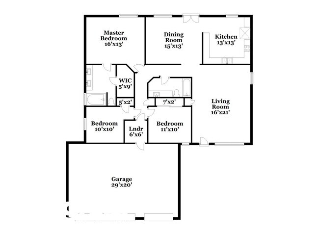
| 3 Bedrooms 3 Bedrooms 3 Br | 2.5 Baths 2.5 Baths 2.5 Ba | 1,598 SF |
Fees and Policies
The fees below are based on community-supplied data and may exclude additional fees and utilities.
- Dogs Allowed
-
Fees not specified
- Cats Allowed
-
Fees not specified
About This Property
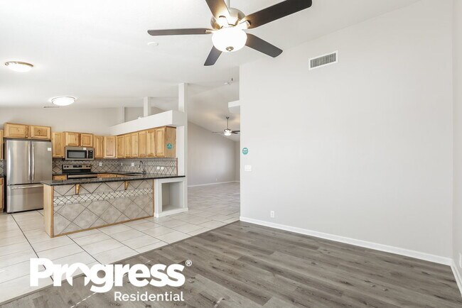
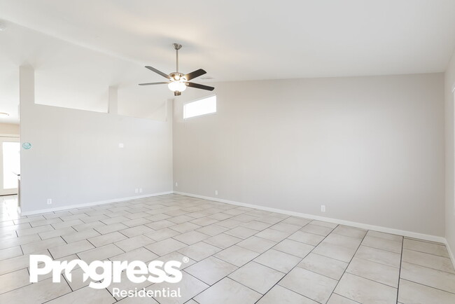
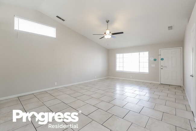
This home is priced to rent and won't be around for long. Apply now, while we make this home ready for you, or call to arrange a meeting with your local Progress Residential leasing specialist today. Easy living can be yours with this ranch-style rental home in Glendale. Enter the living room, and you'll notice the white tile flooring and vaulted ceiling with an overhead fan. The stylish kitchen boasts granite countertops, stainless steel appliances, and a striking backsplash. Dual vanity sinks and an oversized bathtub are just a few of the highlights of the master bathroom. This recently renovated home features a three-car garage for all your vehicle and storage needs. You will love spending time in the fenced backyard. It offers mature landscaping, a covered patio, and plenty of space to entertain. Call today to set up your tour. Note: The listed amenities may not be accurate. Please consult with a Progress Residential leasing agent to confirm the property will meet your individual needs.
8119 W Citrus Way is a house located in Maricopa County and the 85303 ZIP Code. This area is served by the Pendergast Elementary District attendance zone.
House Features
Walk-In Closets
Granite Countertops
Tile Floors
Stainless Steel Appliances
- Ceiling Fans
- Double Vanities
- Granite Countertops
- Stainless Steel Appliances
- Tile Floors
- Vaulted Ceiling
- Walk-In Closets
- Patio
Location
Get Directions
Westside is a neighborhood within Glendale, which was voted “Arizona’s Antique Capital” by Sunset magazine and USA Today. Many higher education schools are located near Westside, including Glendale Community College, Carrington College, and Arizona State University West campus. You’ll discover numerous pocket parks in the area, plus larger ones like Glendale Heroes Regional Park and Grand Canal Linear Park. Shopping and dining destinations are plentiful, especially at Arrowhead Towne Center Mall.
Learn more about living in WestsideBelow are rent ranges for similar nearby apartments
| Beds | Average Size | Lowest | Typical | Premium |
|---|---|---|---|---|
| Studio Studio Studio | 495 Sq Ft | $663 | $1,075 | $2,742 |
| 1 Bed 1 Bed 1 Bed | 675 Sq Ft | $705 | $1,415 | $11,912 |
| 2 Beds 2 Beds 2 Beds | 986-987 Sq Ft | $799 | $1,692 | $13,241 |
| 3 Beds 3 Beds 3 Beds | 1367-1369 Sq Ft | $1,156 | $2,240 | $22,216 |
| 4 Beds 4 Beds 4 Beds | 2139 Sq Ft | $1,300 | $3,400 | $22,950 |
Amenities
- Ceiling Fans
- Double Vanities
- Granite Countertops
- Stainless Steel Appliances
- Tile Floors
- Vaulted Ceiling
- Walk-In Closets
- Patio
Education
| Colleges & Universities | Distance | ||
|---|---|---|---|
| Colleges & Universities | Distance | ||
| Drive: | 13 min | 5.4 mi | |
| Drive: | 18 min | 7.9 mi | |
| Drive: | 20 min | 9.3 mi | |
| Drive: | 21 min | 10.0 mi |
8119 W Citrus Way is within 13 minutes or 5.4 miles from Glendale Community College. It is also near Grand Canyon University and Thunderbird, West Campus.
Schools


Public Elementary & Middle School
Grades PK-8
708 Students
Nearby
Public Elementary & Middle School
Grades K-8
629 Students
Attendance Zone
Public High School
Grades 9-12
2,040 Students
Attendance Zone
Private Elementary, Middle & High School
Grades 5-12
Nearby
Private Elementary & Middle School
Grades PK-8
116 Students
Nearby
School data provided by
 The GreatSchools Rating helps parents compare schools within a state based on a variety of school quality indicators and provides a helpful picture of how effectively each school serves all of its students. Ratings are on a scale of 1 (below average) to 10 (above average) and can include test scores, college readiness, academic progress, advanced courses, equity, discipline and attendance data. We also advise parents to visit schools, consider other information on school performance and programs, and consider family needs as part of the school selection process.
View GreatSchools Rating Methodology
Data provided by GreatSchools.org © 2025. All rights reserved.
View GreatSchools Rating Methodology
Data provided by GreatSchools.org © 2025. All rights reserved.
Transportation options available in Glendale include Glendale/19Th Ave, located 8.4 miles from 8119 W Citrus Way. 8119 W Citrus Way is near Phoenix Sky Harbor International, located 20.7 miles or 31 minutes away.
| Transit / Subway | Distance | ||
|---|---|---|---|
| Transit / Subway | Distance | ||
|
|
Drive: | 18 min | 8.4 mi |
|
|
Drive: | 18 min | 9.1 mi |
|
|
Drive: | 20 min | 9.8 mi |
|
|
Drive: | 20 min | 10.0 mi |
|
|
Drive: | 21 min | 10.2 mi |
| Commuter Rail | Distance | ||
|---|---|---|---|
| Commuter Rail | Distance | ||
|
|
Drive: | 63 min | 48.6 mi |
| Airports | Distance | ||
|---|---|---|---|
| Airports | Distance | ||
|
Phoenix Sky Harbor International
|
Drive: | 31 min | 20.7 mi |
Time and distance from 8119 W Citrus Way.
| Shopping Centers | Distance | ||
|---|---|---|---|
| Shopping Centers | Distance | ||
| Walk: | 12 min | 0.6 mi | |
| Walk: | 16 min | 0.8 mi | |
| Drive: | 4 min | 1.6 mi |
8119 W Citrus Way has 3 shopping centers within 1.6 miles, which is about a 4-minute walk. The miles and minutes will be for the farthest away property.
| Parks and Recreation | Distance | ||
|---|---|---|---|
| Parks and Recreation | Distance | ||
|
El Oso Park
|
Drive: | 9 min | 4.3 mi |
|
Maryvale Park
|
Drive: | 13 min | 6.6 mi |
|
Friendship Park
|
Drive: | 19 min | 10.9 mi |
|
Acoma Park
|
Drive: | 23 min | 11.5 mi |
|
Conocido Park
|
Drive: | 27 min | 13.5 mi |
8119 W Citrus Way has 5 parks within 13.5 miles, including El Oso Park, Maryvale Park, and Friendship Park.
| Hospitals | Distance | ||
|---|---|---|---|
| Hospitals | Distance | ||
| Drive: | 9 min | 5.0 mi | |
| Drive: | 12 min | 6.2 mi | |
| Drive: | 13 min | 7.9 mi |
8119 W Citrus Way has 3 hospitals within 7.9 miles, the nearest is Banner Estrella Medical Center which is 5.0 miles away and a 9 minute drive.
| Military Bases | Distance | ||
|---|---|---|---|
| Military Bases | Distance | ||
| Drive: | 14 min | 7.3 mi | |
| Drive: | 32 min | 20.6 mi | |
| Drive: | 94 min | 69.3 mi |
8119 W Citrus Way has 3 military bases within 69.3 miles, the nearest is Luke Air Force Base which is 7.3 miles away and a 14 minute drive.
You May Also Like
Similar Rentals Nearby


What Are Walk Score®, Transit Score®, and Bike Score® Ratings?
Walk Score® measures the walkability of any address. Transit Score® measures access to public transit. Bike Score® measures the bikeability of any address.
What is a Sound Score Rating?
A Sound Score Rating aggregates noise caused by vehicle traffic, airplane traffic and local sources

8119 W Citrus Way
Glendale, AZ 85303