
$2,980
/ Month
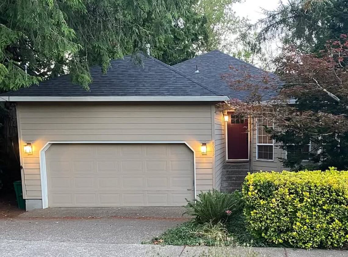
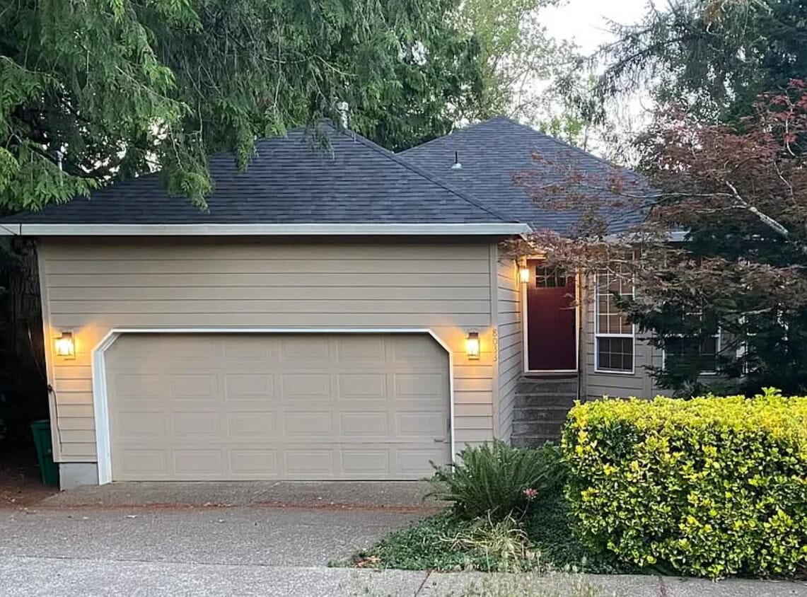
8033 SW Hemlock St
Tigard, OR 97223
Today
|
Edit
Favorites
503-810-8284
-
Bedrooms
3
-
Bathrooms
3
-
Square Feet
2,000 sq ft
-
Available
Available Now
8033 SW Hemlock St

Favorites
About This Home
$3,500 deposit,
Available Now
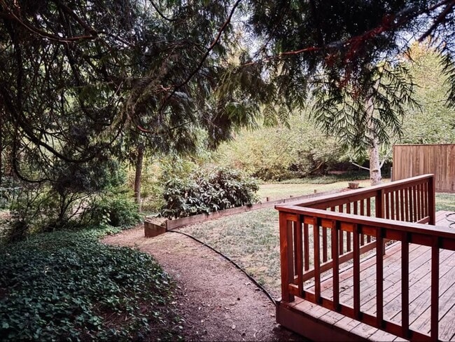
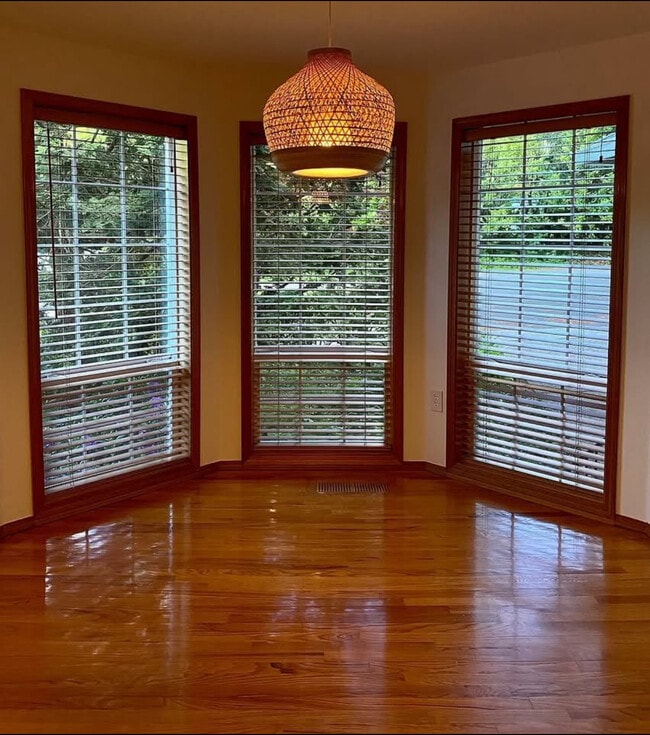
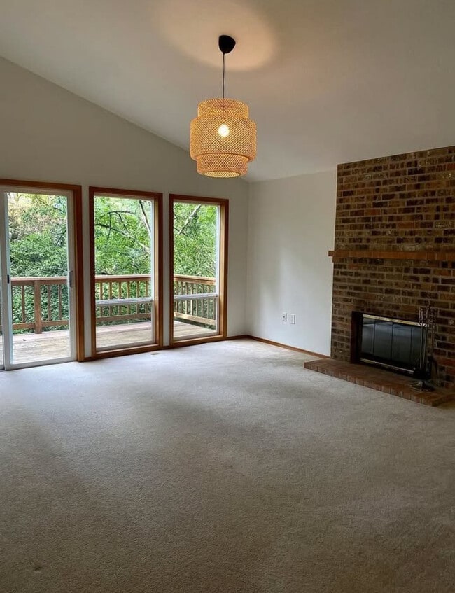
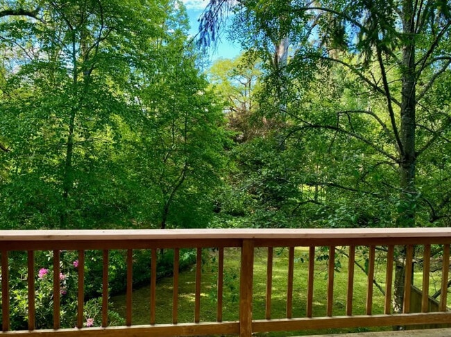
Stunning 3 Bed / 3 Bath Home with Wooded Views + Creek Access! ?? ? 2,000 sq ft | .25 Acre Fenced in Green Space | Finished Basement Fall in love with this immaculate home featuring: ? Vaulted ceiling & floor-to-ceiling windows ? Fireside family room + two decks with views of and access to Ash Creek ? Spacious bedrooms w/ walk-in closets ? Private downstairs suite with full bath & second living room ? Large fenced yard, perfect for entertaining ? Central A/C + two furnaces (one per level) ? 2-car garage & tons of storage ? Close to OHSU and a quick drive to Intel and Nike ??Just a short walk to Metzger Park – tennis, basketball, playgrounds, walking trails, and community center open for event reservations. ?? Quick access to I-5 & 217 ?? Recent upgrades: New roof, furnace, lighting, dishwasher, garage door opener & designer paint! ?? Dogs negotiable. No cats. ?? DM for details or to schedule a tour!
8033 SW Hemlock St is a house located in Washington County and the 97223 ZIP Code. This area is served by the Tigard-Tualatin School District 23j attendance zone.
* Price shown is base rent. Excludes user-selected optional fees and variable or usage-based fees and required charges due at or prior to move-in or at move-out. Price, availability, fees, and any applicable rent special are subject to change without notice.
* Square footage definitions vary. Displayed square footage is approximate.
House Features
- Washer/Dryer
- Washer/Dryer Hookup
- Dishwasher
- Balcony
Contact
- Listed by Vital Properties
- Phone Number
- Contact
Location
Get Directions
Amenities
- Washer/Dryer
- Washer/Dryer Hookup
- Dishwasher
- Balcony
Starting around 1849, an influx of settlers populated the area that is now Tigard. Around 1900, the Oregon Electric Railway arrived, and a stop was added in what is now the neighborhood of Metzger. Herman Metzger platted the town around 1908, building a school, a store, and a church. While it was called the Town of Metzger, the community never officially became a township. Today, this large neighborhood provides a family-friendly environment with community events and festivals, many held at Metzger Park.
Located in the heart of the neighborhood, Metzger Park is a small, seven-acre, heavily wooded park. It includes a playground, tennis courts, hiking trails, picnic areas, and horseshoe pits. While it is the neighborhood's gathering place, several other nearby parks are also popular, such as nearby Greenway Park, Dirksen Nature Park, and Englewood Park.
Metzger begins directly east of the popular Washington Square mall and extends westward toward 77th Avenue.
Learn more about living in Metzger
Education
| Colleges & Universities | Distance | ||
|---|---|---|---|
| Colleges & Universities | Distance | ||
| Drive: | 9 min | 2.8 mi | |
| Drive: | 13 min | 5.7 mi | |
| Drive: | 16 min | 7.8 mi | |
| Drive: | 16 min | 7.8 mi |
8033 SW Hemlock St is within 9 minutes or 2.8 miles from Portland C.C., Sylvania Campus. It is also near Lewis & Clark College and Oregon Health & Science Univ..
Schools


Charter Elementary & Middle School
Grades K-8
366 Students
Nearby
Public Elementary School
Grades PK-5
518 Students
Attendance Zone
Public Middle School
Grades 6-8
775 Students
Attendance Zone
Public High School
Grades 9-12
1,799 Students
Attendance Zone
Private Elementary & Middle School
Grades PK-8
312 Students
Nearby
Private Elementary School
Grades PK-1
22 Students
Nearby
Private High School
Grades 9-12
100 Students
Nearby
School data provided by
 The GreatSchools Rating helps parents compare schools within a state based on a variety of school quality indicators and provides a helpful picture of how effectively each school serves all of its students. Ratings are on a scale of 1 (below average) to 10 (above average) and can include test scores, college readiness, academic progress, advanced courses, equity, discipline and attendance data. We also advise parents to visit schools, consider other information on school performance and programs, and consider family needs as part of the school selection process.
View GreatSchools Rating Methodology
Data provided by GreatSchools.org © 2025. All rights reserved.
View GreatSchools Rating Methodology
Data provided by GreatSchools.org © 2025. All rights reserved.
Transportation options available in Tigard include Beaverton Transit Center (Blue, Red Lines), located 4.6 miles from 8033 SW Hemlock St. 8033 SW Hemlock St is near Portland International, located 20.3 miles or 33 minutes away.
| Transit / Subway | Distance | ||
|---|---|---|---|
| Transit / Subway | Distance | ||
|
|
Drive: | 10 min | 4.6 mi |
|
|
Drive: | 11 min | 4.7 mi |
|
|
Drive: | 13 min | 5.6 mi |
|
|
Drive: | 14 min | 6.0 mi |
|
|
Drive: | 12 min | 6.5 mi |
| Commuter Rail | Distance | ||
|---|---|---|---|
| Commuter Rail | Distance | ||
|
|
Drive: | 5 min | 1.8 mi |
|
|
Drive: | 6 min | 2.4 mi |
|
|
Drive: | 10 min | 4.5 mi |
|
|
Drive: | 11 min | 6.2 mi |
|
|
Drive: | 19 min | 8.7 mi |
| Airports | Distance | ||
|---|---|---|---|
| Airports | Distance | ||
|
Portland International
|
Drive: | 33 min | 20.3 mi |
Time and distance from 8033 SW Hemlock St.
| Shopping Centers | Distance | ||
|---|---|---|---|
| Shopping Centers | Distance | ||
| Walk: | 9 min | 0.5 mi | |
| Walk: | 11 min | 0.6 mi | |
| Walk: | 17 min | 0.9 mi |
8033 SW Hemlock St has 3 shopping centers within 0.9 mile, which is about a 17-minute walk. The miles and minutes will be for the farthest away property.
| Parks and Recreation | Distance | ||
|---|---|---|---|
| Parks and Recreation | Distance | ||
|
Lesser Park
|
Drive: | 6 min | 2.0 mi |
|
West Portland Park Natural Area
|
Drive: | 8 min | 2.7 mi |
|
Woods Memorial Natural Area
|
Drive: | 7 min | 3.0 mi |
|
April Hill Park
|
Drive: | 8 min | 3.3 mi |
|
Gabriel Park
|
Drive: | 9 min | 3.7 mi |
8033 SW Hemlock St has 5 parks within 3.7 miles, including Lesser Park, Woods Memorial Natural Area, and April Hill Park.
| Hospitals | Distance | ||
|---|---|---|---|
| Hospitals | Distance | ||
| Drive: | 11 min | 5.9 mi | |
| Drive: | 11 min | 6.1 mi | |
| Drive: | 11 min | 6.4 mi |
8033 SW Hemlock St has 3 hospitals within 6.4 miles, the nearest is Cedar Hills Hospital which is 5.9 miles away and a 11 minute drive.
| Military Bases | Distance | ||
|---|---|---|---|
| Military Bases | Distance | ||
| Drive: | 31 min | 15.9 mi | |
| Drive: | 56 min | 33.3 mi |
8033 SW Hemlock St is 15.9 miles from Portland Airport Air Guard Station, and is convenient to other military bases, including Camp Bonneville Military Reservation.
You May Also Like
Similar Rentals Nearby


What Are Walk Score®, Transit Score®, and Bike Score® Ratings?
Walk Score® measures the walkability of any address. Transit Score® measures access to public transit. Bike Score® measures the bikeability of any address.
What is a Sound Score Rating?
A Sound Score Rating aggregates noise caused by vehicle traffic, airplane traffic and local sources
8033 SW Hemlock St
Tigard, OR 97223