


$5,550
Total Monthly Price
800 High St Unit 114
Palo Alto, CA 94301
Favorites
800 High St Unit 114

Favorites
Check Back Soon for Upcoming Availability
| Beds | Baths | Average SF |
|---|---|---|
| 2 Bedrooms 2 Bedrooms 2 Br | 2 Baths 2 Baths 2 Ba | 1,300 SF |
Fees and Policies
The fees listed below are community-provided and may exclude utilities or add-ons. All payments are made directly to the property and are non-refundable unless otherwise specified.
- Parking
-
Garage--
Details
Lease Options
-
12 Months
About This Property
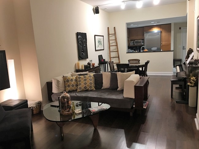
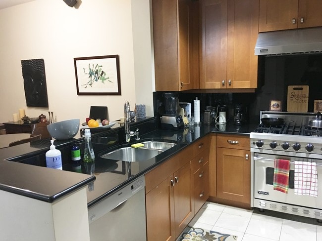
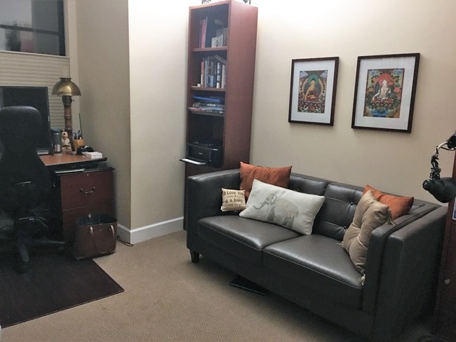
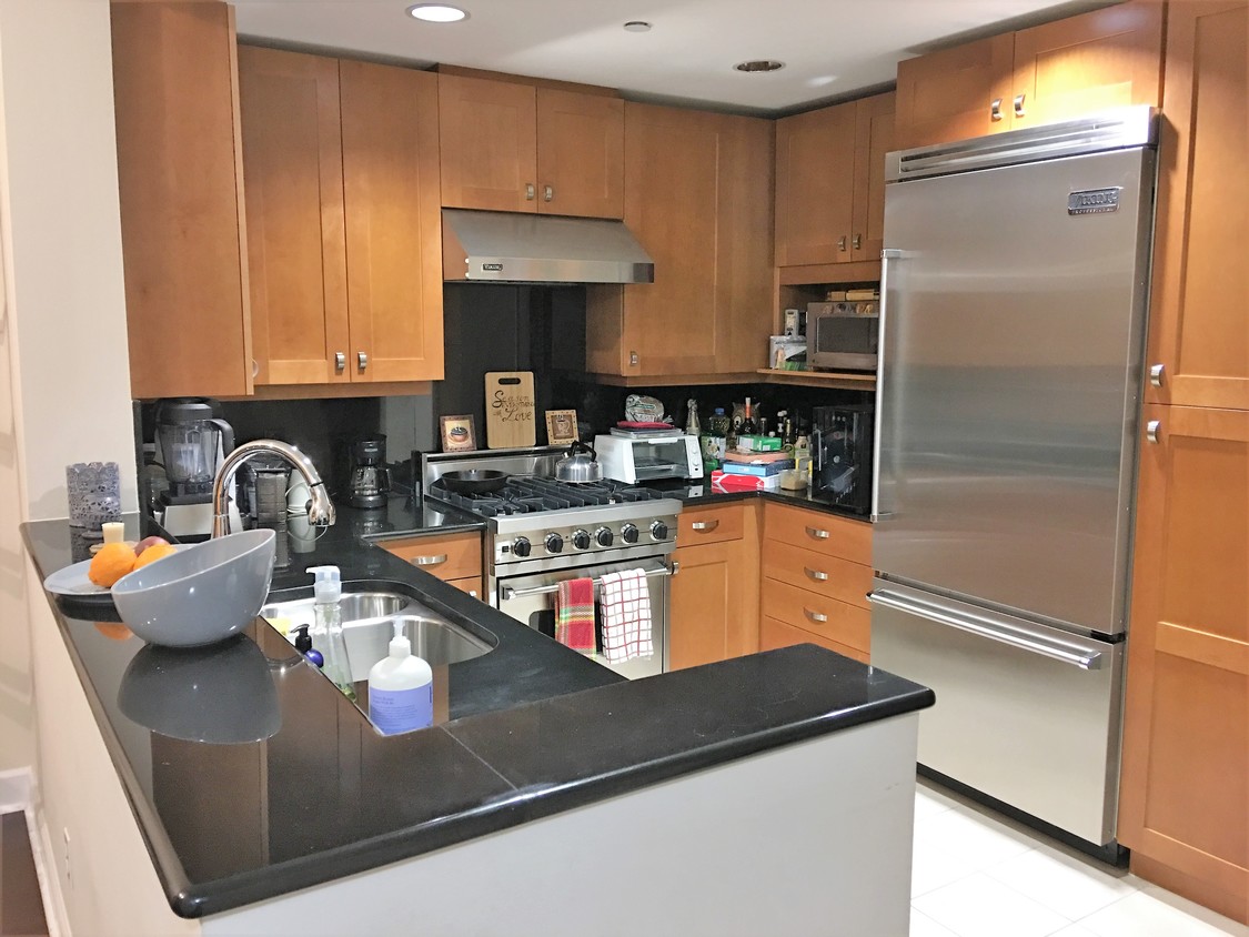
Prestigious 800 High Street Condominiums. *Stunning 2 Bedrooms, 2 Baths, 1,300 square feet. *Central heating and air conditioning *Newer & built in 2006 *Highly upgraded throughout. *One level, first floor location with patio. *Granite kitchen, *Viking stainless steel appliances including refrigerator. *Washer and Dryer. *Limestone and natural stone throughout. *Great location!! *1 Block to Whole Foods. *Conveniently located and just a few blocks to Cal Train and the coveted University Avenue.* Easy to show by appointment only. Excellent credit a must.
800 High St is a condo located in Santa Clara County and the 94301 ZIP Code. This area is served by the Palo Alto Unified School District attendance zone.
Condo Features
Washer/Dryer
Air Conditioning
Refrigerator
Stainless Steel Appliances
- Washer/Dryer
- Air Conditioning
- Stainless Steel Appliances
- Kitchen
- Refrigerator
- Patio
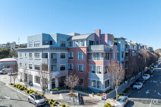
800 High Street
60 Units
4 Stories
Built in 2006
76,200 Sq Ft
800 High Street stands as a contemporary residential landmark in the vibrant University South neighborhood of Palo Alto. Completed in 2006, this four-story condominium complex houses 60 units, offering residents a prime location just steps from the bustling downtown area. The building's design seamlessly blends modern aesthetics with the charm of its surroundings, providing a comfortable and convenient living experience for those seeking an urban lifestyle in Silicon Valley's academic and technological hub.
Learn more about 800 High Street
800 High St,
Palo Alto,
CA
94301
Living in Palo Alto places you in Silicon Valley, where historic neighborhoods complement the city's technological presence. Tree-lined streets wind through the community, which is anchored by Stanford University. University Avenue features local boutiques and restaurants housed in preserved historic buildings, while the Stanford Shopping Center offers high-end retail destinations. The city maintains 36 parks and preserves, including the Baylands Nature Preserve and Foothills Park, where residents enjoy hiking trails and outdoor activities. Palo Alto's infrastructure supports alternative transportation, with dedicated bike lanes throughout the city.
The rental market in Palo Alto reflects the area's popularity, with current average rents ranging from $2,634 for studios to $6,139 for four-bedroom homes. Recent trends show steady growth, with rent increases varying from 1.8% to 17% across different unit sizes over the past year.
Learn more about living in Palo Alto
Amenities
- Washer/Dryer
- Air Conditioning
- Stainless Steel Appliances
- Kitchen
- Refrigerator
- Patio
Education
| Colleges & Universities | Distance | ||
|---|---|---|---|
| Colleges & Universities | Distance | ||
| Drive: | 7 min | 2.2 mi | |
| Drive: | 8 min | 2.8 mi | |
| Drive: | 11 min | 4.0 mi | |
| Drive: | 17 min | 8.1 mi |
800 High St Unit 114 is within 7 minutes or 2.2 miles from Stanford University. It is also near Menlo College and Foothill College, Middlefield.
Schools


Public Elementary School
Grades K-5
407 Students
Nearby
Public Elementary School
Grades K-5
366 Students
Attendance Zone
Public Middle School
Grades 6-8
732 Students
Attendance Zone
Public High School
Grades 9-12
1,891 Students
Attendance Zone
Private Elementary & Middle School
Grades PK-8
26,250 Students
Nearby
Private Middle & High School
Grades 6-12
422 Students
Nearby
School data provided by
 The GreatSchools Rating helps parents compare schools within a state based on a variety of school quality indicators and provides a helpful picture of how effectively each school serves all of its students. Ratings are on a scale of 1 (below average) to 10 (above average) and can include test scores, college readiness, academic progress, advanced courses, equity, discipline and attendance data. We also advise parents to visit schools, consider other information on school performance and programs, and consider family needs as part of the school selection process.
View GreatSchools Rating Methodology
Data provided by GreatSchools.org © 2026. All rights reserved.
View GreatSchools Rating Methodology
Data provided by GreatSchools.org © 2026. All rights reserved.
Transportation options available in Palo Alto include Mountain View Station, located 5.6 miles from 800 High St Unit 114. 800 High St Unit 114 is near Norman Y Mineta San Jose International, located 15.2 miles or 24 minutes away, and San Francisco International, located 20.9 miles or 30 minutes away.
| Transit / Subway | Distance | ||
|---|---|---|---|
| Transit / Subway | Distance | ||
| Drive: | 11 min | 5.6 mi | |
|
|
Drive: | 14 min | 6.9 mi |
| Drive: | 14 min | 7.6 mi | |
|
|
Drive: | 15 min | 8.2 mi |
| Drive: | 15 min | 8.5 mi |
| Commuter Rail | Distance | ||
|---|---|---|---|
| Commuter Rail | Distance | ||
| Walk: | 8 min | 0.4 mi | |
| Drive: | 5 min | 1.9 mi | |
| Drive: | 5 min | 2.0 mi | |
| Drive: | 10 min | 4.2 mi | |
| Drive: | 14 min | 5.5 mi |
| Airports | Distance | ||
|---|---|---|---|
| Airports | Distance | ||
|
Norman Y Mineta San Jose International
|
Drive: | 24 min | 15.2 mi |
|
San Francisco International
|
Drive: | 30 min | 20.9 mi |
Walkability Near 800 High St Palo Alto, CA 94301
Getting Around
 What do Walkability, Transit, Drivability, and Bikeability mean?
Walkability measures the walking distance to day-to-day needs.
Transit measures access to public transportation.
Drivability measures congestion, parking availability, and access to major roads.
Bikeability measures the suitability for cycling.
How It Works
What do Walkability, Transit, Drivability, and Bikeability mean?
Walkability measures the walking distance to day-to-day needs.
Transit measures access to public transportation.
Drivability measures congestion, parking availability, and access to major roads.
Bikeability measures the suitability for cycling.
How It Works
Very Walkable
Walkability
80
/ 100
Good Public Transit
Transit
70
/ 100
Moderately Drivable
Drivability
60
/ 100
Exceptionally Bikeable
Bikeability
90
/ 100
Scores provided by
-
Soundscore™
-
/ 100
Traffic
-Airport
-Businesses
-Scores provided by
HowLoud What is a Sound Score Rating? A Sound Score Rating aggregates noise caused by vehicle traffic, airplane traffic and local sources. How It WorksTime and distance from 800 High St Unit 114.
| Shopping Centers | Distance | ||
|---|---|---|---|
| Shopping Centers | Distance | ||
| Walk: | 7 min | 0.4 mi | |
| Drive: | 4 min | 1.2 mi | |
| Drive: | 5 min | 1.5 mi |
800 High St Unit 114 has 3 shopping centers within 1.5 miles, which is about a 5-minute drive. The miles and minutes will be for the farthest away property.
| Parks and Recreation | Distance | ||
|---|---|---|---|
| Parks and Recreation | Distance | ||
|
Gamble Garden
|
Walk: | 13 min | 0.7 mi |
|
Junior Museum and Zoo
|
Drive: | 3 min | 1.2 mi |
|
Rinconada Park
|
Drive: | 4 min | 1.4 mi |
|
Hopkins Creekside Park
|
Drive: | 5 min | 1.6 mi |
|
El Palo Alto Park
|
Drive: | 7 min | 2.2 mi |
800 High St Unit 114 has 5 parks within 2.2 miles, including Gamble Garden, El Palo Alto Park, and Junior Museum and Zoo.
| Hospitals | Distance | ||
|---|---|---|---|
| Hospitals | Distance | ||
| Drive: | 5 min | 1.6 mi | |
| Drive: | 7 min | 2.2 mi | |
| Drive: | 13 min | 7.3 mi |
800 High St Unit 114 has 3 hospitals within 7.3 miles, the nearest is Lucile Salter Packard Children's Hospital at Stanford which is 1.6 miles away and a 5 minute drive.
| Military Bases | Distance | ||
|---|---|---|---|
| Military Bases | Distance | ||
| Drive: | 17 min | 8.1 mi | |
| Drive: | 55 min | 36.4 mi | |
| Drive: | 56 min | 36.6 mi |
800 High St Unit 114 has 3 military bases within 36.6 miles, the nearest is Ames Research Center which is 8.1 miles away and a 17 minute drive.
You May Also Like
Similar Rentals Nearby


What Are Walk Score®, Transit Score®, and Bike Score® Ratings?
Walk Score® measures the walkability of any address. Transit Score® measures access to public transit. Bike Score® measures the bikeability of any address.
What is a Sound Score Rating?
A Sound Score Rating aggregates noise caused by vehicle traffic, airplane traffic and local sources.
800 High St
Palo Alto, CA 94301