

$1,100
/ Month
7702 Tollbridge Ct
Florence, KY 41042
2 Weeks Ago
Favorites
7702 Tollbridge Ct

Favorites
Check Back Soon for Upcoming Availability
| Beds | Baths | Average SF |
|---|---|---|
| 3 Bedrooms 3 Bedrooms 3 Br | 1 Bath 1 Bath 1 Ba | 1,200 SF |
About This Property
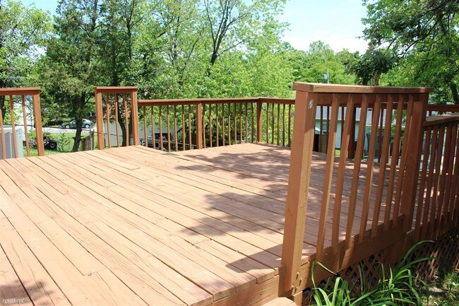
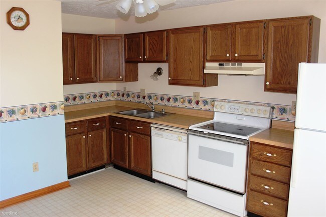
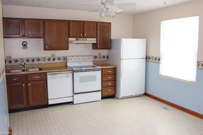
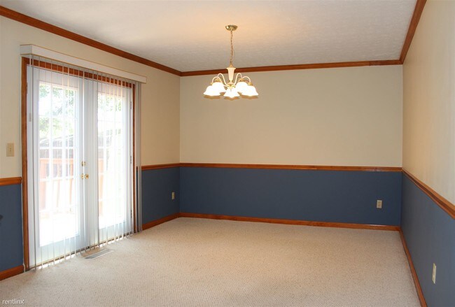
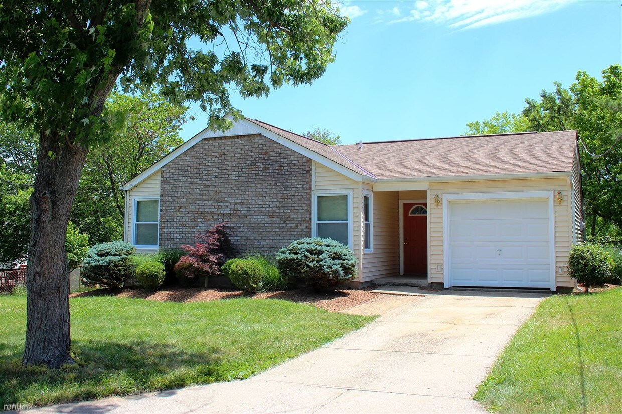
(513) 476-3969 - Spacious single story ranch with 3 bedrooms on a cul-de-sac. Covered front porch, large living room, eat-in kitchen, and large pantry. Additional room off the kitchen can be used as a dining room or family room with walk-out to large deck, great for entertaining. Oversized garage with built-in shelves for storage, plus shed in the back, and fenced yard. Freshly painted. Near 2 parks: Covered Bridge Park (0.1 mile) and Florence Nature Park (0.7 mile). Schools are Dixie Heights, Turkeyfoot Middle, and Caywood Elementary. Appliances included: refrigerator, smooth top range, oven, dishwasher, garbage disposal, washer, and dryer. Lease length: 12 months. Resident pays electric, water, sanitation, and trash. (RLNE2406616) Other Amenities - Parking, Garage- attached, Yard, Deck. Appliances - Dishwasher, Air Conditioning, Refrigerator, Range, Oven, Garbage Disposal, Washer & Dryer. Lease lengths - 12 Months. Details regarding this property's Utilities - Resident Pays Electricity, Resident Pays Water, Resident Pays Trash Pick-up. Pet policies - Small Dogs Allowed, Cats Allowed, Large Dogs Allowed.
7702 Tollbridge Ct is a house located in Boone County and the 41042 ZIP Code. This area is served by the Kenton County attendance zone.
House Features
- Air Conditioning
Location
Get Directions
Northern Kentucky is a sprawling region located just south of Cincinnati, Ohio. The Ohio River hugs the northern, eastern, and western portions of the region, serving as a scenic destination for all kinds of outdoor recreation throughout the year. Florence, Dayton, Newport, Covington, Burlington, and Highland Heights are among the many communities included in the Northern Kentucky region.
Each community in Northern Kentucky offers its own unique identity and sense of character. The rentals in the area are just as diverse as Northern Kentucky itself, ranging from luxury apartments to charming houses and everything in between. Getting around the region is a breeze with convenience to Interstates 71, 75, 275, and 471.
Learn more about living in Northern KentuckyBelow are rent ranges for similar nearby apartments
Amenities
- Air Conditioning
Education
| Colleges & Universities | Distance | ||
|---|---|---|---|
| Colleges & Universities | Distance | ||
| Drive: | 13 min | 4.8 mi | |
| Drive: | 22 min | 13.3 mi | |
| Drive: | 26 min | 16.1 mi | |
| Drive: | 34 min | 19.1 mi |
7702 Tollbridge Ct is within 13 minutes or 4.8 miles from Thomas More College. It is also near College of Mount St. Joseph and Northern Kentucky University.
Schools


Public Elementary School
Grades PK-5
544 Students
Attendance Zone
Public Middle School
Grades 6-8
1,029 Students
Attendance Zone
Public High School
Grades 9-12
1,279 Students
Nearby
Private Elementary & Middle School
Grades PK-8
273 Students
Nearby
Private Elementary, Middle & High School
Grades PK-12
139 Students
Nearby
School data provided by
 The GreatSchools Rating helps parents compare schools within a state based on a variety of school quality indicators and provides a helpful picture of how effectively each school serves all of its students. Ratings are on a scale of 1 (below average) to 10 (above average) and can include test scores, college readiness, academic progress, advanced courses, equity, discipline and attendance data. We also advise parents to visit schools, consider other information on school performance and programs, and consider family needs as part of the school selection process.
View GreatSchools Rating Methodology
Data provided by GreatSchools.org © 2025. All rights reserved.
View GreatSchools Rating Methodology
Data provided by GreatSchools.org © 2025. All rights reserved.
Transportation options available in Florence include The Banks Station, 2Nd & Main, located 12.0 miles from 7702 Tollbridge Ct. 7702 Tollbridge Ct is near Cincinnati/Northern Kentucky International, located 5.6 miles or 17 minutes away.
| Transit / Subway | Distance | ||
|---|---|---|---|
| Transit / Subway | Distance | ||
| Drive: | 20 min | 12.0 mi | |
| Drive: | 20 min | 12.1 mi | |
| Drive: | 20 min | 12.2 mi | |
| Drive: | 21 min | 12.3 mi | |
| Drive: | 21 min | 12.3 mi |
| Commuter Rail | Distance | ||
|---|---|---|---|
| Commuter Rail | Distance | ||
|
|
Drive: | 23 min | 13.0 mi |
| Airports | Distance | ||
|---|---|---|---|
| Airports | Distance | ||
|
Cincinnati/Northern Kentucky International
|
Drive: | 17 min | 5.6 mi |
Time and distance from 7702 Tollbridge Ct.
| Shopping Centers | Distance | ||
|---|---|---|---|
| Shopping Centers | Distance | ||
| Drive: | 4 min | 1.1 mi | |
| Drive: | 4 min | 1.2 mi | |
| Drive: | 5 min | 1.5 mi |
7702 Tollbridge Ct has 3 shopping centers within 1.5 miles, which is about a 5-minute drive. The miles and minutes will be for the farthest away property.
| Parks and Recreation | Distance | ||
|---|---|---|---|
| Parks and Recreation | Distance | ||
|
Boone County Arboretum
|
Drive: | 20 min | 10.7 mi |
|
John G. & Phyllis W. Smale Riverfront Park
|
Drive: | 20 min | 12.0 mi |
|
Wilson Commons
|
Drive: | 23 min | 14.2 mi |
|
Imago Earth Center
|
Drive: | 26 min | 15.4 mi |
|
Embshoff Woods
|
Drive: | 29 min | 16.9 mi |
7702 Tollbridge Ct has 5 parks within 16.9 miles, including Boone County Arboretum, John G. & Phyllis W. Smale Riverfront Park, and Embshoff Woods.
| Hospitals | Distance | ||
|---|---|---|---|
| Hospitals | Distance | ||
| Drive: | 6 min | 2.4 mi | |
| Drive: | 14 min | 5.8 mi | |
| Drive: | 13 min | 6.4 mi |
7702 Tollbridge Ct has 3 hospitals within 6.4 miles, the nearest is St. Elizabeth Florence which is 2.4 miles away and a 6 minute drive.
| Military Bases | Distance | ||
|---|---|---|---|
| Military Bases | Distance | ||
| Drive: | 89 min | 66.5 mi | |
| Drive: | 95 min | 71.6 mi | |
| Drive: | 97 min | 74.9 mi |
7702 Tollbridge Ct has 3 military bases within 74.9 miles, the nearest is Gentile Air Force Station which is 66.5 miles away and a 89 minute drive.
You May Also Like
Similar Rentals Nearby


What Are Walk Score®, Transit Score®, and Bike Score® Ratings?
Walk Score® measures the walkability of any address. Transit Score® measures access to public transit. Bike Score® measures the bikeability of any address.
What is a Sound Score Rating?
A Sound Score Rating aggregates noise caused by vehicle traffic, airplane traffic and local sources
7702 Tollbridge Ct
Florence, KY 41042