

$3,995 / Month
7405 Maywood Dr
Pleasanton, CA 94588
1 Day Ago
Favorites
-
Bedrooms
3
-
Bathrooms
2
-
Square Feet
1,488 sq ft
-
Available
Available Now
Highlights
- Forced Air Heating System
- Dining Room
7405 Maywood Dr

Favorites
About This Home
Available Now
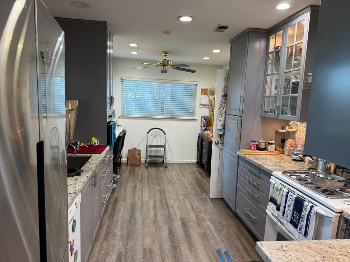
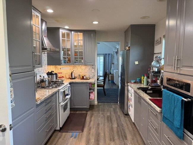
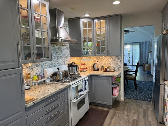
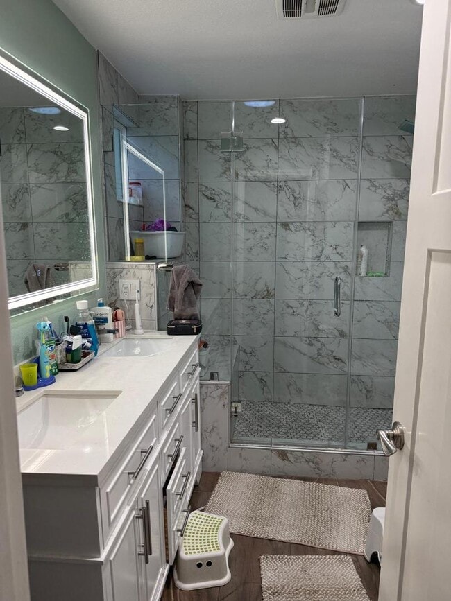
Completely remodeled 3 Bedroom and 2.5 Bath Stoneridge Townhome in a fantastic Pleasanton community with a beautiful and serene Greenbelt, Pool , Clubhouse and Tennis Courts. Recently updated throughout with new LVP flooring throughout the home, paint , light fixtures, remodeled bathrooms, remodeled kitchen with granite counters and stainless steel appliances. and more. Nestled in a fantastic location on West Side close to Stoneridge Mall, Bart, Foothill High School, Lydiksen Elementary and Muir wood Park one couldn't ask for a better move in ready home with views of the Pleasanton Ridge !
7405 Maywood Dr is a townhome located in Alameda County and the 94588 ZIP Code. This area is served by the Pleasanton Unified attendance zone.
* Price shown is base rent and may not include non-optional fees and utilities.
Price, availability, fees, and any applicable rent special are subject to change without notice.
* Square footage definitions vary. Displayed square footage is approximate.
Home Details
Home Type
Townhome
Bedrooms and Bathrooms
2 Full Bathrooms
3 Bedrooms
Interior Spaces
Living Room with Fireplace
Dining Room
1,488 Sq Ft Home
Listing and Financial Details
Security Deposit $3,995
Property Available on 7/7/25
12-Month Minimum Lease Term
Lot Details
2,662 Sq Ft Lot
Parking
2 Car Garage
Garage Door Opener
Utilities
Forced Air Heating System
Community Details
Fees and Policies
The fees below are based on community-supplied data and may exclude additional fees and utilities.
Contact
- Listed by Ramana Reddy | Calhomes
- Contact
-
Source
 MLSListings Inc.
Copyright © 2025 MLSListings Inc.
Location
Get Directions
Amenities
- Fireplace
The cities of Livermore, Dublin and Pleasanton form a loosely shaped triangle within California's Tri-Valley region, a cluster of three small valleys about 33 miles east of San Francisco and 35 miles northeast of San Jose. Known for its Mediterranean climate, rolling hills and historic vineyards, this once bucolic region now boasts three separate downtown areas, a bustling business community and some of the best wineries in the state.
At the eastern end of the region lies the city of Livermore. Once known as Livermores, Livermore Ranch and Nottingham, the city sits at the center of Livermore Valley, a historic region dotted with more than 5,000 acres of mostly family-owned vineyards. A pastoral neighborhood known for its charming yet functional hilltop windmills, Livermore hosts the internationally recognized and sometimes controversial center of scientific research, Lawrence Livermore National Laboratories.
Learn more about living in Dublin/Pleasanton/Livermore
Education
| Colleges & Universities | Distance | ||
|---|---|---|---|
| Colleges & Universities | Distance | ||
| Drive: | 13 min | 6.5 mi | |
| Drive: | 16 min | 9.5 mi | |
| Drive: | 22 min | 13.4 mi | |
| Drive: | 25 min | 15.0 mi |
7405 Maywood Dr is within 13 minutes or 6.5 miles from Diablo Valley Coll, San Ramon. It is also near Las Positas College and Cal State East Bay.
Schools


Public Elementary School
Grades K-5
604 Students
Attendance Zone
Public Elementary School
Grades K-5
497 Students
Nearby
Public Middle School
Grades 6-8
1,158 Students
Attendance Zone
Public High School
Grades 9-12
2,199 Students
Attendance Zone
Private Elementary School
Grades PK-1
106 Students
Nearby
Private Elementary School
Grades K-5
248 Students
Nearby
Private Middle & High School
Grades 6-12
Nearby
School data provided by
 The GreatSchools Rating helps parents compare schools within a state based on a variety of school quality indicators and provides a helpful picture of how effectively each school serves all of its students. Ratings are on a scale of 1 (below average) to 10 (above average) and can include test scores, college readiness, academic progress, advanced courses, equity, discipline and attendance data. We also advise parents to visit schools, consider other information on school performance and programs, and consider family needs as part of the school selection process.
View GreatSchools Rating Methodology
Data provided by GreatSchools.org © 2025. All rights reserved.
View GreatSchools Rating Methodology
Data provided by GreatSchools.org © 2025. All rights reserved.
Transportation options available in Pleasanton include West Dublin/Pleasanton Station, located 2.4 miles from 7405 Maywood Dr. 7405 Maywood Dr is near Metro Oakland International, located 19.7 miles or 27 minutes away, and Norman Y Mineta San Jose International, located 29.4 miles or 38 minutes away.
| Transit / Subway | Distance | ||
|---|---|---|---|
| Transit / Subway | Distance | ||
|
|
Drive: | 4 min | 2.4 mi |
|
|
Drive: | 5 min | 2.7 mi |
|
|
Drive: | 16 min | 11.3 mi |
|
|
Drive: | 25 min | 14.5 mi |
|
|
Drive: | 30 min | 18.8 mi |
| Commuter Rail | Distance | ||
|---|---|---|---|
| Commuter Rail | Distance | ||
| Drive: | 8 min | 4.6 mi | |
| Drive: | 8 min | 4.7 mi | |
| Drive: | 16 min | 10.9 mi | |
| Drive: | 17 min | 11.0 mi | |
|
|
Drive: | 19 min | 12.2 mi |
| Airports | Distance | ||
|---|---|---|---|
| Airports | Distance | ||
|
Metro Oakland International
|
Drive: | 27 min | 19.7 mi |
|
Norman Y Mineta San Jose International
|
Drive: | 38 min | 29.4 mi |
Time and distance from 7405 Maywood Dr.
| Shopping Centers | Distance | ||
|---|---|---|---|
| Shopping Centers | Distance | ||
| Drive: | 4 min | 1.1 mi | |
| Drive: | 4 min | 1.9 mi | |
| Drive: | 5 min | 2.3 mi |
7405 Maywood Dr has 3 shopping centers within 2.3 miles, which is about a 5-minute drive. The miles and minutes will be for the farthest away property.
| Parks and Recreation | Distance | ||
|---|---|---|---|
| Parks and Recreation | Distance | ||
|
Dublin Hills Regional Parks
|
Drive: | 14 min | 5.2 mi |
|
Shadow Cliffs Regional Recreation Area
|
Drive: | 14 min | 6.2 mi |
|
Bishop Ranch Regional Preserve
|
Drive: | 12 min | 7.8 mi |
|
Pleasanton Ridge Regional Park
|
Drive: | 17 min | 10.4 mi |
|
Garin/Dry Creek Pioneer Parks
|
Drive: | 30 min | 17.2 mi |
7405 Maywood Dr has 5 parks within 17.2 miles, including Dublin Hills Regional Parks, Pleasanton Ridge Regional Park, and Shadow Cliffs Regional Recreation Area.
| Hospitals | Distance | ||
|---|---|---|---|
| Hospitals | Distance | ||
| Drive: | 7 min | 3.3 mi | |
| Drive: | 13 min | 9.0 mi | |
| Drive: | 25 min | 17.2 mi |
7405 Maywood Dr has 3 hospitals within 17.2 miles, the nearest is Stanford Health Care - ValleyCare which is 3.3 miles away and a 7 minute drive.
| Military Bases | Distance | ||
|---|---|---|---|
| Military Bases | Distance | ||
| Drive: | 43 min | 32.2 mi |
7405 Maywood Dr is 32.2 miles and a 43 minute drive from Ames Research Center.
You May Also Like
Similar Rentals Nearby


What Are Walk Score®, Transit Score®, and Bike Score® Ratings?
Walk Score® measures the walkability of any address. Transit Score® measures access to public transit. Bike Score® measures the bikeability of any address.
What is a Sound Score Rating?
A Sound Score Rating aggregates noise caused by vehicle traffic, airplane traffic and local sources

7405 Maywood Dr
Pleasanton, CA 94588