


$1,595 / Month
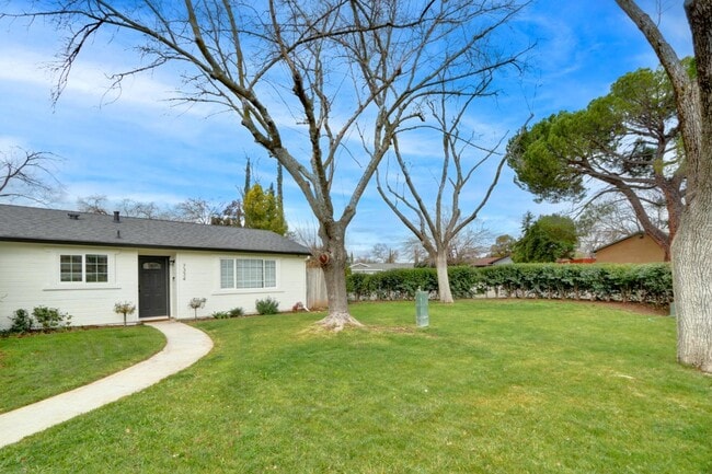
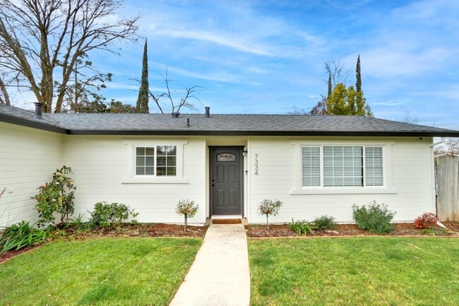
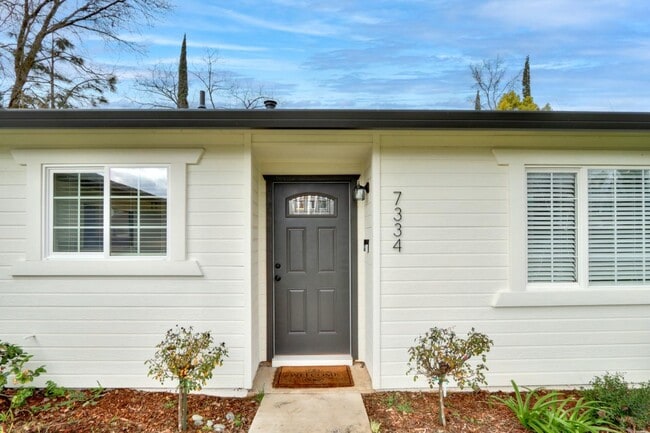
7334 Grenola Way
Citrus Heights, CA 95621
4 Days Ago
Favorites
-
Bedrooms
3
-
Bathrooms
2
-
Square Feet
1,162 sq ft
7334 Grenola Way

Favorites
About This Home
---- SCHEDULE A SHOWING ONLINE AT: ----
7334 Grenola Way is a condo located in Sacramento County and the 95621 ZIP Code.
* Price shown is base rent and may not include non-optional fees and utilities.
Price, availability, fees, and any applicable rent special are subject to change without notice.
* Square footage definitions vary. Displayed square footage is approximate.
Contact
- Listed by Locayt
Location
Get Directions
Defined by sun-drenched neighborhoods, tree-lined streets, and lacy palm trees against bright blue sky, Citrus Heights is a beautiful suburban city just 14 miles northeast of Downtown Sacramento. Citrus Heights residents enjoy easy access to I-80, for quick trips to Sacramento or northeast to Roseville, home of the Westfield Galleria at Roseville. Folsom Lake, a popular resort area, is minutes east of Citrus Heights.
Apartments in Citrus Heights provide a quieter option to city living while still being well within reach of everything this busy area has to offer -- including California State University, Sacramento, the Sacramento Zoo, and Sacramento International Airport. But as a busy city with plenty of businesses, shops, restaurants, and entertainment of its own, you'll find plenty to do closer to home. Go shopping at the Sunrise Mall, visit Rusch Park, home of the Historic Rusch Home and Gardens, and spend the afternoon golfing at Foothill Golf Center.
Learn more about living in Citrus Heights
Education
| Colleges & Universities | Distance | ||
|---|---|---|---|
| Colleges & Universities | Distance | ||
| Drive: | 12 min | 4.8 mi | |
| Drive: | 15 min | 9.7 mi | |
| Drive: | 27 min | 12.7 mi | |
| Drive: | 24 min | 15.2 mi |
7334 Grenola Way is within 12 minutes or 4.8 miles from American River College. It is also near Sierra College, Rocklin Campus and Folsom Lake College, Folsom.
Transportation options available in Citrus Heights include Watt/I-80, located 7.6 miles from 7334 Grenola Way. 7334 Grenola Way is near Sacramento International, located 22.7 miles or 32 minutes away.
| Transit / Subway | Distance | ||
|---|---|---|---|
| Transit / Subway | Distance | ||
|
|
Drive: | 11 min | 7.6 mi |
|
|
Drive: | 16 min | 8.7 mi |
|
|
Drive: | 13 min | 8.9 mi |
| Drive: | 13 min | 9.4 mi | |
|
|
Drive: | 17 min | 9.8 mi |
| Commuter Rail | Distance | ||
|---|---|---|---|
| Commuter Rail | Distance | ||
|
|
Drive: | 13 min | 6.6 mi |
|
|
Drive: | 14 min | 8.8 mi |
| Drive: | 21 min | 16.1 mi | |
| Drive: | 27 min | 21.0 mi | |
|
|
Drive: | 27 min | 21.1 mi |
| Airports | Distance | ||
|---|---|---|---|
| Airports | Distance | ||
|
Sacramento International
|
Drive: | 32 min | 22.7 mi |
Time and distance from 7334 Grenola Way.
| Shopping Centers | Distance | ||
|---|---|---|---|
| Shopping Centers | Distance | ||
| Walk: | 15 min | 0.8 mi | |
| Drive: | 3 min | 1.1 mi | |
| Drive: | 3 min | 1.2 mi |
7334 Grenola Way has 3 shopping centers within 1.2 miles, which is about a 3-minute walk. The miles and minutes will be for the farthest away property.
| Parks and Recreation | Distance | ||
|---|---|---|---|
| Parks and Recreation | Distance | ||
|
Jensen Botanical Gardens
|
Drive: | 11 min | 5.9 mi |
|
Aerospace Museum of California
|
Drive: | 14 min | 6.9 mi |
|
Mahany Park
|
Drive: | 17 min | 7.7 mi |
|
Lower Sunrise Recreational Area
|
Drive: | 16 min | 7.9 mi |
|
Sailor Bar County Park
|
Drive: | 17 min | 8.3 mi |
7334 Grenola Way has 5 parks within 8.3 miles, including Jensen Botanical Gardens, Aerospace Museum of California, and Lower Sunrise Recreational Area.
| Hospitals | Distance | ||
|---|---|---|---|
| Hospitals | Distance | ||
| Drive: | 6 min | 2.7 mi | |
| Drive: | 11 min | 5.4 mi | |
| Drive: | 11 min | 6.9 mi |
7334 Grenola Way has 3 hospitals within 6.9 miles, the nearest is Mercy San Juan Medical Center which is 2.7 miles away and a 6 minute drive.
| Military Bases | Distance | ||
|---|---|---|---|
| Military Bases | Distance | ||
| Drive: | 22 min | 8.8 mi |
7334 Grenola Way is 8.8 miles and a 22 minute drive from McClellan Air Force Base.
You May Also Like
Similar Rentals Nearby
-
-

-

-

-
 $2,5003 Beds, 2 Baths, 1,164 sq ftApartment for Rent
 -

-

-

-

-
 $3,2003 Beds, 2.5 Baths, 1,761 sq ftCondo for Rent
What Are Walk Score®, Transit Score®, and Bike Score® Ratings?
Walk Score® measures the walkability of any address. Transit Score® measures access to public transit. Bike Score® measures the bikeability of any address.
What is a Sound Score Rating?
A Sound Score Rating aggregates noise caused by vehicle traffic, airplane traffic and local sources
7334 Grenola Way
Citrus Heights, CA 95621