
$1,286 / Month
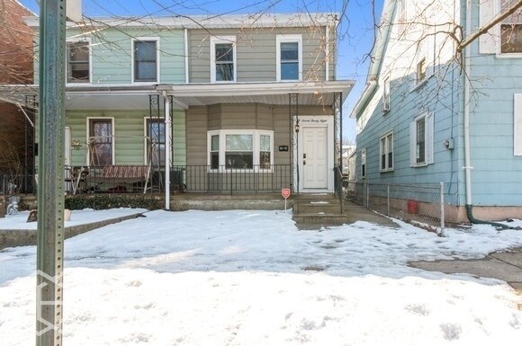
728 Powell St
Gloucester City, NJ 08030
2 Weeks Ago
Favorites
728 Powell St

Favorites
Check Back Soon for Upcoming Availability
| Beds | Baths | Average SF |
|---|---|---|
| 3 Bedrooms 3 Bedrooms 3 Br | 1 Bath 1 Bath 1 Ba | 1,407 SF |
Fees and Policies
The fees below are based on community-supplied data and may exclude additional fees and utilities.
- Dogs Allowed
-
Fees not specified
- Cats Allowed
-
Fees not specified
About This Property
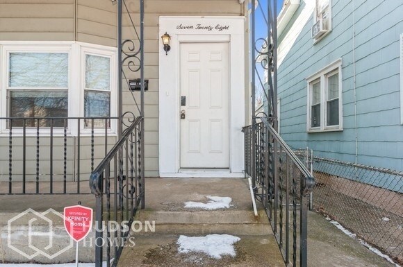
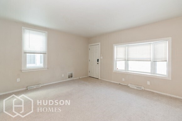
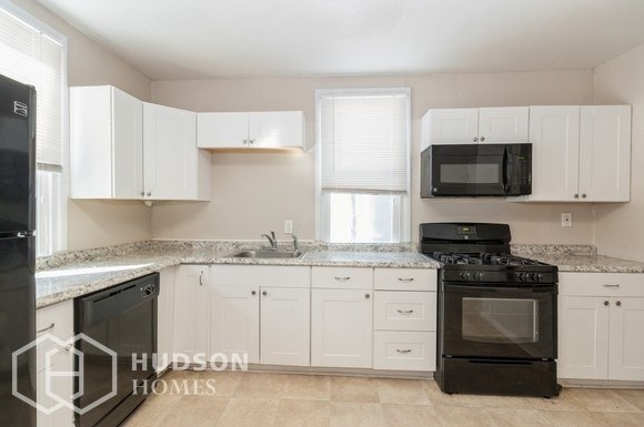
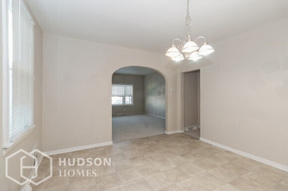
NOW AVAILABLE! Exclusively listed by Hudson Homes Management. Hurry, this home will not last long! Apply TODAY! Featuring 3 bedrooms, 1 bath, and 1,407 sqft! This home offers street access, a front porch, a large living area w/ a bay window, black kitchen appliances, a dining area, natural light, a fenced backyard, and much more! Schedule your convenient self-tour today! For FAQ's, visit https://www.hudsonhomesmanagement.com/faqs.aspx Prospective tenants to verify all information within this listing including, but not limited to, Bedrooms, Bathrooms, and Square Footage. Avoid Rental Scams: Hudson Homes Management does not advertise on Craigslist and will never ask you to wire money or request funds through a payment app on your mobile device. CONSENT TO TEXT MESSAGING: By entering your mobile phone number, you expressly consent to receive text messages from Hudson Homes Management. Msg & Data rates may apply. This property allows self guided viewing without an appointment. Contact for details.
728 Powell St is a house located in Camden County and the 08030 ZIP Code. This area is served by the Gloucester City Public attendance zone.
Location
Get Directions
Located just across the Delaware River from Philadelphia and the Port of Philadelphia, Gloucester City is a predominantly residential area in Camden County. Gloucester City is home to numerous parks, such as Proprietors Park and Johnson Park, which offer plenty of opportunities to engage in outdoor recreation.
Gloucester City is just minutes from shopping destinations like Deptford Mall and Cherry Hill Mall. Sports fans delight in Gloucester City’s close proximity to Lincoln Financial Field and Citizens Bank Park, where home games for the Eagles and the Phillies take place, respectively. Easy access to the Walt Whitman Bridge, Philadelphia International Airport, and Interstates 76, 676, and 295 makes getting around from Gloucester City simple.
Learn more about living in Gloucester City
Education
| Colleges & Universities | Distance | ||
|---|---|---|---|
| Colleges & Universities | Distance | ||
| Drive: | 7 min | 3.9 mi | |
| Drive: | 8 min | 4.3 mi | |
| Drive: | 13 min | 7.2 mi | |
| Drive: | 13 min | 7.8 mi |
728 Powell St is within 7 minutes or 3.9 miles from Camden Co. Coll., Camden City. It is also near Rutgers, Camden Campus and Thomas Jefferson University.
Schools


Public Elementary School
Grades PK-3
842 Students
Attendance Zone
Public Elementary School
Grades 4-6
439 Students
Attendance Zone
Public High School
Grades 9-12
702 Students
Attendance Zone
Private Elementary & Middle School
Grades PK-8
Nearby
Private Middle & High School
Grades 7-12
510 Students
Nearby
School data provided by
 The GreatSchools Rating helps parents compare schools within a state based on a variety of school quality indicators and provides a helpful picture of how effectively each school serves all of its students. Ratings are on a scale of 1 (below average) to 10 (above average) and can include test scores, college readiness, academic progress, advanced courses, equity, discipline and attendance data. We also advise parents to visit schools, consider other information on school performance and programs, and consider family needs as part of the school selection process.
View GreatSchools Rating Methodology
Data provided by GreatSchools.org © 2025. All rights reserved.
View GreatSchools Rating Methodology
Data provided by GreatSchools.org © 2025. All rights reserved.
Transportation options available in Gloucester City include Ferry Avenue, located 3.6 miles from 728 Powell St. 728 Powell St is near Philadelphia International, located 11.8 miles or 22 minutes away, and Trenton Mercer, located 39.3 miles or 56 minutes away.
| Transit / Subway | Distance | ||
|---|---|---|---|
| Transit / Subway | Distance | ||
|
|
Drive: | 8 min | 3.6 mi |
|
|
Drive: | 8 min | 3.8 mi |
|
|
Drive: | 8 min | 4.6 mi |
|
|
Drive: | 9 min | 5.5 mi |
|
|
Drive: | 10 min | 5.7 mi |
| Commuter Rail | Distance | ||
|---|---|---|---|
| Commuter Rail | Distance | ||
|
|
Drive: | 12 min | 7.1 mi |
|
|
Drive: | 12 min | 7.3 mi |
|
|
Drive: | 13 min | 7.6 mi |
|
|
Drive: | 15 min | 8.3 mi |
| Drive: | 14 min | 8.9 mi |
| Airports | Distance | ||
|---|---|---|---|
| Airports | Distance | ||
|
Philadelphia International
|
Drive: | 22 min | 11.8 mi |
|
Trenton Mercer
|
Drive: | 56 min | 39.3 mi |
Time and distance from 728 Powell St.
| Shopping Centers | Distance | ||
|---|---|---|---|
| Shopping Centers | Distance | ||
| Walk: | 6 min | 0.3 mi | |
| Walk: | 18 min | 0.9 mi | |
| Drive: | 3 min | 1.7 mi |
728 Powell St has 3 shopping centers within 1.7 miles, which is about a 3-minute walk. The miles and minutes will be for the farthest away property.
| Parks and Recreation | Distance | ||
|---|---|---|---|
| Parks and Recreation | Distance | ||
|
Camden Children's Garden
|
Drive: | 8 min | 4.2 mi |
|
Adventure Aquarium
|
Drive: | 9 min | 4.6 mi |
|
Franklin D. Roosevelt Park
|
Drive: | 14 min | 6.8 mi |
|
Gloria Dei Church National Historic Site
|
Drive: | 12 min | 6.9 mi |
|
Thaddeus Kosciuszko National Memorial
|
Drive: | 13 min | 7.2 mi |
728 Powell St has 5 parks within 7.2 miles, including Camden Children's Garden, Adventure Aquarium, and Thaddeus Kosciuszko National Memorial.
| Hospitals | Distance | ||
|---|---|---|---|
| Hospitals | Distance | ||
| Drive: | 7 min | 3.7 mi | |
| Drive: | 7 min | 3.9 mi | |
| Drive: | 7 min | 4.2 mi |
728 Powell St has 3 hospitals within 4.2 miles, the nearest is Cooper University Hospital which is 3.7 miles away and a 7 minute drive.
| Military Bases | Distance | ||
|---|---|---|---|
| Military Bases | Distance | ||
| Drive: | 13 min | 6.9 mi |
728 Powell St is 6.9 miles and a 13 minute drive from Philadelphia Naval Busi Center.
You May Also Like
Similar Rentals Nearby


What Are Walk Score®, Transit Score®, and Bike Score® Ratings?
Walk Score® measures the walkability of any address. Transit Score® measures access to public transit. Bike Score® measures the bikeability of any address.
What is a Sound Score Rating?
A Sound Score Rating aggregates noise caused by vehicle traffic, airplane traffic and local sources

728 Powell St
Gloucester City, NJ 08030