

$1,895
/ Month
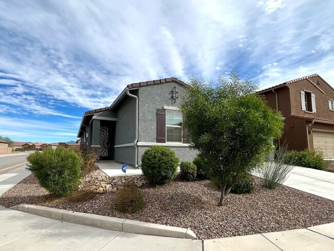
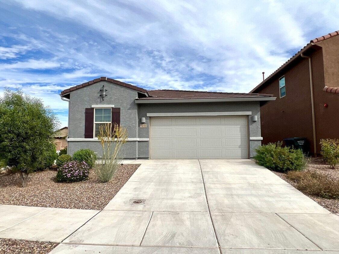
7251 S Camino del Cordero
Tucson, AZ 85756
Favorites
7251 S Camino del Cordero

Favorites
Check Back Soon for Upcoming Availability
| Beds | Baths | Average SF |
|---|---|---|
| 4 Bedrooms 4 Bedrooms 4 Br | 2 Baths 2 Baths 2 Ba | 1,912 SF |
About This Property
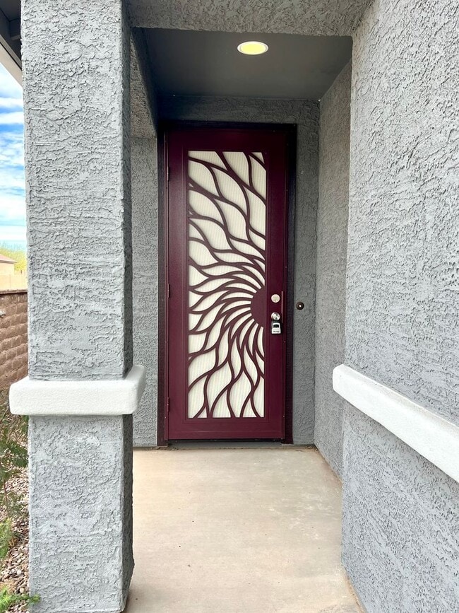
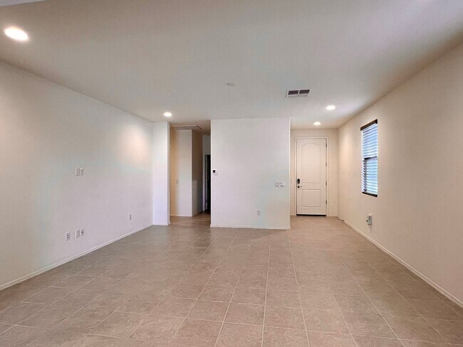
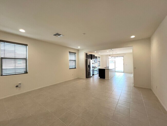
This beautifully upgraded 4 bedroom, 2 bathroom home is ready to move in. Featuring the large great room and inviting kitchen with granite countertops, plenty of cabinet space, large island bar, pantry and dining area. The home features 4 bedroom split floor, including a beautiful primary suite with walk-in shower and oversized walk-in closet. Mountain views can be seen for the large backyard complete with artificial turf and paver brick patio. Community offers the Award Winning Vail School District, numerous parks and community pool. Good credit, background and income required. All pets must be preapproved by owner with extra deposit and rent.
7251 S Camino Del Cordero is a house located in Pima County and the 85756 ZIP Code. This area is served by the Vail Unified District attendance zone.
7251 S Camino del Cordero,
Tucson,
AZ
85756
In the city of Tucson, Ward 4 sits east of Interstate 19, with Interstate 10 running north and south through its east side. Ward 4 consists of several neighborhoods including Dietz, Groves Lincoln Park, Terra Del Sol, Civano, and Mesquite Ranch. Pima County’s Ward 4 has a variety of rentals, many of which reflect southwestern styles. Residents head to the town’s recreation center several times a week for freshly brewed coffee and potluck dinners.
Neighbors use the Valencia Library computers, meeting and study rooms, and Wi-Fi to study for exams or to read a book. Locals are sure to swing by Omar’s Hi-Way Chef Restaurant for a diner-style meal, such as fluffy pancakes, sausage, eggs, and country fried potatoes.
Learn more about living in Ward 4Below are rent ranges for similar nearby apartments
Education
| Colleges & Universities | Distance | ||
|---|---|---|---|
| Colleges & Universities | Distance | ||
| Drive: | 12 min | 6.4 mi | |
| Drive: | 19 min | 9.8 mi | |
| Drive: | 20 min | 12.1 mi | |
| Drive: | 17 min | 12.2 mi |
7251 S Camino del Cordero is within 12 minutes or 6.4 miles from Pima C.C., East Campus. It is also near Pima C.C., Desert Vista Campus and University of Arizona.
Schools


Public Elementary School
Grades K-5
563 Students
Attendance Zone
Public Elementary, Middle & High School
Grades K-12
61 Students
Attendance Zone
Public Middle School
Grades 6-8
739 Students
Attendance Zone
Public High School
Grades 9-12
836 Students
Attendance Zone
Public High School
Grades 9-12
886 Students
Attendance Zone
Private Elementary & Middle School
Grades PK-8
316 Students
Nearby
Private Elementary, Middle & High School
Grades K-12
61 Students
Nearby
School data provided by
 The GreatSchools Rating helps parents compare schools within a state based on a variety of school quality indicators and provides a helpful picture of how effectively each school serves all of its students. Ratings are on a scale of 1 (below average) to 10 (above average) and can include test scores, college readiness, academic progress, advanced courses, equity, discipline and attendance data. We also advise parents to visit schools, consider other information on school performance and programs, and consider family needs as part of the school selection process.
View GreatSchools Rating Methodology
Data provided by GreatSchools.org © 2026. All rights reserved.
View GreatSchools Rating Methodology
Data provided by GreatSchools.org © 2026. All rights reserved.
Transportation options available in Tucson include Sl/2Nd St/Cherry Av, located 11.7 miles from 7251 S Camino del Cordero. 7251 S Camino del Cordero is near Tucson International, located 6.8 miles or 13 minutes away.
| Transit / Subway | Distance | ||
|---|---|---|---|
| Transit / Subway | Distance | ||
| Drive: | 19 min | 11.7 mi | |
| Drive: | 20 min | 11.8 mi | |
| Drive: | 16 min | 12.2 mi | |
| Drive: | 16 min | 12.4 mi | |
| Drive: | 17 min | 12.6 mi |
| Commuter Rail | Distance | ||
|---|---|---|---|
| Commuter Rail | Distance | ||
|
|
Drive: | 17 min | 12.5 mi |
|
|
Drive: | 40 min | 36.7 mi |
| Airports | Distance | ||
|---|---|---|---|
| Airports | Distance | ||
|
Tucson International
|
Drive: | 13 min | 6.8 mi |
Walkability Near 7251 S Camino del Cordero Tucson, AZ 85756
Getting Around
 What do Walkability, Transit, Drivability, and Bikeability mean?
Walkability measures the walking distance to day-to-day needs.
Transit measures access to public transportation.
Drivability measures congestion, parking availability, and access to major roads.
Bikeability measures the suitability for cycling.
How It Works
What do Walkability, Transit, Drivability, and Bikeability mean?
Walkability measures the walking distance to day-to-day needs.
Transit measures access to public transportation.
Drivability measures congestion, parking availability, and access to major roads.
Bikeability measures the suitability for cycling.
How It Works
Not Walkable
Walkability
10
/ 100
Minimal Public Transit
Transit
0
/ 100
Exceptionally Drivable
Drivability
100
/ 100
Fairly Bikeable
Bikeability
50
/ 100
Scores provided by
-
Soundscore™
-
/ 100
Traffic
-Airport
-Businesses
-Scores provided by
HowLoud What is a Sound Score Rating? A Sound Score Rating aggregates noise caused by vehicle traffic, airplane traffic and local sources. How It WorksTime and distance from 7251 S Camino del Cordero.
| Shopping Centers | Distance | ||
|---|---|---|---|
| Shopping Centers | Distance | ||
| Drive: | 5 min | 2.8 mi | |
| Drive: | 7 min | 4.9 mi | |
| Drive: | 10 min | 5.9 mi |
7251 S Camino del Cordero has 3 shopping centers within 5.9 miles, which is about a 10-minute drive. The miles and minutes will be for the farthest away property.
| Parks and Recreation | Distance | ||
|---|---|---|---|
| Parks and Recreation | Distance | ||
|
Thomas Jay Regional Park
|
Drive: | 5 min | 2.7 mi |
|
Augie Acuna Los Ninos Park
|
Drive: | 10 min | 4.9 mi |
|
Groves Park
|
Drive: | 12 min | 5.8 mi |
|
Escalante Park
|
Drive: | 11 min | 6.1 mi |
|
Abraham Lincoln Park and Atturbury Wash Greenway
|
Drive: | 12 min | 6.5 mi |
7251 S Camino del Cordero has 5 parks within 6.5 miles, including Thomas Jay Regional Park, Augie Acuna Los Ninos Park, and Groves Park.
| Hospitals | Distance | ||
|---|---|---|---|
| Hospitals | Distance | ||
| Drive: | 11 min | 7.9 mi | |
| Drive: | 17 min | 9.9 mi | |
| Drive: | 19 min | 10.9 mi |
7251 S Camino del Cordero has 3 hospitals within 10.9 miles, the nearest is Banner - University Medical Center South Campus which is 7.9 miles away and a 11 minute drive.
| Military Bases | Distance | ||
|---|---|---|---|
| Military Bases | Distance | ||
| Drive: | 8 min | 5.0 mi | |
| Drive: | 14 min | 6.9 mi | |
| Drive: | 74 min | 63.4 mi |
7251 S Camino del Cordero has 3 military bases within 63.4 miles, the nearest is Davis Monthan Air Force Base which is 5.0 miles away and a 8 minute drive.
You May Also Like
Similar Rentals Nearby
-
-

-

-
 4 Beds$2,160Total Monthly PriceTotal Monthly Price NewPrices include all required monthly fees.House for Rent
 -
 4 Beds$2,020Total Monthly PriceTotal Monthly Price NewPrices include all required monthly fees.House for Rent
 -
 4 Beds$2,245Total Monthly PriceTotal Monthly Price NewPrices include all required monthly fees.House for Rent
 -
 4 Beds$2,145Total Monthly PriceTotal Monthly Price NewPrices include all required monthly fees.House for Rent
 -
 4 Beds$2,075Total Monthly PriceTotal Monthly Price NewPrices include all required monthly fees.House for Rent
 -
 4 Beds$1,920Total Monthly PriceTotal Monthly Price NewPrices include all required monthly fees.House for Rent
 -
 4 Beds$1,940Total Monthly PriceTotal Monthly Price NewPrices include all required monthly fees.House for Rent
What Are Walk Score®, Transit Score®, and Bike Score® Ratings?
Walk Score® measures the walkability of any address. Transit Score® measures access to public transit. Bike Score® measures the bikeability of any address.
What is a Sound Score Rating?
A Sound Score Rating aggregates noise caused by vehicle traffic, airplane traffic and local sources.
7251 S Camino del Cordero
Tucson, AZ 85756