
$3,800 / Month
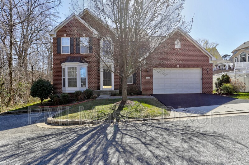
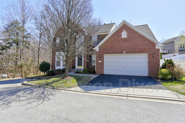
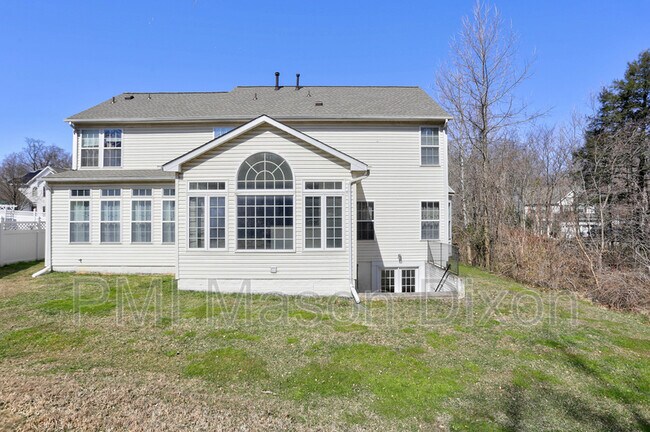
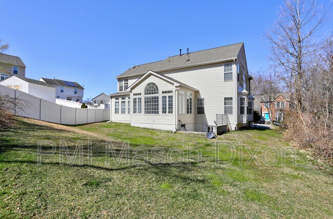
7232 Lyndsey Way
Elkridge, MD 21075
2 Weeks Ago
Favorites
7232 Lyndsey Way

Favorites
Check Back Soon for Upcoming Availability
| Beds | Baths | Average SF |
|---|---|---|
| 4 Bedrooms 4 Bedrooms 4 Br | 3.5 Baths 3.5 Baths 3.5 Ba | 2,668 SF |
About This Property
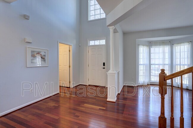
Stunning 4BD, 3.5BA, brick, single-family home in Elkridge, boasts a beautiful sun-lit/eat-in kitchen. Spacious bedrooms with natural light. Large finished basement, with extra bedrooms and a two-car garage. Pets Welcome. Available April 1st. Verifiable income and a 640 credit score are required of all adults. Every applicant over 18yrs must fill out a tenant application ($60 application fee pp).
7232 Lyndsey Way is a house located in Howard County and the 21075 ZIP Code. This area is served by the Howard County Public Schools attendance zone.
Location
Get Directions
Jessup-Howard is a sprawling neighborhood located 15 miles southeast of Baltimore. Jessup-Howard is a popular place as it’s home to retail centers, office spaces, and distribution centers between Washington Road and Dorsey Run Road. While the neighborhood is full of popular amenities, large natural areas like Patuxent Research Refuge, exciting attractions like Live! Casino and Hotel, and the Baltimore/Washington International Thurgood Marshall Airport can be found outside of town. Family-friendly fun is available close to home at places like Autobahn Indoor Speedway and Events and Guilford Park, and residents enjoy fishing and hiking along the streams and ponds throughout town. Despite being mostly commercial, Jessup-Howard has multiple choices of modern apartments located along the borders of town.
Learn more about living in Jessup-HowardBelow are rent ranges for similar nearby apartments
Education
| Colleges & Universities | Distance | ||
|---|---|---|---|
| Colleges & Universities | Distance | ||
| Drive: | 14 min | 8.1 mi | |
| Drive: | 14 min | 8.6 mi | |
| Drive: | 18 min | 9.9 mi | |
| Drive: | 20 min | 12.6 mi |
7232 Lyndsey Way is within 14 minutes or 8.1 miles from UMBC. It is also near CCBC Cantonsville and Howard Community College.
Schools


Public Elementary School
Grades PK-5
723 Students
Nearby
Public Elementary School
Grades PK-5
617 Students
Nearby
Public Middle School
Grades 6-8
858 Students
Attendance Zone
Public High School
Grades 9-12
1,401 Students
Attendance Zone
Private Elementary, Middle & High School
Grades PK-12
Nearby
Private Elementary, Middle & High School
Grades 1-12
Nearby
Private Elementary School
Grades K-3
37 Students
Nearby
School data provided by
 The GreatSchools Rating helps parents compare schools within a state based on a variety of school quality indicators and provides a helpful picture of how effectively each school serves all of its students. Ratings are on a scale of 1 (below average) to 10 (above average) and can include test scores, college readiness, academic progress, advanced courses, equity, discipline and attendance data. We also advise parents to visit schools, consider other information on school performance and programs, and consider family needs as part of the school selection process.
View GreatSchools Rating Methodology
Data provided by GreatSchools.org © 2025. All rights reserved.
View GreatSchools Rating Methodology
Data provided by GreatSchools.org © 2025. All rights reserved.
Transportation options available in Elkridge include Dorsey, located 1.8 miles from 7232 Lyndsey Way. 7232 Lyndsey Way is near Baltimore/Washington International Thurgood Marshall, located 8.1 miles or 15 minutes away, and Ronald Reagan Washington Ntl, located 34.3 miles or 52 minutes away.
| Transit / Subway | Distance | ||
|---|---|---|---|
| Transit / Subway | Distance | ||
|
|
Drive: | 4 min | 1.8 mi |
|
|
Drive: | 15 min | 8.2 mi |
|
|
Drive: | 16 min | 8.4 mi |
|
|
Drive: | 17 min | 10.3 mi |
|
|
Drive: | 18 min | 11.5 mi |
| Commuter Rail | Distance | ||
|---|---|---|---|
| Commuter Rail | Distance | ||
| Drive: | 4 min | 1.9 mi | |
| Drive: | 4 min | 1.9 mi | |
|
|
Drive: | 7 min | 2.9 mi |
| Drive: | 10 min | 5.2 mi | |
|
|
Drive: | 15 min | 8.2 mi |
| Airports | Distance | ||
|---|---|---|---|
| Airports | Distance | ||
|
Baltimore/Washington International Thurgood Marshall
|
Drive: | 15 min | 8.1 mi |
|
Ronald Reagan Washington Ntl
|
Drive: | 52 min | 34.3 mi |
Time and distance from 7232 Lyndsey Way.
| Shopping Centers | Distance | ||
|---|---|---|---|
| Shopping Centers | Distance | ||
| Walk: | 16 min | 0.9 mi | |
| Drive: | 3 min | 1.5 mi | |
| Drive: | 4 min | 2.0 mi |
7232 Lyndsey Way has 3 shopping centers within 2.0 miles, which is about a 4-minute walk. The miles and minutes will be for the farthest away property.
| Parks and Recreation | Distance | ||
|---|---|---|---|
| Parks and Recreation | Distance | ||
|
Banneker Planetarium
|
Drive: | 14 min | 8.6 mi |
|
Benjamin Banneker Historical Park and Museum
|
Drive: | 20 min | 9.1 mi |
|
Patuxent Research Refuge - North Tract
|
Drive: | 20 min | 10.1 mi |
|
Clark's Elioak Farm
|
Drive: | 16 min | 10.3 mi |
|
Carroll Park
|
Drive: | 17 min | 11.0 mi |
7232 Lyndsey Way has 5 parks within 11.0 miles, including Banneker Planetarium, Benjamin Banneker Historical Park and Museum, and Clark's Elioak Farm.
| Hospitals | Distance | ||
|---|---|---|---|
| Hospitals | Distance | ||
| Drive: | 18 min | 10.0 mi | |
| Drive: | 18 min | 10.2 mi | |
| Drive: | 16 min | 10.3 mi |
7232 Lyndsey Way has 3 hospitals within 10.3 miles, the nearest is Howard County General Hospital which is 10.0 miles away and a 18 minute drive.
| Military Bases | Distance | ||
|---|---|---|---|
| Military Bases | Distance | ||
| Drive: | 18 min | 8.5 mi |
7232 Lyndsey Way is 8.5 miles and a 18 minute drive from Fort George Meade.
You May Also Like
Similar Rentals Nearby


What Are Walk Score®, Transit Score®, and Bike Score® Ratings?
Walk Score® measures the walkability of any address. Transit Score® measures access to public transit. Bike Score® measures the bikeability of any address.
What is a Sound Score Rating?
A Sound Score Rating aggregates noise caused by vehicle traffic, airplane traffic and local sources

7232 Lyndsey Way
Elkridge, MD 21075