

$1,995
/ Month
72 Orphanage Rd
Fort Mitchell, KY 41017
Favorites
72 Orphanage Rd

Favorites
Check Back Soon for Upcoming Availability
| Beds | Baths | Average SF |
|---|---|---|
| 2 Bedrooms 2 Bedrooms 2 Br | 1 Bath 1 Bath 1 Ba | 950 SF |
Fees and Policies
The fees listed below are community-provided and may exclude utilities or add-ons. All payments are made directly to the property and are non-refundable unless otherwise specified.
- Parking
-
Garage--
About This Property
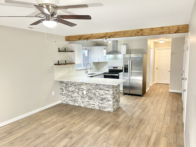
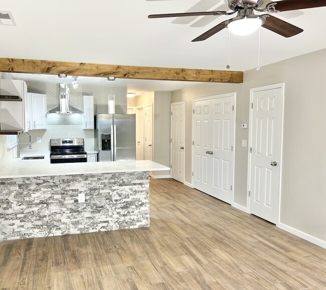
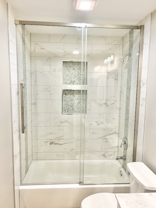
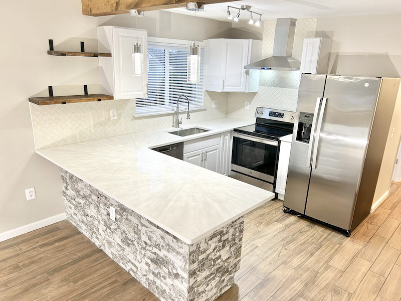
Move in ready with washer/dryer and garage parking. Brand new stainless steel appliances with ice maker and garbage disposal. Quartz countertops. High efficiency central air conditioning and heating. Large kitchen pantry, and linen closet. Brand new washer and dryer included. Garage parking with remote included. Additional storage space included. Pets welcomed. (No pet deposit required) 12-24 month leases available. Close to Covington, Mainstrasse, Downtown Cincinnati, Florence, Newport and CVG Video walkthrough available. Contact us to schedule a showing today! (8 5 9) 7 3 9 - 3 7 0 7 7
72 Orphanage Rd is a townhome located in Kenton County and the 41017 ZIP Code. This area is served by the Beechwood Independent attendance zone.
Townhome Features
Air Conditioning
Dishwasher
Refrigerator
Range
- Air Conditioning
- Dishwasher
- Range
- Refrigerator
- Laundry Facilities
- Storage Space
72 Orphanage Rd,
Fort Mitchell,
KY
41017
Located in northern Kentucky, just five miles southwest of Cincinnati, Fort Mitchell is consistently ranked among the best places to live in the state. Lush and laden with trees, Fort Mitchell exudes a small-town feel on the cusp of a big city. Community events draw residents together in Fort Mitchell, including a popular Annual Fourth of July Parade and frequent city-sponsored classes programs.
Fort Mitchell is home to the world’s only ventriloquist museum, the Vent Haven Museum, as well as three cemeteries. Suburban amenities are plentiful near Fort Mitchell, with easy access to the retail delights of the Crestview Hills Town Center and the many outdoor activities available at Devou Park. The numerous metropolitan amenities of Cincinnati are just a short drive away as well. Getting around from Fort Mitchell is a breeze with convenience to Interstates 71, 75, and 275 in addition to Cincinnati-Northern Kentucky International Airport.
Learn more about living in Fort Mitchell
Amenities
- Air Conditioning
- Dishwasher
- Range
- Refrigerator
- Laundry Facilities
- Storage Space
Education
| Colleges & Universities | Distance | ||
|---|---|---|---|
| Colleges & Universities | Distance | ||
| Drive: | 5 min | 2.2 mi | |
| Drive: | 13 min | 7.7 mi | |
| Drive: | 17 min | 10.4 mi | |
| Drive: | 24 min | 13.5 mi |
72 Orphanage Rd is within 5 minutes or 2.2 miles from Thomas More College. It is also near Northern Kentucky University and College of Mount St. Joseph.
Schools


Public Elementary School
Grades PK-5
776 Students
Attendance Zone
Public Middle & High School
Grades 6-12
758 Students
Attendance Zone
Private Elementary School
Grades PK-5
95 Students
Nearby
Private Elementary, Middle & High School
Grades K-12
Nearby
Private Elementary & Middle School
Grades K-8
496 Students
Nearby
Private Elementary School
Grades K-5
Nearby
School data provided by
 The GreatSchools Rating helps parents compare schools within a state based on a variety of school quality indicators and provides a helpful picture of how effectively each school serves all of its students. Ratings are on a scale of 1 (below average) to 10 (above average) and can include test scores, college readiness, academic progress, advanced courses, equity, discipline and attendance data. We also advise parents to visit schools, consider other information on school performance and programs, and consider family needs as part of the school selection process.
View GreatSchools Rating Methodology
Data provided by GreatSchools.org © 2026. All rights reserved.
View GreatSchools Rating Methodology
Data provided by GreatSchools.org © 2026. All rights reserved.
Transportation options available in Fort Mitchell include The Banks Station - 2Nd & Main, located 6.3 miles from 72 Orphanage Rd. 72 Orphanage Rd is near Cincinnati/Northern Kentucky International, located 7.7 miles or 19 minutes away.
| Transit / Subway | Distance | ||
|---|---|---|---|
| Transit / Subway | Distance | ||
| Drive: | 11 min | 6.3 mi | |
| Drive: | 11 min | 6.4 mi | |
| Drive: | 11 min | 6.5 mi | |
| Drive: | 12 min | 6.6 mi | |
| Drive: | 12 min | 6.7 mi |
| Commuter Rail | Distance | ||
|---|---|---|---|
| Commuter Rail | Distance | ||
|
|
Drive: | 14 min | 7.4 mi |
| Airports | Distance | ||
|---|---|---|---|
| Airports | Distance | ||
|
Cincinnati/Northern Kentucky International
|
Drive: | 19 min | 7.7 mi |
Walkability Near 72 Orphanage Rd Fort Mitchell, KY 41017
Getting Around
 What do Walkability, Transit, Drivability, and Bikeability mean?
Walkability measures the walking distance to day-to-day needs.
Transit measures access to public transportation.
Drivability measures congestion, parking availability, and access to major roads.
Bikeability measures the suitability for cycling.
How It Works
What do Walkability, Transit, Drivability, and Bikeability mean?
Walkability measures the walking distance to day-to-day needs.
Transit measures access to public transportation.
Drivability measures congestion, parking availability, and access to major roads.
Bikeability measures the suitability for cycling.
How It Works
Fairly Walkable
Walkability
40
/ 100
Limited Public Transit
Transit
20
/ 100
Exceptionally Drivable
Drivability
100
/ 100
Somewhat Bikeable
Bikeability
30
/ 100
Scores provided by
-
Soundscore™
-
/ 100
Traffic
-Airport
-Businesses
-Scores provided by
HowLoud What is a Sound Score Rating? A Sound Score Rating aggregates noise caused by vehicle traffic, airplane traffic and local sources. How It WorksTime and distance from 72 Orphanage Rd.
| Shopping Centers | Distance | ||
|---|---|---|---|
| Shopping Centers | Distance | ||
| Walk: | 10 min | 0.5 mi | |
| Drive: | 3 min | 1.3 mi | |
| Drive: | 3 min | 1.4 mi |
72 Orphanage Rd has 3 shopping centers within 1.4 miles, which is about a 3-minute drive. The miles and minutes will be for the farthest away property.
| Parks and Recreation | Distance | ||
|---|---|---|---|
| Parks and Recreation | Distance | ||
|
John G. & Phyllis W. Smale Riverfront Park
|
Drive: | 11 min | 6.4 mi |
|
Newport Aquarium
|
Drive: | 14 min | 7.5 mi |
|
Wilson Commons
|
Drive: | 14 min | 8.5 mi |
|
Imago Earth Center
|
Drive: | 17 min | 9.7 mi |
|
Embshoff Woods
|
Drive: | 20 min | 11.3 mi |
72 Orphanage Rd has 5 parks within 11.3 miles, including John G. & Phyllis W. Smale Riverfront Park, Newport Aquarium, and Wilson Commons.
| Hospitals | Distance | ||
|---|---|---|---|
| Hospitals | Distance | ||
| Drive: | 5 min | 2.3 mi | |
| Drive: | 7 min | 3.4 mi | |
| Drive: | 10 min | 6.1 mi |
72 Orphanage Rd has 3 hospitals within 6.1 miles, the nearest is St. Elizabeth Edgewood which is 2.3 miles away and a 5 minute drive.
| Military Bases | Distance | ||
|---|---|---|---|
| Military Bases | Distance | ||
| Drive: | 80 min | 60.9 mi | |
| Drive: | 86 min | 65.9 mi | |
| Drive: | 88 min | 69.2 mi |
72 Orphanage Rd has 3 military bases within 69.2 miles, the nearest is Gentile Air Force Station which is 60.9 miles away and a 80 minute drive.
You May Also Like
Similar Rentals Nearby
-
-
-
-
-
-
1 / 29

-
-
-
1 / 18

-
1 / 23


What Are Walk Score®, Transit Score®, and Bike Score® Ratings?
Walk Score® measures the walkability of any address. Transit Score® measures access to public transit. Bike Score® measures the bikeability of any address.
What is a Sound Score Rating?
A Sound Score Rating aggregates noise caused by vehicle traffic, airplane traffic and local sources.
72 Orphanage Rd
Fort Mitchell, KY 41017