
$1,950
/ Month
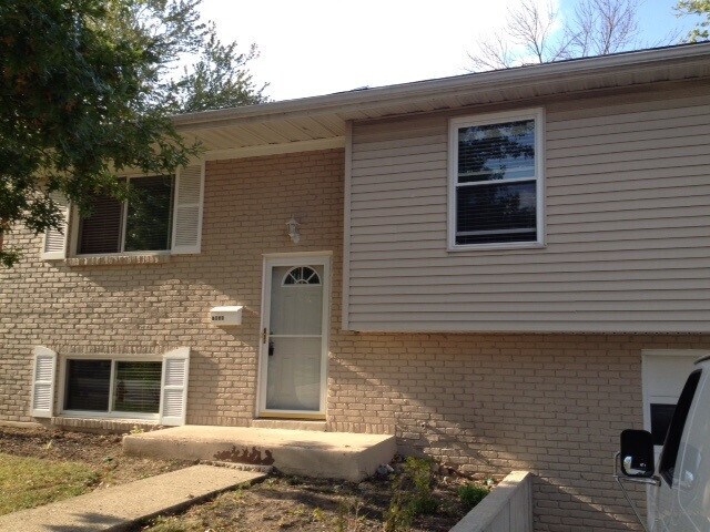
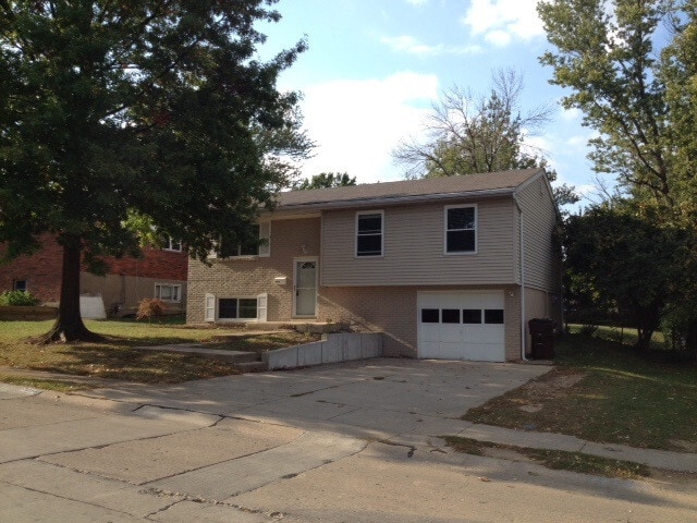
7058 Manderlay Dr
Florence, KY 41042
1 Day Ago
|
Edit
Favorites
859-393-0991
-
Bedrooms
3
-
Bathrooms
1.5
-
Square Feet
1,080 sq ft
-
Available
Available Now
Highlights
- Traditional Architecture
- Fireplace
- Mini Split Air Conditioners
- Living Room
- Laundry Room
- Forced Air Heating and Cooling System
7058 Manderlay Dr

Favorites
About This Home
Available Now
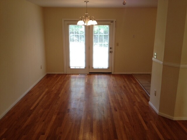
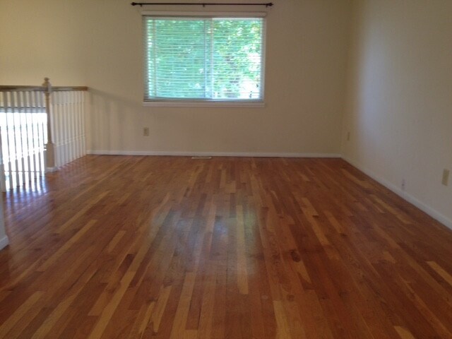
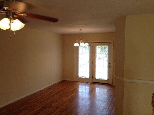
Large 3 Bedroom 2 full baths,hardwood floors and lower-level family room. Fenced in backyard with a nice concrete patio. Large two car driveway with garage. Available March 1st with a two-year lease.
7058 Manderlay Dr is a house located in Kenton County and the 41042 ZIP Code. This area is served by the Kenton County attendance zone.
* Price shown is base rent. Excludes user-selected optional fees and variable or usage-based fees and required charges due at or prior to move-in or at move-out. Price, availability, fees, and any applicable rent special are subject to change without notice.
* Square footage definitions vary. Displayed square footage is approximate.
Home Details
Home Type
Single Family Detached Home
Year Built
Built in 1969
Bedrooms and Bathrooms
1.5 Bathrooms
3 Bedrooms
Home Design
Traditional Architecture
Shingle Roof
Brick Exterior Construction
Bi-Level Home
Vinyl Siding
Poured Concrete
Interior Spaces
Fireplace
Living Room
Family Room
1,080 Sq Ft Home
Vinyl Clad Windows
Kitchen
Electric Cooktop
Electric Oven
Dishwasher
Laundry
Laundry Room
Listing and Financial Details
Negotiable Lease Term
Smoking Allowed
Lot Details
8,710 Sq Ft Lot
Parking
On-Street Parking
Driveway
Schools
Ja Caywood Elementary School
Turkey Foot Middle School
Dixie Heights High School
Utilities
Mini Split Air Conditioners
Forced Air Heating and Cooling System
Separate Meters
Furnace
Community Details
Overview
No Home Owners Association
Pet Policy
Dogs and Cats Allowed
1 Pet Allowed
Fees and Policies
The fees listed below are community-provided and may exclude utilities or add-ons. All payments are made directly to the property and are non-refundable unless otherwise specified.
-
Street Parking
Property Fee Disclaimer: Based on community-supplied data and independent market research. Subject to change without notice. May exclude fees for mandatory or optional services and usage-based utilities.
Contact
- Listed by Chris Bishop | Ken Perry Realty
- Phone Number
- Contact
-
Source
Northern Kentucky Association of REALTORS®
Copyright © 2026 Northern Kentucky Association of REALTORS. All rights reserved. All information provided by the listing agent/broker is deemed reliable but is not guaranteed and should be independently verified.
Location
Get Directions
Northern Kentucky is a sprawling region located just south of Cincinnati, Ohio. The Ohio River hugs the northern, eastern, and western portions of the region, serving as a scenic destination for all kinds of outdoor recreation throughout the year. Florence, Dayton, Newport, Covington, Burlington, and Highland Heights are among the many communities included in the Northern Kentucky region.
Each community in Northern Kentucky offers its own unique identity and sense of character. The rentals in the area are just as diverse as Northern Kentucky itself, ranging from luxury apartments to charming houses and everything in between. Getting around the region is a breeze with convenience to Interstates 71, 75, 275, and 471.
Learn more about living in Northern Kentucky
Amenities
- Air Conditioning
- Dishwasher
- Oven
- Range
Education
| Colleges & Universities | Distance | ||
|---|---|---|---|
| Colleges & Universities | Distance | ||
| Drive: | 13 min | 6.3 mi | |
| Drive: | 22 min | 13.9 mi | |
| Drive: | 26 min | 16.7 mi | |
| Drive: | 34 min | 19.7 mi |
7058 Manderlay Dr is within 13 minutes or 6.3 miles from Thomas More College. It is also near College of Mount St. Joseph and University of Cincinnati.
Schools


Public Elementary School
Grades PK-5
544 Students
Attendance Zone
Public Middle School
Grades 6-8
1,029 Students
Attendance Zone
Public High School
Grades 9-12
1,561 Students
Attendance Zone
Private Elementary & Middle School
Grades K-8
192 Students
Nearby
Private Elementary, Middle & High School
Grades K-12
147 Students
Nearby
School data provided by
 The GreatSchools Rating helps parents compare schools within a state based on a variety of school quality indicators and provides a helpful picture of how effectively each school serves all of its students. Ratings are on a scale of 1 (below average) to 10 (above average) and can include test scores, college readiness, academic progress, advanced courses, equity, discipline and attendance data. We also advise parents to visit schools, consider other information on school performance and programs, and consider family needs as part of the school selection process.
View GreatSchools Rating Methodology
Data provided by GreatSchools.org © 2026. All rights reserved.
View GreatSchools Rating Methodology
Data provided by GreatSchools.org © 2026. All rights reserved.
Transportation options available in Florence include The Banks Station - 2Nd & Main, located 12.6 miles from 7058 Manderlay Dr. 7058 Manderlay Dr is near Cincinnati/Northern Kentucky International, located 6.2 miles or 17 minutes away.
| Transit / Subway | Distance | ||
|---|---|---|---|
| Transit / Subway | Distance | ||
| Drive: | 20 min | 12.6 mi | |
| Drive: | 20 min | 12.7 mi | |
| Drive: | 21 min | 12.8 mi | |
| Drive: | 21 min | 12.9 mi | |
| Drive: | 21 min | 12.9 mi |
| Commuter Rail | Distance | ||
|---|---|---|---|
| Commuter Rail | Distance | ||
|
|
Drive: | 23 min | 13.6 mi |
| Airports | Distance | ||
|---|---|---|---|
| Airports | Distance | ||
|
Cincinnati/Northern Kentucky International
|
Drive: | 17 min | 6.2 mi |
Time and distance from 7058 Manderlay Dr.
| Shopping Centers | Distance | ||
|---|---|---|---|
| Shopping Centers | Distance | ||
| Walk: | 11 min | 0.6 mi | |
| Drive: | 4 min | 1.5 mi | |
| Drive: | 4 min | 1.7 mi |
7058 Manderlay Dr has 3 shopping centers within 1.7 miles, which is about a 4-minute drive. The miles and minutes will be for the farthest away property.
| Parks and Recreation | Distance | ||
|---|---|---|---|
| Parks and Recreation | Distance | ||
|
Boone County Arboretum
|
Drive: | 19 min | 10.4 mi |
|
John G. & Phyllis W. Smale Riverfront Park
|
Drive: | 20 min | 12.6 mi |
|
Wilson Commons
|
Drive: | 24 min | 14.8 mi |
|
Imago Earth Center
|
Drive: | 26 min | 15.9 mi |
|
Embshoff Woods
|
Drive: | 29 min | 17.5 mi |
7058 Manderlay Dr has 5 parks within 17.5 miles, including Boone County Arboretum, Embshoff Woods, and John G. & Phyllis W. Smale Riverfront Park.
| Hospitals | Distance | ||
|---|---|---|---|
| Hospitals | Distance | ||
| Drive: | 6 min | 3.0 mi | |
| Drive: | 13 min | 7.0 mi | |
| Drive: | 15 min | 7.3 mi |
7058 Manderlay Dr has 3 hospitals within 7.3 miles, the nearest is St. Elizabeth Florence which is 3.0 miles away and a 6 minute drive.
| Military Bases | Distance | ||
|---|---|---|---|
| Military Bases | Distance | ||
| Drive: | 89 min | 67.1 mi | |
| Drive: | 95 min | 72.2 mi | |
| Drive: | 97 min | 75.5 mi |
7058 Manderlay Dr has 3 military bases within 75.5 miles, the nearest is Gentile Air Force Station which is 67.1 miles away and a 89 minute drive.
You May Also Like
Similar Rentals Nearby
-
-
-
-
 3 Beds$1,930Total Monthly PriceTotal Monthly Price NewPrices include all required monthly fees.House for Rent
 -
 3 Beds$2,055Total Monthly PriceTotal Monthly Price NewPrices include all required monthly fees.House for Rent
 -
 3 Beds$1,860Total Monthly PriceTotal Monthly Price NewPrices include all required monthly fees.House for Rent
 -
 3 Beds$2,435Total Monthly PriceTotal Monthly Price NewPrices include all required monthly fees.House for Rent
 -
 4 Beds$2,440Total Monthly PriceTotal Monthly Price NewPrices include all required monthly fees.House for Rent
 -
 3 Beds$2,155Total Monthly PriceTotal Monthly Price NewPrices include all required monthly fees.House for Rent
 -
 3 Beds$2,285Total Monthly PriceTotal Monthly Price NewPrices include all required monthly fees.House for Rent


What Are Walk Score®, Transit Score®, and Bike Score® Ratings?
Walk Score® measures the walkability of any address. Transit Score® measures access to public transit. Bike Score® measures the bikeability of any address.
What is a Sound Score Rating?
A Sound Score Rating aggregates noise caused by vehicle traffic, airplane traffic and local sources
7058 Manderlay Dr
Florence, KY 41042