

$2,000 / Month
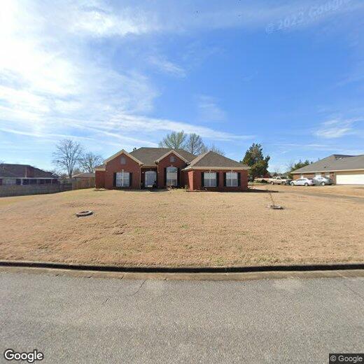
7048 Chip Curve
Montgomery, AL 36116
2 Weeks Ago
Favorites
7048 Chip Curve

Favorites
Check Back Soon for Upcoming Availability
| Beds | Baths | Average SF |
|---|---|---|
| 4 Bedrooms 4 Bedrooms 4 Br | 3 Baths 3 Baths 3 Ba | 2,593 SF |
Fees and Policies
The fees below are based on community-supplied data and may exclude additional fees and utilities.
- Parking
-
Garage--
About This Property
AVAILABLE NOW!!! MOVE IN READY!!! PIKE ROAD Schools. Refrigerator, washer and dryer included. Beautiful 4 bedroom & 3 full bath home in the Rolling Hills Subdivision. The golf course neighborhood and this house are zoned for the Pike Road School system. Fresh updates, paint, and LVP throughout. The roof was recently replaced and the home well maintained. Beautiful built-in cabinets and bookcases are found throughout the home. Kitchen offers lots of counter-top and cabinet space, stainless steel refrigerator, walk-in pantry, and breakfast area. The kitchen is open to the family room, which is spacious, has a gas log fireplace and trey ceilings. The floor-plan is split with the main bedroom and spare bedroom, along with their own bathrooms, on one side of the house. The other two bedrooms, a jack & jill bathroom, and laundry room are secluded on the other end of the house. The master suite is spacious, has trey ceilings, and multiple closets. The master bath includes a garden tub, separate walk-in shower, his & her vanity, skylight and large walk-in closet with custom shelving. Two car carport with attached storage. Call today for your personal tour. The home is move-in ready and won't last long.
7048 Chip Curve is a house located in Montgomery County and the 36116 ZIP Code. This area is served by the Pike Road attendance zone.
House Features
Hardwood Floors
Tile Floors
Security System
Vinyl Flooring
- Security System
- Hardwood Floors
- Tile Floors
- Vinyl Flooring
- Storage Space
- Fenced Lot
- Patio
Location
Get Directions
South Montgomery is less than 10 miles away from Downtown Montgomery and spans the area surrounding the Montgomery Regional Airport. Neighborhoods with ranch-style homes and well-manicured lawns fill the land between the airport and the downtown area. Just south of these neighborhoods sits rural land with scenic views and a few unincorporated communities, including Snowdoun, Hope Hull, and Ramer. From apartments and houses in a suburban setting to homes in communities with a small-town feel, the southern portion of Montgomery has something for everyone.
Learn more about living in South MontgomeryBelow are rent ranges for similar nearby apartments
Amenities
- Security System
- Hardwood Floors
- Tile Floors
- Vinyl Flooring
- Storage Space
- Fenced Lot
- Patio
Education
| Colleges & Universities | Distance | ||
|---|---|---|---|
| Colleges & Universities | Distance | ||
| Drive: | 22 min | 11.4 mi | |
| Drive: | 22 min | 12.2 mi | |
| Drive: | 24 min | 14.0 mi | |
| Drive: | 26 min | 15.3 mi |
7048 Chip Curve is within 22 minutes or 12.2 miles from Huntingdon College. It is also near Auburn Univ. at Montgomery and Alabama State University.
Schools


Public Elementary School
Grades 4-6
625 Students
Attendance Zone
Public Elementary School
Grades PK-3
855 Students
Attendance Zone
Public High School
Grades 9-12
906 Students
Nearby
Public High School
Grades 10-12
611 Students
Attendance Zone
Private Elementary, Middle & High School
Grades K-12
117 Students
Nearby
Private Elementary & Middle School
Grades PK-8
174 Students
Nearby
Private Elementary School
Grades PK-6
Nearby
School data provided by
 The GreatSchools Rating helps parents compare schools within a state based on a variety of school quality indicators and provides a helpful picture of how effectively each school serves all of its students. Ratings are on a scale of 1 (below average) to 10 (above average) and can include test scores, college readiness, academic progress, advanced courses, equity, discipline and attendance data. We also advise parents to visit schools, consider other information on school performance and programs, and consider family needs as part of the school selection process.
View GreatSchools Rating Methodology
Data provided by GreatSchools.org © 2025. All rights reserved.
View GreatSchools Rating Methodology
Data provided by GreatSchools.org © 2025. All rights reserved.
You May Also Like
Similar Rentals Nearby


What Are Walk Score®, Transit Score®, and Bike Score® Ratings?
Walk Score® measures the walkability of any address. Transit Score® measures access to public transit. Bike Score® measures the bikeability of any address.
What is a Sound Score Rating?
A Sound Score Rating aggregates noise caused by vehicle traffic, airplane traffic and local sources
7048 Chip Curve
Montgomery, AL 36116