

$5,150
/ Month
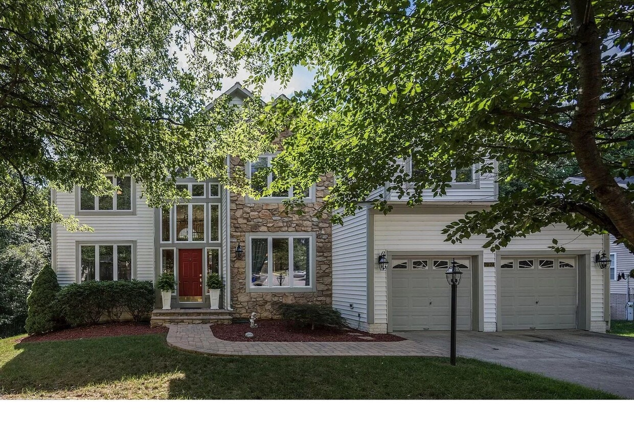
7024 Best Times Path
Columbia, MD 21044
Today
Favorites
301-655-0952
-
Bedrooms
5
-
Bathrooms
4
-
Square Feet
5,162 sq ft
-
Available
Available Aug 25
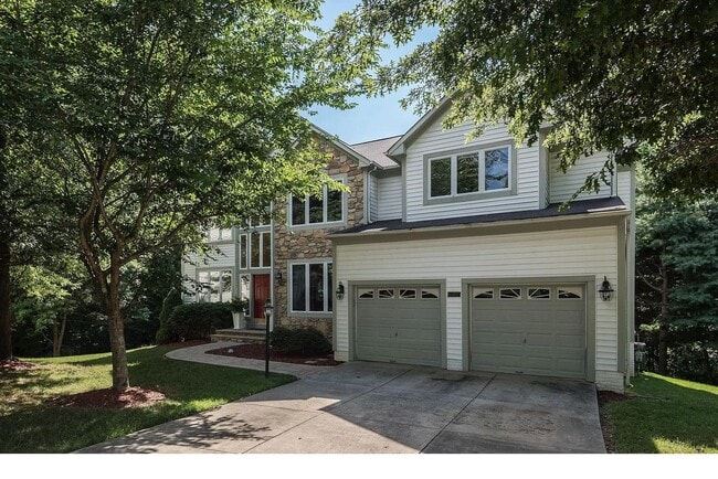
7024 Best Times Path

Favorites
About This Home
$5,150 deposit,
Available Aug 25
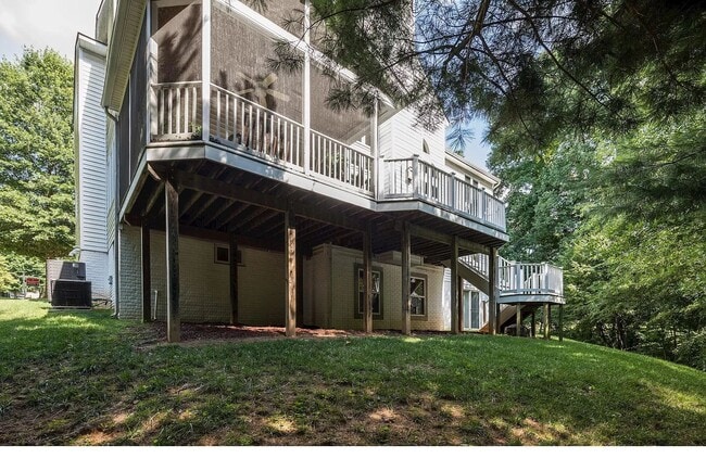
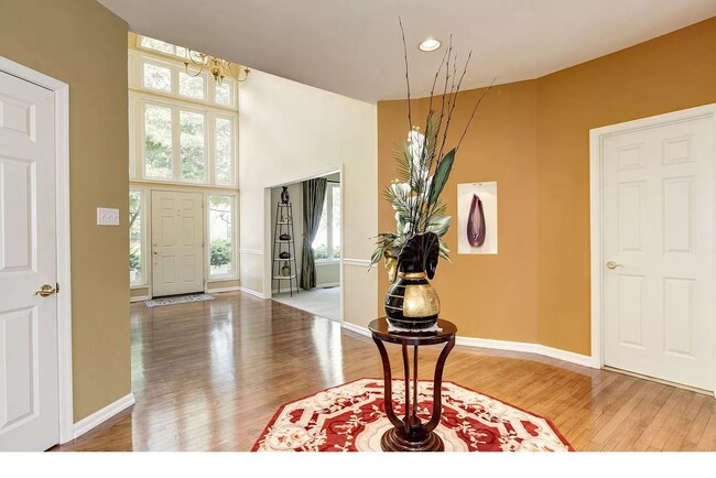
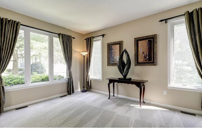
Amazing 5 bedroom, 4 bathroom house in Columbia. Amenities included: central air, central heat, deck, dishwasher, hardwood floors, stainless steel appliance, updated kitchen, updated bathroom, storage, washer dryer, yard, chimney , two-car garage , ev charging , additional refrigeration , full bar, pool table, and mini bar. Utilities included: cable and internet. Is pet friendly. Date Available: Aug 25th 2025. $5,150/month rent. $5,150 security deposit required. Please submit the form on this page or contact Jose at to learn more. This property is managed by a responsible landlord using Avail landlord software.
7024 Best Times Path is a house located in Howard County and the 21044 ZIP Code. This area is served by the Howard County Public Schools attendance zone.
* Price shown is base rent and may not include non-optional fees and utilities. Price, availability, fees, and any applicable rent special are subject to change without notice.
* Square footage definitions vary. Displayed square footage is approximate.
House Features
- Washer/Dryer
- Washer/Dryer Hookup
- Dishwasher
- Pool
Fees and Policies
The fees below are based on community-supplied data and may exclude additional fees and utilities.
- Dogs Allowed
-
Fees not specified
- Cats Allowed
-
Fees not specified
Contact
- Listed by Jose
- Phone Number
- Contact
Location
Get Directions
Amenities
- Washer/Dryer
- Washer/Dryer Hookup
- Dishwasher
- Pool
The two neighborhoods of Pheasant Ridge and Pointers Run make up the River Hill village in Clarksville, Maryland. Once a game farm, River Hill has grown into a thriving community that continues to respect the environmental integrity of the land, most notably through the preserved portion of green space called the Middle Patuxent Environmental Area.
While the city center of Clarksville sits a mile away from River Hill, there's no need to travel out of the neighborhood to shop or dine. The River Hill Village Center houses a grocery store and several eateries, including the River Hill Sports Grille, a popular spot where you can watch the game and fill up on burgers or tasty appetizers such as crab cake sliders.
If you're looking to get in some recreational time, River Hill has two options within close proximity of the apartments in the neighborhood.
Learn more about living in River Hill
Education
| Colleges & Universities | Distance | ||
|---|---|---|---|
| Colleges & Universities | Distance | ||
| Drive: | 10 min | 4.3 mi | |
| Drive: | 25 min | 16.2 mi | |
| Drive: | 25 min | 16.7 mi | |
| Drive: | 32 min | 18.3 mi |
7024 Best Times Path is within 10 minutes or 4.3 miles from Howard Community College. It is also near CCBC Cantonsville and UMBC.
Schools


Public Elementary School
Grades PK-5
812 Students
Attendance Zone
Public Middle School
Grades 6-8
649 Students
Attendance Zone
Public High School
Grades 9-12
1,424 Students
Attendance Zone
Private Elementary & Middle School
Grades PK-8
520 Students
Nearby
Private Elementary, Middle & High School
Grades PK-10
181 Students
Nearby
Private Elementary, Middle & High School
Grades PK-12
748 Students
Nearby
School data provided by
 The GreatSchools Rating helps parents compare schools within a state based on a variety of school quality indicators and provides a helpful picture of how effectively each school serves all of its students. Ratings are on a scale of 1 (below average) to 10 (above average) and can include test scores, college readiness, academic progress, advanced courses, equity, discipline and attendance data. We also advise parents to visit schools, consider other information on school performance and programs, and consider family needs as part of the school selection process.
View GreatSchools Rating Methodology
Data provided by GreatSchools.org © 2025. All rights reserved.
View GreatSchools Rating Methodology
Data provided by GreatSchools.org © 2025. All rights reserved.
Transportation options available in Columbia include Dorsey, located 12.6 miles from 7024 Best Times Path. 7024 Best Times Path is near Baltimore/Washington International Thurgood Marshall, located 18.9 miles or 27 minutes away, and Ronald Reagan Washington Ntl, located 29.1 miles or 49 minutes away.
| Transit / Subway | Distance | ||
|---|---|---|---|
| Transit / Subway | Distance | ||
|
|
Drive: | 19 min | 12.6 mi |
| Commuter Rail | Distance | ||
|---|---|---|---|
| Commuter Rail | Distance | ||
|
|
Drive: | 15 min | 9.4 mi |
|
|
Drive: | 18 min | 10.3 mi |
|
|
Drive: | 18 min | 10.5 mi |
|
|
Drive: | 18 min | 10.5 mi |
|
|
Drive: | 22 min | 15.5 mi |
| Airports | Distance | ||
|---|---|---|---|
| Airports | Distance | ||
|
Baltimore/Washington International Thurgood Marshall
|
Drive: | 27 min | 18.9 mi |
|
Ronald Reagan Washington Ntl
|
Drive: | 49 min | 29.1 mi |
Time and distance from 7024 Best Times Path.
| Shopping Centers | Distance | ||
|---|---|---|---|
| Shopping Centers | Distance | ||
| Drive: | 5 min | 2.5 mi | |
| Drive: | 7 min | 3.1 mi | |
| Drive: | 8 min | 3.3 mi |
7024 Best Times Path has 3 shopping centers within 3.3 miles, which is about a 8-minute drive. The miles and minutes will be for the farthest away property.
| Parks and Recreation | Distance | ||
|---|---|---|---|
| Parks and Recreation | Distance | ||
|
Browns Bridge Recreation Area
|
Drive: | 9 min | 4.9 mi |
|
Brighton Dam's Azalea Garden
|
Drive: | 12 min | 6.5 mi |
|
Pigtail Recreation Area
|
Drive: | 14 min | 6.5 mi |
|
Clark's Elioak Farm
|
Drive: | 13 min | 7.1 mi |
|
Maydale Conservation Park and Nature Center
|
Drive: | 20 min | 10.6 mi |
7024 Best Times Path has 5 parks within 10.6 miles, including Browns Bridge Recreation Area, Clark's Elioak Farm, and Brighton Dam's Azalea Garden.
| Hospitals | Distance | ||
|---|---|---|---|
| Hospitals | Distance | ||
| Drive: | 9 min | 4.0 mi | |
| Drive: | 17 min | 9.9 mi | |
| Drive: | 21 min | 13.6 mi |
7024 Best Times Path has 3 hospitals within 13.6 miles, the nearest is Howard County General Hospital which is 4.0 miles away and a 9 minute drive.
| Military Bases | Distance | ||
|---|---|---|---|
| Military Bases | Distance | ||
| Drive: | 22 min | 13.7 mi |
7024 Best Times Path is 13.7 miles and a 22 minute drive from Fort George Meade.
You May Also Like
Similar Rentals Nearby


What Are Walk Score®, Transit Score®, and Bike Score® Ratings?
Walk Score® measures the walkability of any address. Transit Score® measures access to public transit. Bike Score® measures the bikeability of any address.
What is a Sound Score Rating?
A Sound Score Rating aggregates noise caused by vehicle traffic, airplane traffic and local sources
7024 Best Times Path
Columbia, MD 21044