
$2,500
/ Month
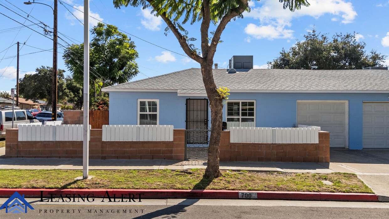
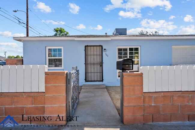
700 S Kalisher St
San Fernando, CA 91340
Today
Favorites
661-291-2271
-
Bedrooms
2
-
Bathrooms
1
-
Square Feet
675 sq ft
-
Available
Available Now
700 S Kalisher St

Favorites
About This Home
$2,500 deposit,
Available Now
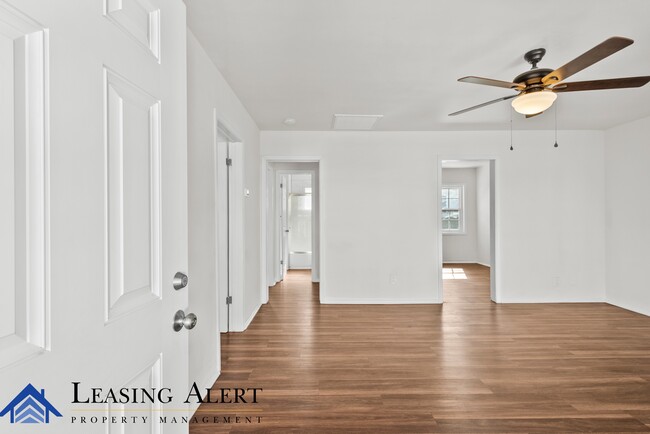
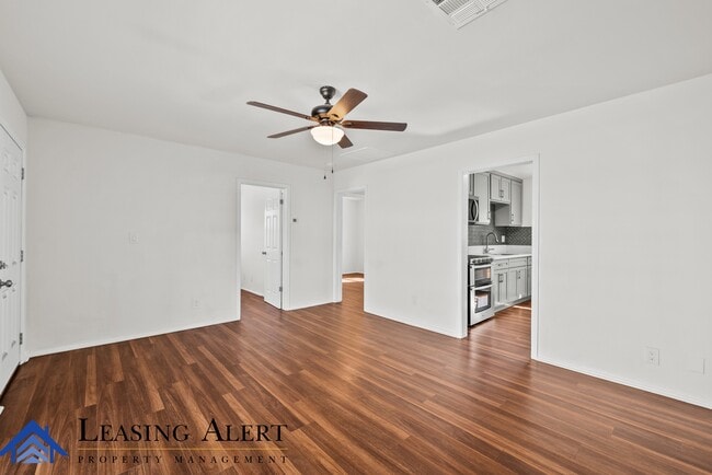
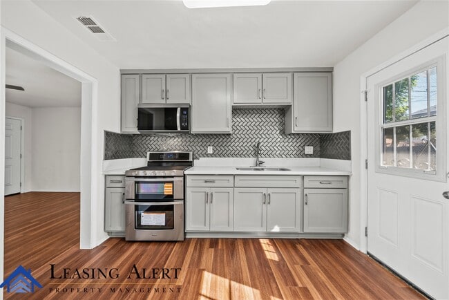
Welcome to 700 S Kalisher, a beautifully updated 2-bedroom, 1-bath home in San Fernando. This 675-square-foot home features a brand-new central air and heating system, fresh paint, new vinyl flooring, and a completely new stove, oven, and microwave. Washer and dryer hookups add convenience, while the included garage provides secure parking and extra storage. With its modern upgrades and prime location near local shops, dining, and freeway access, this charming home offers comfort and style in one perfect package. Tenant is responsible for all utilities.
700 S Kalisher St is a house located in Los Angeles County and the 91340 ZIP Code. This area is served by the Los Angeles Unified attendance zone.
* Price shown is base rent. Excludes user-selected optional fees and variable or usage-based fees and required charges due at or prior to move-in or at move-out. Price, availability, fees, and any applicable rent special are subject to change without notice.
* Square footage definitions vary. Displayed square footage is approximate.
Contact
- Listed by Assistant Property Manager
- Phone Number
- Contact
Location
Get Directions
Nestled at the foothills of the San Gabriel Mountains, San Fernando is a small city in the northwestern region of Los Angeles County. Situated between Interstates 5 and 210, getting around from San Fernando is a breeze.
In addition to stunning mountain views, San Fernando boasts endless opportunities for outdoor recreation with close proximity to a number of parks such as Hansen Dam Recreation Center, Veterans Memorial Community Regional Park, Wilson Canyon Park, and O’Melveny Park. San Fernando is home to a diverse range of shopping and dining options, including the San Fernando Swap Meet and authentic Latin American cuisine. Discovery Cube Los Angeles and Nethercutt Museum are also close to San Fernando.
Learn more about living in San Fernando
Education
| Colleges & Universities | Distance | ||
|---|---|---|---|
| Colleges & Universities | Distance | ||
| Drive: | 6 min | 3.4 mi | |
| Drive: | 12 min | 6.8 mi | |
| Drive: | 14 min | 9.5 mi | |
| Drive: | 14 min | 9.6 mi |
700 S Kalisher St is within 6 minutes or 3.4 miles from Mission College. It is also near Cal State Northridge and Valley College.
Schools


Charter Elementary, Middle & High School
Grades K-12
2,877 Students
Nearby
Public Elementary School
Grades K-5
482 Students
Attendance Zone
Public Middle School
Grades 6-8
524 Students
Attendance Zone
Public High School
Grades 9-12
2,220 Students
Attendance Zone
Private Elementary & Middle School
Grades PK-8
Nearby
Private Elementary & Middle School
Grades PK-8
174 Students
Nearby
Private High School
Grades 9-12
984 Students
Nearby
School data provided by
 The GreatSchools Rating helps parents compare schools within a state based on a variety of school quality indicators and provides a helpful picture of how effectively each school serves all of its students. Ratings are on a scale of 1 (below average) to 10 (above average) and can include test scores, college readiness, academic progress, advanced courses, equity, discipline and attendance data. We also advise parents to visit schools, consider other information on school performance and programs, and consider family needs as part of the school selection process.
View GreatSchools Rating Methodology
Data provided by GreatSchools.org © 2025. All rights reserved.
View GreatSchools Rating Methodology
Data provided by GreatSchools.org © 2025. All rights reserved.
Transportation options available in San Fernando include North Hollywood Station, located 10.0 miles from 700 S Kalisher St. 700 S Kalisher St is near Bob Hope, located 9.0 miles or 13 minutes away, and Los Angeles International, located 27.2 miles or 36 minutes away.
| Transit / Subway | Distance | ||
|---|---|---|---|
| Transit / Subway | Distance | ||
|
|
Drive: | 13 min | 10.0 mi |
| Commuter Rail | Distance | ||
|---|---|---|---|
| Commuter Rail | Distance | ||
|
|
Drive: | 3 min | 1.2 mi |
|
|
Drive: | 10 min | 5.6 mi |
|
|
Drive: | 9 min | 7.2 mi |
|
|
Drive: | 16 min | 9.1 mi |
|
|
Drive: | 17 min | 9.1 mi |
| Airports | Distance | ||
|---|---|---|---|
| Airports | Distance | ||
|
Bob Hope
|
Drive: | 13 min | 9.0 mi |
|
Los Angeles International
|
Drive: | 36 min | 27.2 mi |
Time and distance from 700 S Kalisher St.
| Shopping Centers | Distance | ||
|---|---|---|---|
| Shopping Centers | Distance | ||
| Walk: | 5 min | 0.3 mi | |
| Walk: | 6 min | 0.3 mi | |
| Walk: | 7 min | 0.4 mi |
700 S Kalisher St has 3 shopping centers within 0.4 mile, which is about a 7-minute walk. The miles and minutes will be for the farthest away property.
| Parks and Recreation | Distance | ||
|---|---|---|---|
| Parks and Recreation | Distance | ||
|
El Cariso Regional Park
|
Drive: | 7 min | 3.5 mi |
|
Veterans Memorial Park
|
Drive: | 11 min | 4.6 mi |
|
Aliso Canyon Park
|
Drive: | 12 min | 6.6 mi |
|
Cal State Northridge Botanic Garden
|
Drive: | 12 min | 7.4 mi |
|
Placerita Canyon State Park
|
Drive: | 15 min | 11.5 mi |
700 S Kalisher St has 5 parks within 11.5 miles, including El Cariso Regional Park, Veterans Memorial Park, and Aliso Canyon Park.
| Hospitals | Distance | ||
|---|---|---|---|
| Hospitals | Distance | ||
| Walk: | 13 min | 0.7 mi | |
| Drive: | 8 min | 4.3 mi | |
| Drive: | 7 min | 4.6 mi |
700 S Kalisher St has 3 hospitals within 4.6 miles, the nearest is Providence Holy Cross Medical Center which is 0.7 mile away and a 13 minute walk.
| Military Bases | Distance | ||
|---|---|---|---|
| Military Bases | Distance | ||
| Drive: | 37 min | 29.8 mi |
700 S Kalisher St is 29.8 miles and a 37 minute drive from Los Angeles Air Force Base.
You May Also Like
Similar Rentals Nearby


What Are Walk Score®, Transit Score®, and Bike Score® Ratings?
Walk Score® measures the walkability of any address. Transit Score® measures access to public transit. Bike Score® measures the bikeability of any address.
What is a Sound Score Rating?
A Sound Score Rating aggregates noise caused by vehicle traffic, airplane traffic and local sources

700 S Kalisher St
San Fernando, CA 91340