
$2,600
/ Month
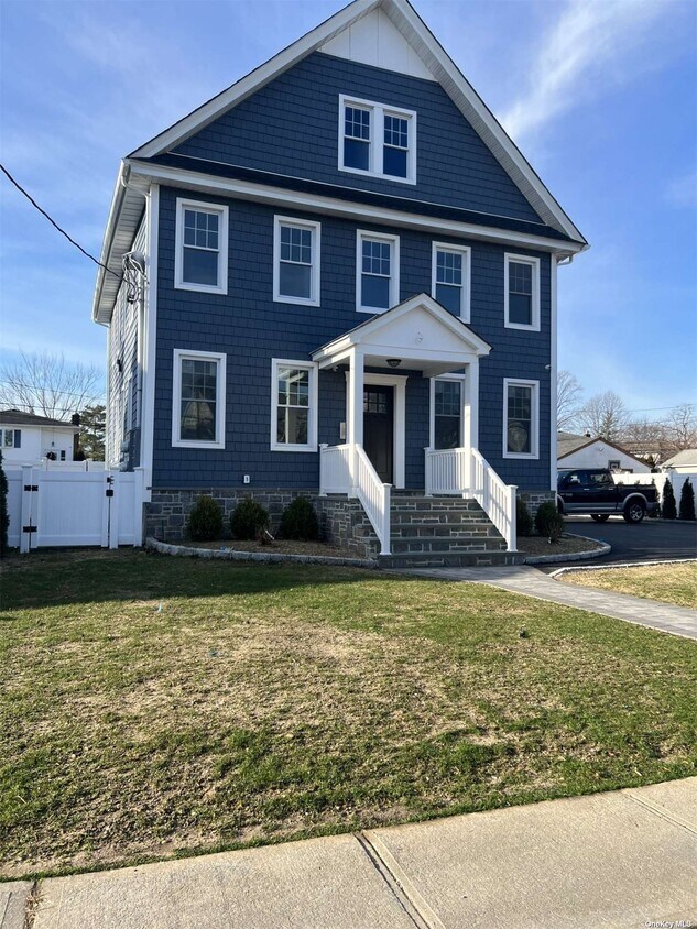
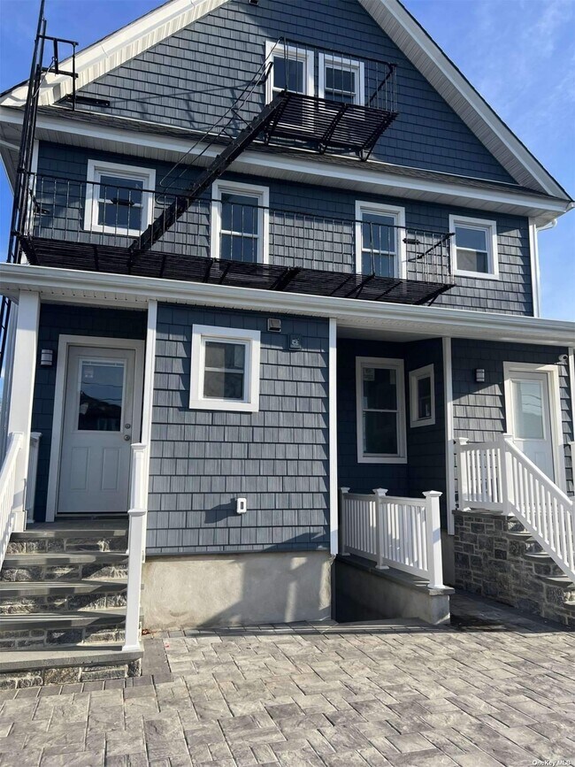
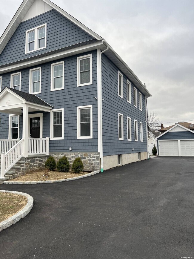
70 Peterson Pl Unit 1B
Lynbrook, NY 11563
Favorites
70 Peterson Pl Unit 1B

Favorites
Check Back Soon for Upcoming Availability
| Beds | Baths | Average SF |
|---|---|---|
| 1 Bedroom 1 Bedroom 1 Br | 1 Bath 1 Bath 1 Ba | — |
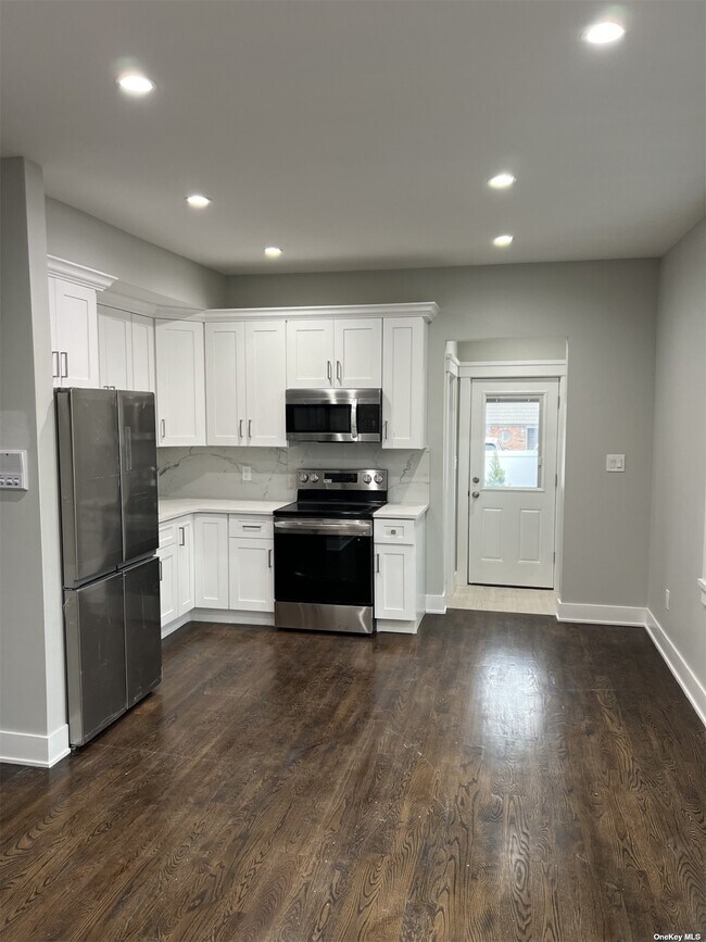
About This Property
Welcome to your new rental home in the heart of Lynbrook! This inviting 1-bedroom 1 bath rental is located in a prime location. A designed space provides a warm and inviting atmosphere. The open floor plan connects the living space to the kitchen,open layout equipped with modern appliances and white cabinets . it has backyard,assigned parking . Conveniently located near public transportation and shopping centers. Don't miss the opportunity to make this space your own and experience the comfort and convenience it has to offer. Based on information submitted to the MLS GRID as of [see last changed date above]. All data is obtained from various sources and may not have been verified by broker or MLS GRID. Supplied Open House Information is subject to change without notice. All information should be independently reviewed and verified for accuracy. Properties may or may not be listed by the office/agent presenting the information. Some IDX listings have been excluded from this website. Prices displayed on all Sold listings are the Last Known Listing Price and may not be the actual selling price.
70 Peterson Pl is an apartment community located in Nassau County and the 11563 ZIP Code.
70 Peterson Pl,
Lynbrook,
NY
11563
Lynbrook sits on the South Shore of Long Island in Nassau County, about 20 miles from Midtown Manhattan, making it a well-positioned base for anyone who wants suburban calm without losing easy access to New York City. The Long Island Rail Road stops right in the village, so the commute into the city is straightforward and reliable. Lynbrook itself covers just three square miles, yet the compact footprint gives the area a grounded, close-knit feel that larger towns rarely achieve. The commercial stretch along Sunrise Highway keeps daily errands simple, with local shops and services within reach on foot or by car. The name "Lynbrook" has an interesting origin: it was formed by reversing the syllables of "Brooklyn," a nod to the many former Brooklyn residents who settled here in the late 1800s.
Learn more about living in Lynbrook
Education
| Colleges & Universities | Distance | ||
|---|---|---|---|
| Colleges & Universities | Distance | ||
| Drive: | 8 min | 4.4 mi | |
| Drive: | 13 min | 5.7 mi | |
| Drive: | 12 min | 6.8 mi | |
| Drive: | 16 min | 8.1 mi |
70 Peterson Pl Unit 1B is within 8 minutes or 4.4 miles from Molloy College. It is also near Adelphi University and Hofstra University.
Transportation options available in Lynbrook include Far Rockaway-Mott Avenue, located 5.7 miles from 70 Peterson Pl Unit 1B. 70 Peterson Pl Unit 1B is near John F Kennedy International, located 8.9 miles or 15 minutes away, and LaGuardia, located 15.9 miles or 25 minutes away.
| Transit / Subway | Distance | ||
|---|---|---|---|
| Transit / Subway | Distance | ||
|
|
Drive: | 11 min | 5.7 mi |
|
|
Drive: | 12 min | 6.5 mi |
|
|
Drive: | 13 min | 8.6 mi |
|
|
Drive: | 15 min | 9.0 mi |
|
|
Drive: | 16 min | 9.1 mi |
| Commuter Rail | Distance | ||
|---|---|---|---|
| Commuter Rail | Distance | ||
|
|
Walk: | 12 min | 0.6 mi |
|
|
Drive: | 4 min | 1.5 mi |
|
|
Drive: | 4 min | 1.8 mi |
|
|
Drive: | 5 min | 2.2 mi |
|
|
Drive: | 5 min | 2.3 mi |
| Airports | Distance | ||
|---|---|---|---|
| Airports | Distance | ||
|
John F Kennedy International
|
Drive: | 15 min | 8.9 mi |
|
LaGuardia
|
Drive: | 25 min | 15.9 mi |
Walkability Near 70 Peterson Pl Lynbrook, NY 11563
Getting Around
 What do Walkability, Transit, Drivability, and Bikeability mean?
Walkability measures the walking distance to day-to-day needs.
Transit measures access to public transportation.
Drivability measures congestion, parking availability, and access to major roads.
Bikeability measures the suitability for cycling.
How It Works
What do Walkability, Transit, Drivability, and Bikeability mean?
Walkability measures the walking distance to day-to-day needs.
Transit measures access to public transportation.
Drivability measures congestion, parking availability, and access to major roads.
Bikeability measures the suitability for cycling.
How It Works
Moderately Walkable
Walkability
70
/ 100
Some Public Transit
Transit
50
/ 100
Fairly Drivable
Drivability
50
/ 100
Fairly Bikeable
Bikeability
50
/ 100
Scores provided by
-
Soundscore™
-
/ 100
Traffic
-Airport
-Businesses
-Scores provided by
HowLoud What is a Sound Score Rating? A Sound Score Rating aggregates noise caused by vehicle traffic, airplane traffic and local sources. How It WorksTime and distance from 70 Peterson Pl Unit 1B.
| Shopping Centers | Distance | ||
|---|---|---|---|
| Shopping Centers | Distance | ||
| Walk: | 7 min | 0.4 mi | |
| Walk: | 13 min | 0.7 mi | |
| Walk: | 13 min | 0.7 mi |
70 Peterson Pl Unit 1B has 3 shopping centers within 0.7 mile, which is about a 13-minute walk. The miles and minutes will be for the farthest away property.
| Parks and Recreation | Distance | ||
|---|---|---|---|
| Parks and Recreation | Distance | ||
|
Center for Science Teaching and Learning
|
Drive: | 4 min | 2.0 mi |
|
Valley Stream State Park
|
Drive: | 6 min | 3.2 mi |
|
Hempstead Lake State Park
|
Drive: | 7 min | 3.6 mi |
|
Brookville Park
|
Drive: | 9 min | 5.1 mi |
|
Marine Nature Study Area
|
Drive: | 11 min | 5.1 mi |
70 Peterson Pl Unit 1B has 5 parks within 5.1 miles, including Center for Science Teaching and Learning, Valley Stream State Park, and Hempstead Lake State Park.
| Hospitals | Distance | ||
|---|---|---|---|
| Hospitals | Distance | ||
| Drive: | 7 min | 3.9 mi | |
| Drive: | 13 min | 5.9 mi | |
| Drive: | 15 min | 8.0 mi |
70 Peterson Pl Unit 1B has 3 hospitals within 8.0 miles, the nearest is Mercy Medical Center which is 3.9 miles away and a 7 minute drive.
| Military Bases | Distance | ||
|---|---|---|---|
| Military Bases | Distance | ||
| Drive: | 23 min | 14.1 mi | |
| Drive: | 28 min | 17.7 mi | |
| Drive: | 36 min | 19.2 mi |
70 Peterson Pl Unit 1B has 3 military bases within 19.2 miles, the nearest is Fort Totten US Govt Reservation which is 14.1 miles away and a 23 minute drive.
You May Also Like
Similar Rentals Nearby


What Are Walk Score®, Transit Score®, and Bike Score® Ratings?
Walk Score® measures the walkability of any address. Transit Score® measures access to public transit. Bike Score® measures the bikeability of any address.
What is a Sound Score Rating?
A Sound Score Rating aggregates noise caused by vehicle traffic, airplane traffic and local sources.

70 Peterson Pl
Lynbrook, NY 11563