
$4,500 / Month
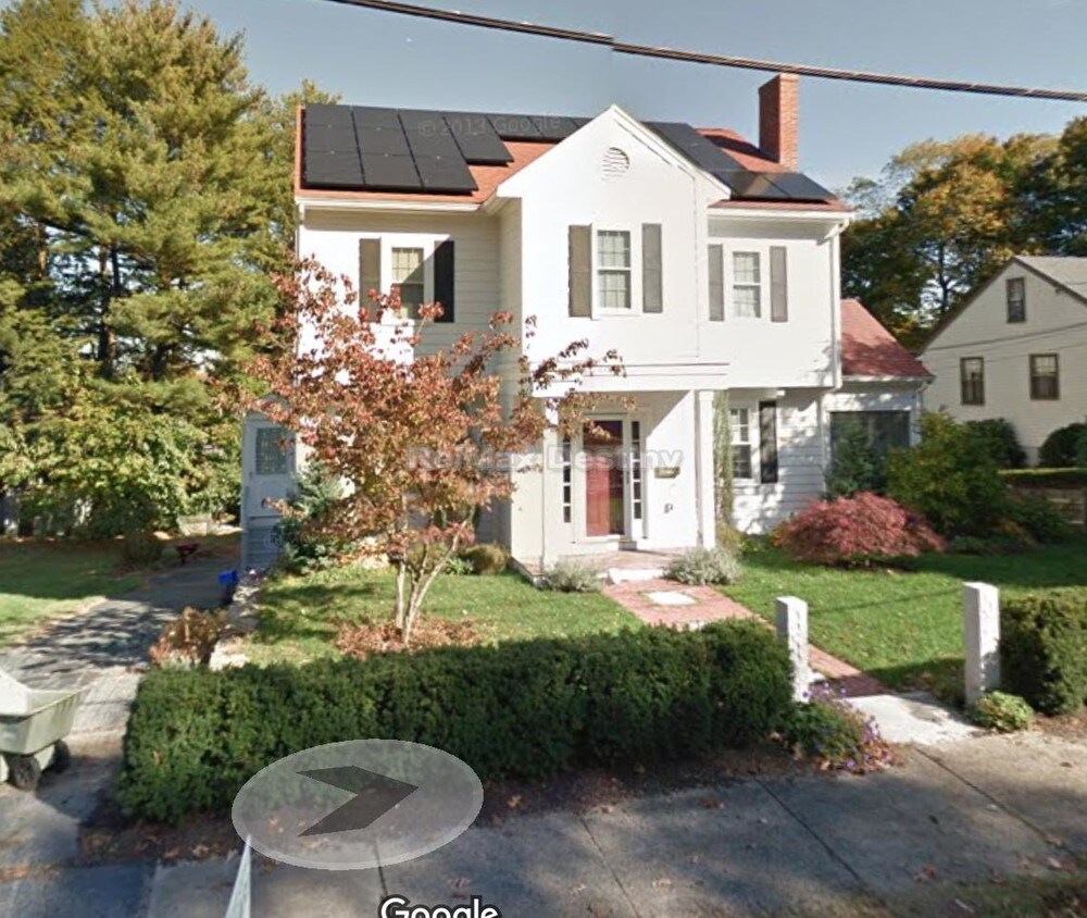
7 Aerial St
Lexington, MA 02421
2 Weeks Ago
Favorites
7 Aerial St

Favorites
Check Back Soon for Upcoming Availability
| Beds | Baths | Average SF |
|---|---|---|
| 4 Bedrooms 4 Bedrooms 4 Br | 2 Baths 2 Baths 2 Ba | 1,860 SF |
Fees and Policies
The fees below are based on community-supplied data and may exclude additional fees and utilities.
- Dogs Allowed
-
Fees not specified
-
Restrictions:0
- Cats Allowed
-
Fees not specified
-
Restrictions:0
About This Property
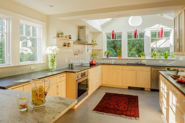
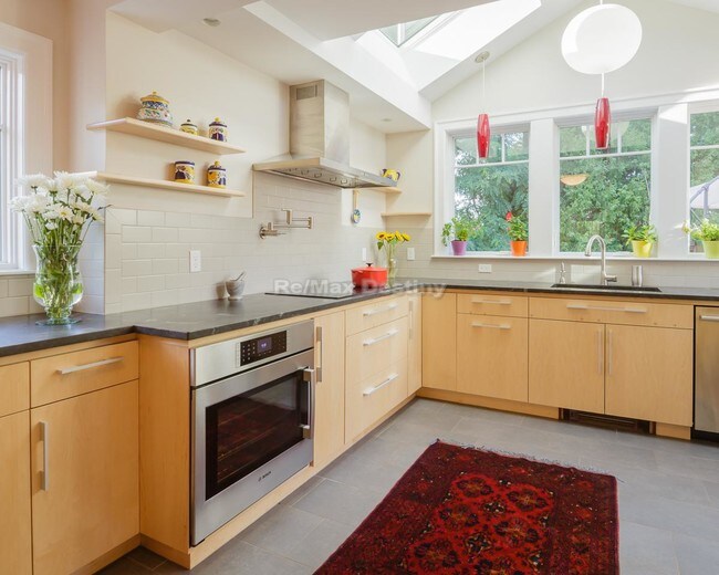
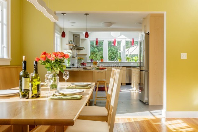
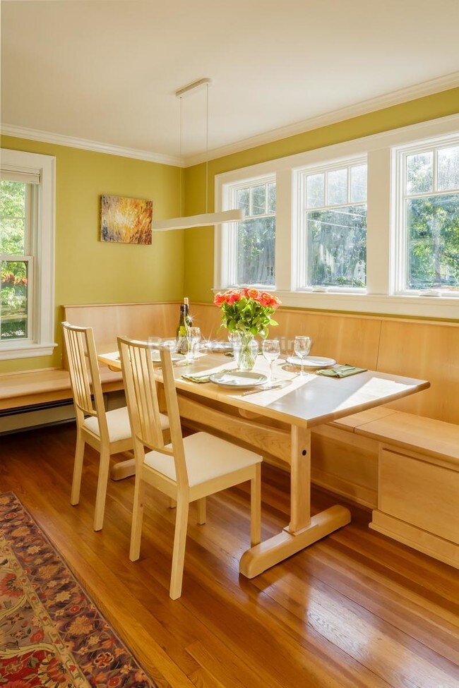
4 bedroom, 2 bathroom house with a dream kitchen that opens up to a 600 sq ft deck. Chef's kitchen meticulously planned out, perfect not only for the chef but also your guests so that cooking can be a spectator sport! A few special touches in the house include: - Full house air purifier to reduce allergens - Heated floor in the kitchen - Solar panels - Heated toilet seats - Working fireplace - Power outlet for electric car charging The home is being rented FULLY FURNISHED complete with linens, pots and pans, utensils, dishes. It even comes with a piano! It's ready to move in and live - just bring your clothes! You also have the option to rent car(s), one of which is electric! Next to conservation land and a park, the house is on a street with no traffic. Close to the Minuteman bike path, Trader Joe's and Walgreens are also conveniently close by. Easy access to Rte-2 and 7 minute drive to the Alewife subway stop
7 Aerial St is a house located in Middlesex County and the 02421 ZIP Code. This area is served by the Lexington attendance zone.
Location
Get Directions
Much of Lexington’s local culture is rooted in the town’s role in the American Revolution, but the community is much more than a historical landmark. Sitting only about 30 minutes outside downtown Boston, folks renting in Lexington are far enough removed from the urban core to enjoy a quiet lifestyle while close enough for an easy commute.
Dozens of public parks dot the community, offering endless opportunities for enjoying nature right in your own neighborhood. The Minuteman Bikeway connects Lexington to Bedford in the north and Arlington and Cambridge in the south. The schools in the area get excellent marks and the crime rate is among the lowest in the nation, so the community is highly desirable for families.
Learn more about living in LexingtonBelow are rent ranges for similar nearby apartments
Education
| Colleges & Universities | Distance | ||
|---|---|---|---|
| Colleges & Universities | Distance | ||
| Drive: | 11 min | 4.8 mi | |
| Drive: | 10 min | 5.5 mi | |
| Drive: | 11 min | 5.9 mi | |
| Drive: | 12 min | 6.3 mi |
7 Aerial St is within 11 minutes or 4.8 miles from Bentley University. It is also near Tufts Univ., Medford and Lesley University, Porter.
Schools


Public Elementary School
Grades PK-5
507 Students
Nearby
Public Elementary School
Grades K-5
451 Students
Attendance Zone
Public Middle School
Grades 6-8
823 Students
Attendance Zone
Public High School
Grades 9-12
2,303 Students
Attendance Zone
Private Elementary & Middle School
Grades PK-8
175 Students
Nearby
Private Middle & High School
Grades 8-12
31 Students
Nearby
School data provided by
 The GreatSchools Rating helps parents compare schools within a state based on a variety of school quality indicators and provides a helpful picture of how effectively each school serves all of its students. Ratings are on a scale of 1 (below average) to 10 (above average) and can include test scores, college readiness, academic progress, advanced courses, equity, discipline and attendance data. We also advise parents to visit schools, consider other information on school performance and programs, and consider family needs as part of the school selection process.
View GreatSchools Rating Methodology
Data provided by GreatSchools.org © 2025. All rights reserved.
View GreatSchools Rating Methodology
Data provided by GreatSchools.org © 2025. All rights reserved.
Transportation options available in Lexington include Alewife Station, located 4.2 miles from 7 Aerial St. 7 Aerial St is near General Edward Lawrence Logan International, located 13.2 miles or 24 minutes away.
| Transit / Subway | Distance | ||
|---|---|---|---|
| Transit / Subway | Distance | ||
|
|
Drive: | 8 min | 4.2 mi |
| Drive: | 7 min | 4.3 mi | |
| Drive: | 10 min | 5.3 mi | |
|
|
Drive: | 11 min | 5.6 mi |
|
|
Drive: | 10 min | 5.8 mi |
| Commuter Rail | Distance | ||
|---|---|---|---|
| Commuter Rail | Distance | ||
|
|
Drive: | 6 min | 3.2 mi |
|
|
Drive: | 7 min | 3.6 mi |
|
|
Drive: | 8 min | 4.3 mi |
|
|
Drive: | 9 min | 4.3 mi |
|
|
Drive: | 8 min | 4.5 mi |
| Airports | Distance | ||
|---|---|---|---|
| Airports | Distance | ||
|
General Edward Lawrence Logan International
|
Drive: | 24 min | 13.2 mi |
Time and distance from 7 Aerial St.
| Shopping Centers | Distance | ||
|---|---|---|---|
| Shopping Centers | Distance | ||
| Walk: | 15 min | 0.8 mi | |
| Drive: | 5 min | 2.9 mi | |
| Drive: | 7 min | 3.3 mi |
7 Aerial St has 3 shopping centers within 3.3 miles, which is about a 7-minute walk. The miles and minutes will be for the farthest away property.
| Parks and Recreation | Distance | ||
|---|---|---|---|
| Parks and Recreation | Distance | ||
|
Mass Audubon's Habitat Education Center and Wildlife Sanctuary
|
Drive: | 7 min | 2.9 mi |
|
Beaver Brook Reservation
|
Drive: | 8 min | 3.6 mi |
|
Harvard-Smithsonian Center for Astrophysics
|
Drive: | 11 min | 5.9 mi |
|
Longfellow National Historic Site
|
Drive: | 12 min | 6.2 mi |
|
Harvard Museum of Natural History
|
Drive: | 13 min | 6.6 mi |
7 Aerial St has 5 parks within 6.6 miles, including Mass Audubon's Habitat Education Center and Wildlife Sanctuary, Beaver Brook Reservation, and Harvard-Smithsonian Center for Astrophysics.
| Hospitals | Distance | ||
|---|---|---|---|
| Hospitals | Distance | ||
| Drive: | 6 min | 2.9 mi | |
| Drive: | 12 min | 6.3 mi | |
| Drive: | 11 min | 6.3 mi |
7 Aerial St has 3 hospitals within 6.3 miles, the nearest is McLean Hospital Corporation which is 2.9 miles away and a 6 minute drive.
| Military Bases | Distance | ||
|---|---|---|---|
| Military Bases | Distance | ||
| Drive: | 13 min | 6.0 mi | |
| Drive: | 31 min | 18.3 mi |
7 Aerial St is 6.0 miles from Hanscom Air Force Base, and is convenient to other military bases, including US Military Reservation.
You May Also Like
Similar Rentals Nearby


What Are Walk Score®, Transit Score®, and Bike Score® Ratings?
Walk Score® measures the walkability of any address. Transit Score® measures access to public transit. Bike Score® measures the bikeability of any address.
What is a Sound Score Rating?
A Sound Score Rating aggregates noise caused by vehicle traffic, airplane traffic and local sources

7 Aerial St
Lexington, MA 02421