

$4,600 / Month
685 High St
Palo Alto, CA 94301
2 Weeks Ago
Favorites
685 High St

Favorites
Check Back Soon for Upcoming Availability
| Beds | Baths | Average SF |
|---|---|---|
| 2 Bedrooms 2 Bedrooms 2 Br | 2.5 Baths 2.5 Baths 2.5 Ba | 1,530 SF |
About This Property
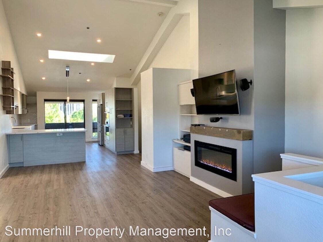
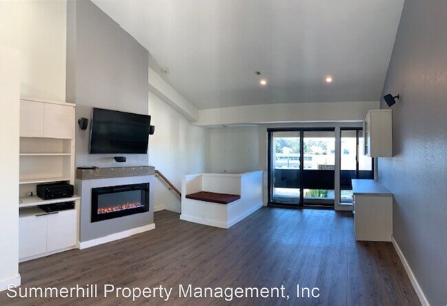
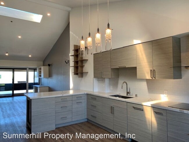
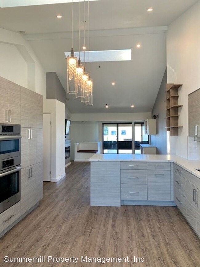
(650) 815-8588 - FABULOUS heart of downtown PA, walk to everything including the train. Minutes to Stanford, Google, & freeways. - Gorgeous, updated condo, in the very walkable downtown area! First floor: open plan living room, dining, kitchen with all high end appliances, loads of counter space and cabinets. Vaulted ceiling and skylights make everything bright and welcoming! Wall mounted big screen TV, Fireplace for ambience (but no flames!!). Built in desk. Second floor (downstairs) has two bedrooms, each with ensuite bath, and laundry area, with Energy efficient washer and dryer. Upstairs, floors are gorgeous grey laminate floors, downstairs gorgeous brand new plush carpet. 2 reserved parking spaces, in secure underground garage, with a dedicated secure storage locker. Schools are: Addison Elementary School, Grades: K-5, Distance: 0.7 mi Rated: 8/10 Greene Middle School (Formerly Jordan), Grades: 6-8, Distance: 1.7 mi Rated: 9/10 Palo Alto High School, Grades: 9-12, Distance: 0.5 mi Rated: 9/10 Tenant to verify availability. Two minute walk to the train station or jump in your car and zip to either 101 or 280! Please contact Teri Berwick (BRE 01705674) at 650 815 8588 for an appointment to view. Professionally managed by Summerhill Property Management, Inc. (BRE 01523660) Please: no smoking, no pets. (RLNE6079949)
685 High St is a house located in Santa Clara County and the 94301 ZIP Code. This area is served by the Palo Alto Unified attendance zone.
Location
Get Directions
An outgoing vibe emanates from the Downtown North neighborhood. Downtown North provides an energy like no other in Palo Alto. Still, locals enjoy being part of a tight-knit community focused on safety, communication and most importantly: fun.
Palo Alto has one of the best public school systems in California, houses Stanford University, and has some of the most delicious dining and exciting shopping opportunities in the Bay Area. The placement of the city provides convenience for commuters to San Jose 24 miles to the Southeast or San Francisco 32 miles to the Northwest.
Learn more about living in Downtown Palo AltoBelow are rent ranges for similar nearby apartments
| Beds | Average Size | Lowest | Typical | Premium |
|---|---|---|---|---|
| Studio Studio Studio | 490 Sq Ft | $2,500 | $3,649 | $4,070 |
| 1 Bed 1 Bed 1 Bed | 635-640 Sq Ft | $2,350 | $4,074 | $5,490 |
| 2 Beds 2 Beds 2 Beds | 922 Sq Ft | $4,250 | $6,215 | $13,190 |
| 3 Beds 3 Beds 3 Beds | 1855 Sq Ft | $7,600 | $8,275 | $8,950 |
| 4 Beds 4 Beds 4 Beds | 2710 Sq Ft | $11,000 | $13,000 | $15,000 |
Education
| Colleges & Universities | Distance | ||
|---|---|---|---|
| Colleges & Universities | Distance | ||
| Drive: | 6 min | 2.2 mi | |
| Drive: | 8 min | 2.7 mi | |
| Drive: | 10 min | 4.0 mi | |
| Drive: | 16 min | 8.4 mi |
685 High St is within 6 minutes or 2.2 miles from Stanford University. It is also near Menlo College and Foothill College, Middlefield.
Schools


Public Elementary School
Grades K-5
367 Students
Nearby
Public Elementary School
Grades K-5
331 Students
Attendance Zone
Public Middle School
Grades 6-8
755 Students
Attendance Zone
Public High School
Grades 9-12
1,992 Students
Attendance Zone
Private Elementary & Middle School
Grades PK-8
Nearby
Private Middle & High School
Grades 6-12
430 Students
Nearby
School data provided by
 The GreatSchools Rating helps parents compare schools within a state based on a variety of school quality indicators and provides a helpful picture of how effectively each school serves all of its students. Ratings are on a scale of 1 (below average) to 10 (above average) and can include test scores, college readiness, academic progress, advanced courses, equity, discipline and attendance data. We also advise parents to visit schools, consider other information on school performance and programs, and consider family needs as part of the school selection process.
View GreatSchools Rating Methodology
Data provided by GreatSchools.org © 2025. All rights reserved.
View GreatSchools Rating Methodology
Data provided by GreatSchools.org © 2025. All rights reserved.
Transportation options available in Palo Alto include Mountain View Station, located 5.6 miles from 685 High St. 685 High St is near Norman Y Mineta San Jose International, located 15.1 miles or 24 minutes away, and San Francisco International, located 20.9 miles or 30 minutes away.
| Transit / Subway | Distance | ||
|---|---|---|---|
| Transit / Subway | Distance | ||
| Drive: | 11 min | 5.6 mi | |
|
|
Drive: | 11 min | 5.6 mi |
| Drive: | 14 min | 6.8 mi | |
| Drive: | 14 min | 6.8 mi | |
| Drive: | 14 min | 7.5 mi |
| Commuter Rail | Distance | ||
|---|---|---|---|
| Commuter Rail | Distance | ||
| Walk: | 9 min | 0.5 mi | |
| Drive: | 3 min | 1.3 mi | |
| Drive: | 5 min | 2.0 mi | |
| Drive: | 6 min | 2.1 mi | |
| Drive: | 9 min | 4.1 mi |
| Airports | Distance | ||
|---|---|---|---|
| Airports | Distance | ||
|
Norman Y Mineta San Jose International
|
Drive: | 24 min | 15.1 mi |
|
San Francisco International
|
Drive: | 30 min | 20.9 mi |
Time and distance from 685 High St.
| Shopping Centers | Distance | ||
|---|---|---|---|
| Shopping Centers | Distance | ||
| Walk: | 8 min | 0.5 mi | |
| Drive: | 4 min | 1.1 mi | |
| Drive: | 4 min | 1.4 mi |
685 High St has 3 shopping centers within 1.4 miles, which is about a 4-minute walk. The miles and minutes will be for the farthest away property.
| Parks and Recreation | Distance | ||
|---|---|---|---|
| Parks and Recreation | Distance | ||
|
Gamble Garden
|
Walk: | 12 min | 0.6 mi |
|
Junior Museum and Zoo
|
Walk: | 19 min | 1.0 mi |
|
Rinconada Park
|
Drive: | 4 min | 1.4 mi |
|
Hopkins Creekside Park
|
Drive: | 5 min | 1.5 mi |
|
El Palo Alto Park
|
Drive: | 7 min | 2.1 mi |
685 High St has 5 parks within 2.1 miles, including Gamble Garden, El Palo Alto Park, and Junior Museum and Zoo.
| Hospitals | Distance | ||
|---|---|---|---|
| Hospitals | Distance | ||
| Drive: | 5 min | 1.6 mi | |
| Drive: | 6 min | 2.1 mi | |
| Drive: | 13 min | 7.3 mi |
685 High St has 3 hospitals within 7.3 miles, the nearest is Lucile Salter Packard Children's Hospital at Stanford which is 1.6 miles away and a 5 minute drive.
| Military Bases | Distance | ||
|---|---|---|---|
| Military Bases | Distance | ||
| Drive: | 17 min | 8.0 mi |
685 High St is 8.0 miles and a 17 minute drive from Ames Research Center.
You May Also Like
Similar Rentals Nearby


What Are Walk Score®, Transit Score®, and Bike Score® Ratings?
Walk Score® measures the walkability of any address. Transit Score® measures access to public transit. Bike Score® measures the bikeability of any address.
What is a Sound Score Rating?
A Sound Score Rating aggregates noise caused by vehicle traffic, airplane traffic and local sources

685 High St
Palo Alto, CA 94301