$2,100
/ Month
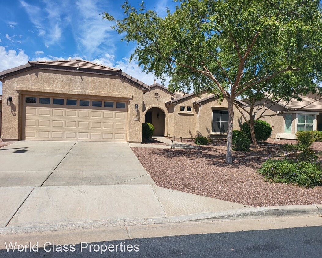
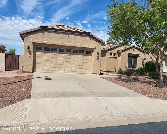
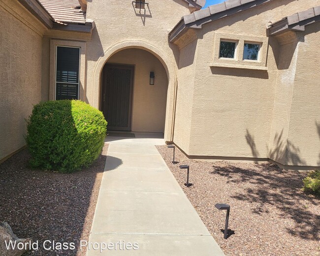
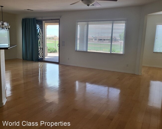
6832 S Santa Rita Way
Chandler, AZ 85249
Favorites
6832 S Santa Rita Way

Favorites
Check Back Soon for Upcoming Availability
| Beds | Baths | Average SF |
|---|---|---|
| 2 Bedrooms 2 Bedrooms 2 Br | 2 Baths 2 Baths 2 Ba | 1,788 SF |
About This Property
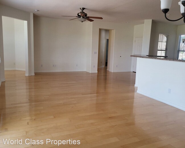
- 2 Bed/ 2 Bath in Adult Community - This stunning 2 Bedroom and 2 Bathroom with a Den on the golf course and in an Adult Community is the perfect place to call home. A kitchen with granite countertops, stainless steel and black appliances perfect for cooking the perfect meal. A large living space and generous bedrooms with hardwood floors. A spectacular outdoor entertaining area. This property is amazing and to top it off there is a garage and there is washer and dryer in unit. Plus a full amenity complex that includes a state-of-the-art fitness center, two outdoor resort-style pools, hobby studios, a grand ballroom, computer lab, and library. Outside has tennis, pickleball courts (YES PICKLEBALL COURTS), two bocce ball courts, and miles of walking and biking trails. The 18-hole championship Lone Tree Golf Club winds through the community with a stocked pro shop and even has an upscale restaurant, The Grille at Lone Tree. (RLNE8241006) Appliances: Range.
6832 S Santa Rita Way is a house located in Maricopa County and the 85249 ZIP Code. This area is served by the Chandler Unified District attendance zone.
6832 S Santa Rita Way,
Chandler,
AZ
85249
Nestled between Downtown Chandler and the Gila River Indian Reservation, South Chandler is a sizeable suburban area brimming with all kinds of modern conveniences. South Chandler residents enjoy easy access to a slew of shopping centers and plazas, many of which are clustered along South Alma School Road and South Arizona Avenue.
South Chandler offers plenty of recreational opportunities at Tumbleweed Park, Chuparosa Park, Snedigar Recreation Center, and Paseo Vista Recreation Area. The expansive San Tan Mountains Regional Park is also just minutes away from South Chandler. A wide variety of golf and country clubs are located in South Chandler as well.
Learn more about living in South ChandlerBelow are rent ranges for similar nearby apartments
| Beds | Average Size | Lowest | Typical | Premium |
|---|---|---|---|---|
| Studio Studio Studio | 546 Sq Ft | $1,469 | $1,684 | $3,533 |
| 1 Bed 1 Bed 1 Bed | 772 Sq Ft | $800 | $1,726 | $4,528 |
| 2 Beds 2 Beds 2 Beds | 1144-1145 Sq Ft | $1,503 | $2,291 | $7,307 |
| 3 Beds 3 Beds 3 Beds | 1516 Sq Ft | $1,906 | $2,712 | $7,621 |
| 4 Beds 4 Beds 4 Beds | 2762 Sq Ft | $2,289 | $3,599 | $10,000 |
Education
| Colleges & Universities | Distance | ||
|---|---|---|---|
| Colleges & Universities | Distance | ||
| Drive: | 10 min | 5.7 mi | |
| Drive: | 14 min | 7.2 mi | |
| Drive: | 23 min | 12.6 mi | |
| Drive: | 25 min | 13.2 mi |
6832 S Santa Rita Way is within 10 minutes or 5.7 miles from Chandler-Gilbert CC. Sun Lakes. It is also near Chandler-Gilbert C.C., Pecos and Arizona State Univ., Polytech.
Schools


Public Middle & High School
Grades PK & 6-12
2,825 Students
Attendance Zone
Public Elementary School
Grades PK-5
389 Students
Attendance Zone
Public Middle School
Grades 6-8
1,171 Students
Attendance Zone
Private Elementary & Middle School
Grades PK-8
195 Students
Nearby
Private Elementary School
Grades PK-5
Nearby
Private Middle & High School
Grades 6-12
43 Students
Nearby
School data provided by
 The GreatSchools Rating helps parents compare schools within a state based on a variety of school quality indicators and provides a helpful picture of how effectively each school serves all of its students. Ratings are on a scale of 1 (below average) to 10 (above average) and can include test scores, college readiness, academic progress, advanced courses, equity, discipline and attendance data. We also advise parents to visit schools, consider other information on school performance and programs, and consider family needs as part of the school selection process.
View GreatSchools Rating Methodology
Data provided by GreatSchools.org © 2026. All rights reserved.
View GreatSchools Rating Methodology
Data provided by GreatSchools.org © 2026. All rights reserved.
Walkability Near 6832 S Santa Rita Way Chandler, AZ 85249
Getting Around
 What do Walkability, Transit, Drivability, and Bikeability mean?
Walkability measures the walking distance to day-to-day needs.
Transit measures access to public transportation.
Drivability measures congestion, parking availability, and access to major roads.
Bikeability measures the suitability for cycling.
How It Works
What do Walkability, Transit, Drivability, and Bikeability mean?
Walkability measures the walking distance to day-to-day needs.
Transit measures access to public transportation.
Drivability measures congestion, parking availability, and access to major roads.
Bikeability measures the suitability for cycling.
How It Works
Somewhat Walkable
Walkability
20
/ 100
Exceptionally Drivable
Drivability
90
/ 100
Fairly Bikeable
Bikeability
40
/ 100
Scores provided by
-
Soundscore™
-
/ 100
Traffic
-Airport
-Businesses
-Scores provided by
HowLoud What is a Sound Score Rating? A Sound Score Rating aggregates noise caused by vehicle traffic, airplane traffic and local sources. How It WorksYou May Also Like
Similar Rentals Nearby
-
-
-
-
2 Beds$2,044Total Monthly Price12 Month LeaseTotal Monthly Price NewPrices include base rent and required monthly fees of $223. Variable costs based on usage may apply.Base Rent:2 Beds$1,780+2 Months Free
Pets Allowed In Unit Washer & Dryer CableReady Controlled Access Smoke Free Yard
-
-
2 Beds$2,430+3 Beds$2,740+Total Monthly Price12 Month LeaseTotal Monthly Price NewPrices include base rent and required monthly fees of $264. Variable costs based on usage may apply.Base Rent:2 Beds$2,150+3 Beds$2,475+Specials
Pets Allowed Fitness Center Dishwasher In Unit Washer & Dryer Stainless Steel Appliances Gated Yard
-
-
-
-


What Are Walk Score®, Transit Score®, and Bike Score® Ratings?
Walk Score® measures the walkability of any address. Transit Score® measures access to public transit. Bike Score® measures the bikeability of any address.
What is a Sound Score Rating?
A Sound Score Rating aggregates noise caused by vehicle traffic, airplane traffic and local sources.

6832 S Santa Rita Way
Chandler, AZ 85249